Lake Waitaki
| Lake Waitaki | |||||||||
|---|---|---|---|---|---|---|---|---|---|
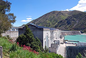
| Waitaki Dam as seen from the seaside | |||||||||
|
|||||||||
|
|
|||||||||
| Coordinates | 44 ° 40 '22 " S , 170 ° 23' 52" O | ||||||||
| Data on the structure | |||||||||
| Lock type: | Gravity dam | ||||||||
| Construction time: | 1928-1935 | ||||||||
| Height of the structure crown: | 230.8 m | ||||||||
| Crown length: | 522 m | ||||||||
| Power plant output: | 105 MW | ||||||||
| Operator: | Meridian Energy | ||||||||
| Data on the reservoir | |||||||||
| Water surface | 6.2 km² | ||||||||
| Reservoir length | 5.5 km | ||||||||
| Reservoir width | 2.16 km | ||||||||
| Total storage space : | 40 million m 3 | ||||||||
| Particularities: |
During floods, the excess water flows over the top of the dam |
||||||||
| Power plant with the dam in the background | |||||||||
The Lake Waitaki is a reservoir in the Waitaki District in the region Canterbury on the South Island of New Zealand .
geography
The reservoir is located around 63 km northwest of Oamaru and around 73 km southwest of Timaru . The New Zealand State Highway 83 passes on its south side , via which the lake can be reached from the east coast of the South Island. The small village of Kurow is on the route, around 5.5 km southeast of the dam. The slopes of the Kirkliston Range, which is up to 1,831 m high, run out on the northern shores of the lake . The up to 1942 m high St Marys Range rise slightly more gently from the south bank . The reservoir is fed by the outflow from Lake Aviemore, which is directly adjacent to the northwest . In the southeast of the lake is the Waitaki Dam with its outlet to the Waitaki River .
The content of the reservoir is 40 million m 3 of water. The minimum water level of the lake was set at 227 m above sea level , the dam crest is reached at 230.8 m . The average water level in the lake is 230.2 m .
Dam wall
The dam was the first major dam to be built on the South Island from 1928. It was designed and built by the Public Works Department at the time . The weight dam got a height of 33 m and extended with 522 m over the entire width of the valley. Other sources give the dam with a height of 48 m and a length of 542 m, whereby the former values indicate the length and height of the dam crest.
The construction of the dam does not include a separate water overflow. At high tide, the water simply runs over the top of the dam.
power plant
The dam's power plant was put into operation in October 1934 with initially two generators, each with a 15 MW line. In 1940, 1941 and 1949 another generator each followed with the same output. In 1954 two more generators were installed so that the power plant could have a maximum output of 105 MW and thus reached its final stage of expansion for a possible supply of around 51,000 households.
literature
- BK Rastogi, HK Gupta : Dams and Earthquakes . Elsevier Science , 1975, ISBN 978-0-444-60055-4 (English).
Web links
- Gavin McLean : Waitaki Damn . In: New Zealand History . Ministry for Culture & Heritage , 2013, accessed September 29, 2018 .
Individual evidence
- ↑ a b Topo maps . Land Information New Zealand , accessed September 29, 2018 .
- ↑ Rastogi, Gupta : Dams and Earthquakes . 1975, p. 104 .
- ↑ Lake Levels . Meridian Energy , accessed September 29, 2018 .
- ↑ a b Waitaki Power Station . Engineering New Zealand , accessed September 29, 2018 .
- ^ A b Gavin McLean : Waitaki Damn . In: New Zealand History . Ministry for Culture & Heritage , 2013, accessed September 29, 2018 .
- ^ Waitaki hydro station . Meridian Energy , accessed September 29, 2018 .


