
Laroque-des-Arcs
| Laroque-des-Arcs | ||
|---|---|---|
|
||
| local community | Bellefont-La Rauze | |
| region | Occitania | |
| Department | Lot | |
| Arrondissement | Cahors | |
| Coordinates | 44 ° 29 ′ N , 1 ° 28 ′ E | |
| Post Code | 46090 | |
| Former INSEE code | 46156 | |
| Incorporation | January 1, 2017 | |
| status | Commune déléguée | |

Laroque-des-Arcs ( Occitan : La Ròca dels Arcs ) is a village and a commune déléguée in the French commune Bellefont-La Rauze with 504 inhabitants (as of January 1, 2017) in the Lot department in the Occitania region .
The municipality of Laroque-des-Arcs merged with Cours and Valroufié on January 1, 2017 to form the Commune nouvelle Bellefont-La Rauze. It belonged to the Arrondissement of Cahors and the canton of Cahors-2 (until 2015: canton of Cahors-Nord-Est ).
geography
Laroque-des-Arcs is located on the southwestern edge of the Massif Central on several loops of the Lot River that form the southern municipal boundary. The river loops are enforced by the western edge of the Cevennes . The municipality of Laroque-des-Arcs was surrounded by the neighboring municipalities of Saint-Pierre-Lafeuille in the north and northwest, Valroufié in the north, Lamagdelaine in the east and southeast and Cahors in the south and west.
Population development
| 1962 | 1968 | 1975 | 1982 | 1990 | 1999 | 2006 | 2013 |
|---|---|---|---|---|---|---|---|
| 301 | 344 | 377 | 379 | 375 | 471 | 464 | 521 |
| Source: Cassini and INSEE | |||||||
Attractions
- Saint-Roch chapel from 1842
- Laroque Castle, Monument historique since 1963
- Ruins of the tower from the 12th century, monument historique since 1979
- Watermill

Saint Roch chapel

Laroque Castle
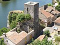
Remains of the occupation tower on the Lot

Watermill


