Lauske (Puschwitz)
|
Lauske
Łusč Community Puschwitz
Coordinates: 51 ° 14 ′ 16 ″ N , 14 ° 16 ′ 43 ″ E
|
|
|---|---|
| Height : | 185 m above sea level NN |
| Residents : | 89 (December 31, 2016) |
| Incorporation : | April 1, 1936 |
| Postal code : | 02699 |
| Area code : | 035933 |
|
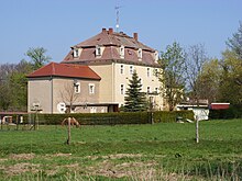
View from the northwest
|
|
Lauske , in Upper Sorbian , is a place in the center of the Bautzen district in East Saxony and has belonged to the Puschwitz community since 1936 . The place is part of the core settlement area of the Sorbs in Upper Lusatia . A large part of the population speaks Sorbian as their mother tongue.
geography
Lauske is located about 12 kilometers northwest of the large district town of Bautzen and 13 kilometers east of Kamenz in a spring valley from which a tributary of the Puschwitz water rises. The place is surrounded by hills on three sides. The foothills of the Guhraer Windmühlenberg (211 m) rise in the east, the Kirschberg (218 m) in the south and the Galgenberg (216 m) in the west . To the north the terrain slopes slightly towards Jeßnitz. The surrounding landscape is hardly forested and is used for agriculture. Lauske itself is a manor settlement with a residential area extending to the west.
The neighboring towns are Jeßnitz in the north, Guhra in the northeast, Neulauske in the southeast, Prautitz in the southwest and Crostwitz in the west. The Neujeßnitz settlement, which was laid out in 1828, is directly to the northeast.
history
The place was first mentioned in 1391 as Lusicz and in the 16th century also called Luschitz or Lauschitz . The place name comes - like " Lausitz " - from the word łuh for "grass swamp" or łuža for "puddle".
The manor was at the manor Holscha until 1792 , then Lauske became an independent estate. This founded the Neu-Lauske settlement about one kilometer south-east after 1800.
Until April 1, 1936 Lauske was an independent rural community with the district of Neu-Lauske. Then it was incorporated into Puschwitz.
population
In 1925 Lauske had 164 inhabitants; 118 of them were of the Catholic faith (72%). The place is parish after Crostwitz . The Protestant portion has been part of the Neschwitz parish since the 16th century .
For his statistics on the Sorbian population in Upper Lusatia, Arnošt Muka determined a population of 178 inhabitants in the 1880s; 165 of them were Sorbs (93%) and 13 were Germans.
After 1990 the population decreased slightly. The Sorbs make up a large part of the population .
Infrastructure
Lauske is characterized by a good road to the main road 100 (Bautzen-Kamenz) and the connection point Salzenforst of A 4 attached. A local road leads to Crostwitz. At the beginning of the 20th century, the plans for the Saxon Northeast Railway called for the construction of the Radibor-Kamenz line via Lauske. The place would have gotten a breakpoint. For various reasons, the plan was never implemented.
literature
- Western Upper Lusatia between Kamenz and Königswartha (= values of our homeland . Volume 51). 1st edition. Akademie Verlag, Berlin 1990, ISBN 3-05-000708-7 , p. 159.
Web links
- Lauske in the Digital Historical Directory of Saxony
- Neulauske in the Digital Historical Directory of Saxony
Individual evidence
- ↑ Ernst Tschernik: The development of the Sorbian population . Akademie-Verlag, Berlin 1954.


