
Guhra
|
Guhra
Hora Community Puschwitz
Coordinates: 51 ° 14 ′ 36 ″ N , 14 ° 17 ′ 9 ″ E
|
|
|---|---|
| Height : | 195 m above sea level NN |
| Residents : | 81 (December 31, 2016) |
| Incorporation : | April 1, 1936 |
| Postal code : | 02699 |
| Area code : | 035933 |
 Town view from the west; in the background the wind farm
|
|

Guhra , Upper Sorbian , is a village in the center of the East Saxon district of Bautzen and has been part of the Puschwitz community since 1936 . The place is part of the Sorbian core settlement area ; a large part of the population speaks Sorbian as their mother tongue.
geography
Guhra is located about 16 kilometers northwest of the large district town of Bautzen between the places Puschwitz in the north, Jeßnitz in the northwest and Lauske in the south at about 195 m above sea level. NN. It is about 10–20 meters higher than all neighboring towns. The surroundings rise gently to the east up to 211 meters, while the lowlands of two streams are to the north and west.
Guhra is a square village with a manor in the northern part.
population

In 1925, Guhra had 127 residents; 82 of them were Catholic (65%) and 44 were Evangelical Lutheran (35%). The place has belonged to the parish of Crostwitz (Catholic) and Neschwitz (Protestant) since the 16th century .
For his statistics on the Sorbian population in Upper Lusatia, Arnošt Muka determined a population of 111 inhabitants in the 1880s; 109 of them were Sorbs (98%) and two Germans.
Origin of name
The German name is derived from the Sorbian place name. Hora simply means "mountain" and indicates the elevated position of the place.
history
Guhra was first mentioned in 1312 as the manor of the Ticzko de Gor . The current form of the name has been proven since 1658. The Guhraer Rittergut is mentioned for the first time in 1606.
Until April 1, 1936, Guhra was an independent rural community with its district Neu-Jeßnitz ( Nowa Jaseńca ). Then it was incorporated into Puschwitz together with Jeßnitz and Lauske.
Economy and Infrastructure
The Wetro landfill is located about one kilometer northeast . Lignite was mined here until the 20th century . Nowadays there is a wind farm with ten wind turbines on the hill east of Guhra. As early as the 17th century there was a windmill at this point, which was dismantled in 1977 to protect against instability caused by opencast mining activities and moved to Quoos .
gallery
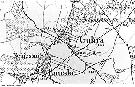
Guhra on the measuring table from 1884

The Guhraer wind farm
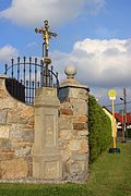
Wayside cross on the road to Jeßnitz
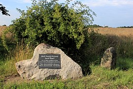
Memorial stone for Jakub Nowak
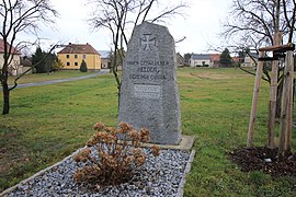
Monument to the fallen in the village


.jpg)
Web links
- Guhra in the Digital Historical Directory of Saxony
Individual evidence
- ↑ Ernst Tschernik: The development of the Sorbian population . Akademie-Verlag, Berlin 1954, p. 53 .