
Last (Schnega)
|
Afford
Schnega municipality
Coordinates: 52 ° 52 ′ 40 ″ N , 10 ° 54 ′ 10 ″ E
|
||
|---|---|---|
| Height : | approx. 55 m above sea level NN | |
| Incorporation : | July 1, 1972 | |
| Postal code : | 29465 | |
| Area code : | 05842 | |
Location of bars in the Lüchow-Dannenberg district |
||

Leisten is a district of the Schnega municipality in the Lüchow-Dannenberg district in Lower Saxony .
location
The district of the village borders on Schnega in the northeast and on the Schnega-Bahnhof district in the south. North of the village, along the Schnegaer mill trench , the 480 extends ha large nature reserve Schnegaer Mühlenbachtal . The district covers an area of 239 ha, of which 210 ha are used for agriculture (status 2004).
history
Early mentions of the place date from 1330/52 and 1450. The place was then called Lesten , the name probably derives from the Sorbian word lĕska for hazel bush . According to a register from 1564, there were seven farms and four small farms in the village; in 1777 there were twelve farms. The place has retained its predominantly agricultural character even today, but the number of farms fell to three full-time farms by 2004.
The first population figures have been handed down from 1821, when 118 people lived in the community. The number rose to 184 inhabitants by 1925 and reached its maximum with 288 inhabitants after the end of the Second World War in 1950. After that, the number fell steadily, in 2004 91 people lived here.
On July 1, 1972, Leisten was incorporated into the Schnega community and has been part of the Lüchow (Wendland) community since November 2006 .
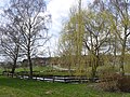
Village pond with a view of the village

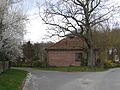
Courtyard on the former village square
former cold house on the former village square
_-_Dorfteich_mit_Blick_auf_den_Ort.jpg)
_-_Hofanlage.jpg)
_-_ehemaliges_Kalthaus.jpg)
literature
- Wendland Lexicon . Volume 2, L-Z. In: Wolfgang Jürries (Hrsg.): Series of publications of the local history working group Lüchow-Dannenberg . tape 13 . Köhring, Lüchow 2008, ISBN 978-3-926322-45-6 , pp. 43-44 .
Web links
- Photos from strips on wendland-archiv.de
- Last on beim-im-wendland.de
Individual evidence
- ^ Federal Statistical Office (ed.): Historical municipality directory for the Federal Republic of Germany. Name, border and key number changes in municipalities, counties and administrative districts from May 27, 1970 to December 31, 1982 . W. Kohlhammer GmbH, Stuttgart and Mainz 1983, ISBN 3-17-003263-1 , p. 230 .