Licoma
| Villa Libertad Licoma | ||
|---|---|---|
| Basic data | ||
| Residents (state) | 1773 pop. (2012 census) | |
| height | 1919 m | |
| Post Code | 02-1006-0100-8002 | |
| Telephone code | (+591) | |
| Coordinates | 16 ° 48 ′ S , 67 ° 12 ′ W | |
|
|
||
| politics | ||
| Department | La Paz | |
| province | Inquisivi Province | |
| climate | ||
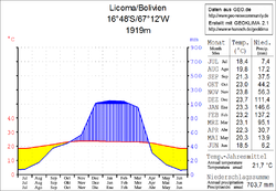
 Climate diagram Licoma |
||
Licoma (more precisely: Villa Libertad Licoma ) is a town in the La Paz department in the lowlands of the South American Andean state of Bolivia .
Location in the vicinity
Villa Libertad Licoma is the central place in the district ( Bolivian : Municipio ) Licoma Pampa in the Inquisivi province . The village is located at an altitude of 1919 m , twenty-five kilometers east of the snow-capped peaks of the Cordillera Real between the localities of Cajuata and Inquisivi .
geography
Villa Libertad Licoma is located in one of the valleys on the east side of the Quimsa Cruz cordillera , between the Bolivian Altiplano in the west and the Amazon lowlands in the east.
The mean average temperature of the region is around 22 ° C, the annual precipitation is 700 mm (see climate diagram). The region has a distinctive daytime climate, the monthly average temperatures fluctuate only slightly between 18 ° C in June / July and 24 ° C in November / December. The months April to October are arid , the monthly precipitation is between under 10 mm in the months of June and July and between 130 and 150 mm from January to February.
Transport network
Villa Libertad Licoma is located at a distance of 255 kilometers by road southeast of La Paz , the capital of the department of the same name.
From La Paz, the paved road Ruta 3 leads east to Unduavi , and from there Ruta 25 south-east for 195 kilometers via Chulumani and Irupana to Villa Libertad Licoma and via Inquisivi towards Cochabamba . In Inquisivi the route 109 branches off in a south-westerly direction , crosses the Serranía de Sicasica and ends at Belén on route 1 , which connects the cities of La Paz and Oruro .
population
The population of the village has more than doubled in the past two decades:
| year | Residents | source |
|---|---|---|
| 1992 | 795 | census |
| 2001 | 1 036 | census |
| 2012 | 1 773 | census |
Individual evidence
- ^ INE - Instituto Nacional de Estadística Bolivia 1992
- ^ INE - Instituto Nacional de Estadística Bolivia 2001
- ↑ INE - Instituto Nacional de Estadística Bolivia 2012 ( Memento of the original from July 22, 2011 in the Internet Archive ) Info: The archive link has been inserted automatically and has not yet been checked. Please check the original and archive link according to the instructions and then remove this notice.
Web links
- Relief map of the Inquisivi region 1: 250,000 (PDF; 7.67 MB)
- Municipio Licoma Pampa - General Maps No. 21006
- Municipio Licoma Pampa - detailed map and population data (PDF; 370 kB) ( Spanish )
- Departamento La Paz - social data of the municipalities (PDF; 11.63 MB) ( Spanish )
