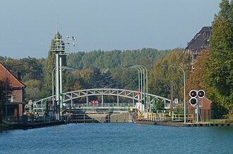
Linden harbor lock

The Lindener Hafen-Schleuse in Hanover , also called Hafenschleuse Linden , is a lock built at the beginning of the 20th century between the Lindener Hafen and the Hanover-Linden branch canal leading to the Mittelland Canal or the Leine descending canal . The listed building can be found in what is now Hanover's Limmer district in the triangle between Sichelstraße at Limmerbrunnen and the extension of Harenberger Straße , which was named Zum Schleusengrund in 2003 along the old road to Harenberg .
History and description

At the time of the German Empire and in the middle of World War I , the Lindener Hafen-Schleuse was built between 1916 and 1917 in order to overcome the level difference between the branch canal and the 7.80 meter higher basin of the Lindener Hafen. The Braunschweig Waterways and Shipping Office specifies a construction period from 1914 to 1917 and a level difference of 7.70 meters.
The 85 m long and 10 m wide chamber lock was designed for the ship's dimensions customary at the time, which was 67 m long and 8.20 m wide for a loading depth of 1.75 m. The Lindener Hafen-Schleuse is too small for modern large motor cargo ships and push convoys, so that the Lindener Hafen cannot be approached by these types of ships. European ships (85 m in length) can only be funneled with a special permit.
Therefore, an expansion of both the branch canal and the lock was planned, but this is now considered unlikely.
See also
Web links
- oV : Station 17 - Linden harbor lock: space for 83-meter barges on the hannover.de site
- N / A: Linden lock on the side of the Braunschweig Waterways and Shipping Office
Individual evidence
- ↑ a b c d e Waldemar R. Röhrbein : Linden harbor lock. In: Klaus Mlynek, Waldemar R. Röhrbein (eds.) U. a .: City Lexicon Hanover . From the beginning to the present. Schlütersche, Hannover 2009, ISBN 978-3-89993-662-9 , p. 409.
- ↑ above: Station 17 - Linden harbor lock: space for 83-meter barges on the hannover.de website , last accessed on January 4, 2017
- ↑ Dierk Schröder, Thilo Wachholz (ed.), Dirk Altwig (collaborator): The construction of the Mittelland Canal as far as Hanover , in this: Urban landscape and bridges in Hanover. The Mittelland Canal as a modern shipping route , ed. from the Wasser- und Schifffahrtsdirektion Mitte, Hannover, Hannover: Schlütersche, 2000, ISBN 978-3-87706-557-0 , p. 22; Preview over google books
- ↑ Compare the location map 7 / ... 30 Limme. In: Monument topography of the Federal Republic of Germany , architectural monuments in Lower Saxony, City of Hanover (DTBD), part 2, vol. 10.2, ed. by Hans-Herbert Möller , Lower Saxony State Administration Office - Institute for Monument Preservation , Friedr. Vieweg & Sohn Verlagsgesellschaft mbH, Braunschweig 1985, ISBN 3-528-06208-8 , p. 48; and Limmer in the addendum : List of architectural monuments according to § 4 ( NDSchG ) (except for architectural monuments of the archaeological monument preservation), status: July 1, 1985, City of Hanover , Lower Saxony State Administration Office - publications of the Institute for Monument Preservation , p. 24f.
- ↑ Helmut Zimmermann : Zum Schleusengrund , in Karljosef Kreter (Red.): Hannoversche Geschichtsblätter , New Series, Vol. 51, 1997, p. 360
- ↑ Lock Linden on the side of the Waterways and Shipping Office Braunschweig
- ↑ Branch sewer will not be expanded in HAZ from November 19, 2011
Coordinates: 52 ° 22 ′ 43.1 " N , 9 ° 40 ′ 51.5" E
