
List of architectural monuments in Bad Neustadt an der Saale
The monuments of the Lower Franconian town of Bad Neustadt an der Saale are compiled on this page . This table is a partial list of the list of architectural monuments in Bavaria . The basis is the Bavarian Monument List , which was first drawn up on the basis of the Bavarian Monument Protection Act of October 1, 1973 and has since been managed by the Bavarian State Office for Monument Preservation . The following information does not replace the legally binding information from the monument protection authority. This list reflects the update status as of February 8, 2020 and contains 200 architectural monuments.

Ensembles
Ensemble old town Bad Neustadt an der Saale
Between the original parish of Brendlorenzen an der Brend and the old royal court of Salz an der Saale, the independently developed settlement lies on a bump above the confluence of the Brend and the Franconian Saale. On 9/11 Called Obersalz in the 19th century, the city was first handed down as Neustadt in 1232. The core of the settlement lies in the area around the parish church, market square and cellar lane, which is joined as the Neustadt by the parts around Hohnstrasse and Spörleinstrasse. The resulting heart-shaped city plan shows the adaptation of a grid system to the shape of the terrain, which is the rule for Gothic city structures. The main street (Hohnstrasse and Spörleinstrasse), which ran from the southwest to the northeast, formerly from gate to gate, sends in its middle course a spacious, elongated market square at right angles to the northwest. The side streets run parallel to the main street throughout. The plots of land develop as narrow towels deep into the building blocks and usually carry former agricultural property with the residential building facing the street and farm buildings staggered backwards. In most cases there is no access to the rear building through the rear parallel lane, the entrance to the courtyard is through a gate in the street front. The street scenes result from the closed row of gabled houses. An exception is the Bauerngasse, which follows the western outskirts of the city, the former farms of which each have a wider street front; the houses there are mostly on the eaves. Two to three-storey half-hipped roof houses from the 18th and 19th centuries are decisive for the cityscape. Century in half-timbered construction with plastered outer walls. Some older gabled houses, some with exposed half-timbering, are on the market and in the main street. There, the old building fabric is mixed with new buildings, the ground floors appear hollowed out for shop fittings throughout. The lower course of the Hohnstrasse is given a special character by the gate tower of the Hanntore in Renaissance forms and by two inns with rich baroque facades. The early baroque building of the former Würzburg official building dominates the Spörleinstraße. The parish is located in the north of the city, but the classicist tower of the parish church has a decisive effect on the square of the market. Further monumental islands within the arable city structure form the former Carmelite monastery, the former cloister courtyard of the Bildhausen monastery and the former Würzburg official cellar. As a special feature, the city fortifications with the Zwingermauer, three round towers and moat area have been preserved almost throughout. Boundary: city wall. File number E-6-73-114-1.
Ensemble town center Brendlorenzen
The ensemble includes part of the extraordinarily elongated street village , which was created in the early Middle Ages when the towns of Brend and Lorenzen grew together. The street is accompanied by farms, the houses of which, in a slightly offset gable position, are connected by courtyard gate walls. The saddle roof houses, many from the 18th century and with additions from the 19th century, often have plastered half-timbered upper floors. The historical townscape with the preserved barn edges and gardens is disturbed by some new buildings. Boundary: Hauptstrasse 106, 108, 110, 112, 114-139, 141, 143, 145, 147, 149, 151, 153. File number: E-6-73-114-2.
City fortifications Neustadt

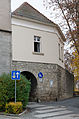
The city fortifications were laid out in the 13th century, and were substantially renewed and expanded in the 16th century. It has been preserved in its entire course, but not in its original height. Of the two main gates, the gate tower of the Hehntor (cf. Hohnstrasse 39) has been preserved, two pillars were erected in place of the Spörlein gate after the demolition in 1846 (cf. Spörleinstrasse, two gate pillars), two gates (church and salt gate) are in the north-south Crosswise, the kennel still exists for long stretches, the former kennel wall in the area northwest of the Hanntor is now used as a cemetery wall (see cemetery, Schweinfurter Straße 2). Three high round towers strengthen the western section of the wall: round tower with crenellated ends at the house gate at the cemetery, middle round tower with conical roof, north-western round tower with bay windows and crenellated ends. The south-east corner was reinforced in the 16th century by an upper bastion tower and a round tower with a conical roof in front of the kennel wall. The course of the wall is along the Alte Pfarrgasse lots with odd numbers 1–19; Apothekengasse 21, 23, 25, Bauerngasse odd numbers 1–43, Hohnstrasse 33, 35, 37, 39, Roßmarktstrasse even numbers 4–50, Salzpforte 3, 6 1/2, 8, Schuhmarktstrasse 20, 25, Spörleinstrasse 2, 10, Steingasse odd numbers 5–17. In the Gerberspfad-Goethestrasse area, the expiring kennel wall with reliefs and inscriptions has been redesigned as a memorial for the victims of war and violence. File number: D-6-73-114-2. The following parts of the city fortifications have been preserved, starting from the Hanntor.
| location | object | description | File no. | image |
|---|---|---|---|---|
| Hohnstrasse 39 ( location ) |
House gate | Six-storey gate tower with barrel-vaulted passage and volute gables, three-storey Wendelstein on the side, polygonal cast bay windows and baroque niche figure, Saint Kilian, the interior from 1977–1979, two coats of arms, Julius Echter von Mespelbrunn and city coat of arms, with significant involvement of Niklas Bayer 1578 built | D-6-73-114-41 |
 more pictures |
- Hohnstraße 39 ( location ): city wall, 13. – 16. Century, D-6-73-114-41
- Bauerngasse 1 ( location ): city wall, 13. – 16. Century, D-6-73-114-14
- Bauerngasse 13 ( location ): round tower with battlements, D-6-73-114-2
- Bauerngasse 21 ( location ): city wall, 13. – 16. Century, D-6-73-114-22
- Bauerngasse 25 ( location ): Round tower with conical roof, D-6-73-114-2
- Bauerngasse 29 ( location ): city wall, 13th-16th centuries Century, D-6-73-114-24
- Bauerngasse 33 ( location ): north-western round tower with bay windows and battlements, D-6-73-114-2
- Bauerngasse 39 ( location ): city wall, 13. – 16. Century, D-6-73-114-27
- Schuhmarktstraße 25 ( location ): City wall with kennel wall and half-shell tower, 13. – 16. Century, D-6-73-114-2
- Schuhmarktstraße 20 ( location ): City wall with kennel wall and half-shell tower, 13. – 16. Century, D-6-73-114-2
- Church gate ( location ): Triple city wall with passage, D-6-73-114-2
- Alte Pfarrgasse 3 ( location ): city wall, 13./16. Century, D-6-73-114-3
- Alte Pfarrgasse 5 ( location ): city wall, 13./16. Century, D-6-73-114-2
- Alte Pfarrgasse 7 ( location ): city wall, 13./16. Century, D-6-73-114-258
- Alte Pfarrgasse 15 ( location ): City wall, 13./16. Century, D-6-73-114-2
- Alte Pfarrgasse 17 ( location ): city wall, 13./16. Century, D-6-73-114-2
- Spörleinstraße 10 ( location ): City wall, 13./16. Century, D-6-73-114-101
- On the Zollberg, from the church gate to the Spörleinstor ( location ): city wall, 13./16. Century, D-6-73-114-101
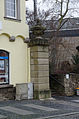
- At the Zollberg ( location ): two gate pillars with vase attachments, in place of the Spörleinstore, 1846, D-6-73-114-97
- Outer city wall ( location ): stump of a half-shell tower, D-6-73-114-2
- Outer city wall ( location ): stump of a rectangular tower, D-6-73-114-2
- Inner city wall ( location ): Upper Bastion Tower, 16th century, D-6-73-114-2
- Outer city wall ( location ): round tower, with a conical roof, reinforcing the upper bastion tower, D-6-73-114-84
- Roßmarktstraße 24 ( location ): city wall, 13. – 16. Century, D-6-73-114-82
- Roßmarktstraße 16 ( location ): City wall, 13. – 16. Century, D-6-73-114-80
- Roßmarktstraße 10, 12 ( location ): city wall, 13. – 16. Century, D-6-73-114-78
- Salzpforte ( location ): Salzpforte, D-6-73-114-2
- Hohnstraße 31 ( location ): city wall, 13. – 16. Century, D-6-73-114-39
- Hohnstraße 35 ( location ): city wall, 13. – 16. Century, D-6-73-114-39
- Hohnstraße 37 ( location ): city wall, 13. – 16. Century, D-6-73-114-40

City wall Hohnstrasse 39

City wall Bauerngasse 1

Round tower Bauerngasse 13
more pictures
City wall at Bauerngasse 21, 23, 25

Round tower Bauerngasse 25
more pictures
Round tower Bauerngasse 33
more pictures
Half-shell tower of the Zwingermauer Schumarktstrasse 25
additional pictures
Half-shell tower of the Zwingermauer Schumarktstrasse 20
more pictures
Upper kennel wall west of the church gate
more pictures
Bottom wall at the church gate Goethestrasse
more pictures
Half-shell tower at the church gate
more pictures
Church gate city side
more pictures
Zwinger Am Zollberg
Northern gate pillar Am Zollberg
more pictures
Südlicher Torpfeiler Am Zollberg
more pictures
Turmstumpf, Roßmarktstraße 31
more pictures
Tower stump, Roßmarktstrasse 50

Upper bastion tower
more pictures
Round tower with conical roof
more pictures
West salt gate

West salt gate
Hohnstrasse 37


Architectural monuments according to districts
Bad Neustadt an der Saale
In the old town of Bad Neustadt an der Saale, pictures of squares and streets are of particular importance. First, the monuments in these areas are listed; then the rest of the core city.
Bauerngasse
Boundary: Bauerngasse 1-41, 43, Kellereigasse 11, 18, Storchengasse 19.
| location | object | description | File no. | image |
|---|---|---|---|---|
| Bauerngasse 1 ( location ) |
Half hipped roof house | Two-story corner house, half-timbered upper floor plastered, 18./19. century | D-6-73-114-14 |
 more pictures |
| Bauerngasse 8 ( location ) |
Dreiseithof | Two-storey with massive ground floor, half-timbered upper floor and half-hipped roof, 18th / 19th century. Century, over the older core, entrance gate marked "1627" | D-6-73-114-17 |
 more pictures |
| Bauerngasse 8 ( location ) |
Dreiseithof | Courtyard wall | D-6-73-114-17 |
 more pictures |
| Bauerngasse 19 ( location ) |
Agricultural bourgeoisie | Massive ground floor with side gate passage, slightly protruding plastered half-timbered upper floor, hipped roof, profiled archway with seating niches, 17th century | D-6-73-114-21 |
 more pictures |
| Bauerngasse 21 ( location ) |
Residential building | Stately gable-independent half hipped roof building with massive ground floor and plastered half-timbered upper floor, 17th / 18th century | D-6-73-114-22 |
 more pictures |
| Bauerngasse 29 ( location ) |
Residential building | Two-storey eaves saddle roof building with solid ground floor, here profiled frame shapes, upper floor plastered half-timbering, 18th century | D-6-73-114-24 |
 more pictures |
| Bauerngasse 38 ( location ) |
Residential building | Eaves, two-story, massive ground floor, half-timbered upper floor, gable roof, 18th century | D-6-73-114-26 |
 more pictures |
| Bauerngasse 39 ( location ) |
Agricultural bourgeoisie | Two-storey plastered façade building, massive ground floor with central gate passage, half-timbered upper floor, gable roof, 17th century | D-6-73-114-27 |
 more pictures |
| Bauerngasse 40, 40a ( location ) |
Gate | Arched stone, inscribed "1581" | D-6-73-114-28 |
 more pictures |
Hohnstrasse
Boundary: Hohnstrasse 1, 2, 2 1/2, 3-35, 37, 39.
| location | object | description | File no. | image |
|---|---|---|---|---|
| Hohnstrasse 1 ( location ) |
Half hipped roof construction | Corner building on an angled floor plan, three-storey, upper storeys in plastered half-timbering, 17th / 18th centuries century | D-6-73-114-33 |
 more pictures |
| Hohnstrasse 1, at the rear building, Roßmarktstrasse ( location ) |
Inscription panels | Marked "1581" and "1847" | D-6-73-114-33 |
 more pictures |
| Hohnstrasse 3 ( location ) |
Former wedge stone with relief head | Classicist, early 19th century | D-6-73-114-34 |
 more pictures |
| Hohnstrasse 6 ( location ) |
Courtyard gate | Round arch with inscription in the keystone, inscribed "1650" | D-6-73-114-35 |
 more pictures |
| Hohnstrasse 19 ( location ) |
Residential and commercial building | Two-storey corner building with half-hipped roof, massive ground floor with profiled drilled door and window walls, upper floor plastered half-timbering, 18th century | D-6-73-114-36 |
 more pictures |
| Hohnstrasse 19 ( location ) |
House Madonna | Mounted late baroque stone figure, 18th century | D-6-73-114-36 |
 more pictures |
| Hohnstrasse 26 ( location ) |
Former guest house at the golden lion | Eaves side house with richly structured facade, in the left part rusticated basket arch gate with pilasters, lion sculptures and inscription plaque, inscribed "1785" | D-6-73-114-37 |
 more pictures |
| Hohnstrasse 26 ( location ) |
Former guest house at the golden lion | Wrought iron pub sign | D-6-73-114-37 |
 more pictures |
| Hohnstrasse 26 ( location ) |
Former guest house at the golden lion | Two wrought iron gargoyles | D-6-73-114-37 |
 more pictures |
| Hohnstrasse 35 ( location ) |
Gasthof Schwan and Post | Two-storey, late baroque, plastered solid building with a mansard hipped roof, rich facade structure through corner pilasters, drilled window walls and profiled house door walls with skylight and arched field, 1772/73 (dendrochronologically dated) | D-6-73-114-39 |
 more pictures |
| Hohnstrasse 35 ( location ) |
Gasthof Schwan and Post | Two niche figures, St. Michael and St. Ursula | D-6-73-114-39 |
 more pictures |
| Hohnstrasse 35 ( location ) |
Gasthof Schwan and Post | Curtain arch gate, inscribed "1812" | D-6-73-114-39 |
 more pictures |
Cellar alley
Boundary: Kellereigasse 4a, 6-12, 14, 16, 18, Bauerngasse 21.
| location | object | description | File no. | image |
|---|---|---|---|---|
| Kellereigasse 6 ( location ) |
Agricultural bourgeoisie | At the gable end, two-storey, plastered half-timbering, gable roof, 18th century | D-6-73-114-42 |
 more pictures |
| Kellereigasse 7 ( location ) |
Former Würzburg official winery | Prison since 1817, three-wing complex of two- to three-story buildings with saddle roofs, one wing with stepped gable, around 1610 (dendrochronologically dated), three-story east wing with coupled, high-rectangular Renaissance windows, 1352 (dendrochronologically dated), roof around 1500 (dendrochronologically dated, two-story north-east wing 1570 i), south wing around 1765 (dendrochronologically dated) | D-6-73-114-43 |
 more pictures |
| Kellereigasse 7 ( location ) |
Former Würzburg official winery | Courtyard wall with bricked up older round arched gate, 17th / 18th centuries Century, and younger central courtyard gate, 19th century | D-6-73-114-43 |
 more pictures |
| Kellereigasse 8 ( location ) |
Agricultural bourgeoisie | Two-storey eaves side building, massive ground floor with late baroque window frames and arched side gate passage, upper floor plastered half-timbering, inscribed "1754" | D-6-73-114-44 |
 more pictures |
| Kellereigasse 18 ( location ) |
Residential building | Small corner house with half-hipped roof, plastered half-timbering with protruding floor sleepers, 17th / 18th centuries. Century, with the roof towed to the courtyard | D-6-73-114-45 |
 more pictures |
| Kellereigasse 18 ( location ) |
enclosure | Arched gate | D-6-73-114-45 |
 more pictures |
Marketplace
Boundary: Marktplatz 1-27, 29, 31, 33, 35, 37, Hohnstraße 1.
| location | object | description | File no. | image |
|---|---|---|---|---|
| Marketplace ( location ) |
Market fountain | Base with four basins, above a fluted column, 1881, crowned by a statue of a spring nymph, 17th century | D-6-73-114-67 |
 more pictures |
| Marketplace 1 ( location ) |
Residential and commercial building | Attached to the gable, two-storey, half-timbered, gable roof, early 16th century | D-6-73-114-50 |
 more pictures |
| Marketplace 3 ( location ) |
Residential and commercial building | Three-storey corner house with gable facing the market, plastered half-timbering, half-hipped roof, 17th / 18th centuries century | D-6-73-114-51 |
 more pictures |
| Marketplace 7 ( location ) |
Community center | Solid construction with hipped roof, drilled frame shapes, around 1750, bay window with grape bear relief, historicistic | D-6-73-114-52 |
 more pictures |
| Marktplatz 7, on Roßmarktstrasse ( location ) |
Quarry stone barn | With gable roof, 17th / 18th centuries century | D-6-73-114-52 |
 more pictures |
| Marktplatz 9 ( location ) |
Residential and commercial building | Three-storey solid building, gable-free, with crooked hip, frame shapes, 18th century | D-6-73-114-53 |
 more pictures |
| Marktplatz 12 ( location ) |
City pharmacy | Two-storey gable-independent half-hipped roof house, plastered half-timbering, frame shapes, 1750 | D-6-73-114-54 |
 more pictures |
| Marktplatz 14 ( location ) |
Residential and commercial building | Two-storey, gable-free, half-hipped roof, plastered half-timbering, 18th century | D-6-73-114-55 |
 more pictures |
| Marktplatz 16 ( location ) |
Residential and commercial building | Three-storey, gable-independent half-hipped roof building, plastered half-timbering, with protruding upper storeys, 17th century | D-6-73-114-56 |
 more pictures |
| Marktplatz 17 ( location ) |
Community center | Gable-independent, two-storey, gable roof, half-timbered upper floor of the 16th century partially changed, half-timbered gable 16th century | D-6-73-114-57 |
 more pictures |
| Marktplatz 18 ( location ) |
Madonna relief | 18th century | D-6-73-114-58 |
 more pictures |
| Marktplatz 19 ( location ) |
Community center | At the gable end with a half-hipped roof, massive ground floor, plastered half-timbered upper floor, 17th century, archway marked "1494" | D-6-73-114-59 |
 more pictures |
| Marktplatz 21, in Storchengasse ( location ) |
House brand of a baker | 18th century, and Keilstein, 1866 | D-6-73-114-60 | |
| Marktplatz 21, in Storchengasse ( location ) |
Outbuildings | Half-timbered building with half-hipped roof and gate with wheel deflectors | D-6-73-114-60 |
 more pictures |
| Marktplatz 23 ( location ) |
Residential and commercial building | Corner house, three-storey with half-hipped roof, with a two-storey extension, plastered half-timbering, frame shapes, 18th century | D-6-73-114-62 |
 more pictures |
| Marktplatz 23 ( location ) |
Courtyard gate | Designated "1680" | D-6-73-114-62 |
 more pictures |
| Marketplace 23; at the rear building ( location ) |
Tympanum | With the Eye of God and two decorative keystones with rocaille shapes, inscribed "1773" | D-6-73-114-62 |
 more pictures |
| Marktplatz 25 ( location ) |
Community center | Eaves side house, three-storey, half-timbered structure, steep pitched roof, frame shapes, bay window marked "1686" | D-6-73-114-64 |
 more pictures |
| Marktplatz 29 ( location ) |
Residential and commercial building | Three-storey, gable-free, plastered framework, saddle roof, 16./17. century | D-6-73-114-65 |
 more pictures |
Rossmarktstrasse
Boundary: Roßmarktstraße 2, 4, 6, 7, 8, 10, 12, 14, 14 1/2, 16, 17, 17 1/2, 18, 20, 30-32, 34, 36, 38, 40, 42 , 44, 46, 48, 50, Marktplatz 7, Salzpforte 1, Zwiebelgasse 9.
| location | object | description | File no. | image |
|---|---|---|---|---|
| Roßmarktstrasse ( location ) |
Former portal crown | 18th century | D-6-73-114-84 |
 more pictures |
| Roßmarktstraße 10, 12 ( location ) |
Agricultural bourgeoisie | Eaves, two-storey, ground floor massive with side gate passage, gate marked “1612”, upper floor plastered half-timbering, frame shape 18th century | D-6-73-114-78 |
 more pictures |
| Roßmarktstraße 16 ( location ) |
Community center | Two-story, half-hipped gable, plastered half-timbering, frame shapes, 18th century | D-6-73-114-80 |
 more pictures |
| Roßmarktstraße 24 ( location ) |
Agricultural bourgeoisie | Two-storey gable-independent, plastered half-timbering, gable roof, 17th century, ground floor gutted | D-6-73-114-82 |
 more pictures |
Spörleinstrasse
Boundary: Spörleingasse 1-18, 20, 22, 24, 26, 28, 30, 32, 34, 36, 38, Rathausstraße 2.
| location | object | description | File no. | image |
|---|---|---|---|---|
| Spörleinstraße 3 ( location ) |
Gasthof Fränkischer Hof | Gable-independent two-storey half-hipped roof building, massive ground floor with side gate passage, half-timbered upper floor, in the core end of the 15th century, courtyard gate marked "1493" | D-6-73-114-99 |
 more pictures |
| Spörleinstraße 3 ( location ) |
Gasthof Fränkischer Hof | At the rear three-sided outbuildings framing the courtyard, half-timbered with a gable roof, arcade, 17th / 18th century. century | D-6-73-114-99 |
 more pictures |
| Spörleinstraße 10 ( location ) |
So-called former Jewish house | Three-storey eaves side building with stone-faced neo-Romanesque facade, gable roof, around 1870 | D-6-73-114-101 |
 more pictures |
| Spörleinstraße 11 ( location ) |
Former Würzburg office building | Now district office, three-storey hipped roof building, plastered with structural elements in natural stone, elaborate main portal with rich coat of arms decorations (Prince-Bishops Johann Philipp von Greiffenklau-Vollraths and Johann Philipp Franz von Schönborn) above the lintel, 1716–1720 by court architect Joseph Greising | D-6-73-114-102 |
 more pictures |
| Spörleinstraße 13 ( location ) |
Duplex | Two-storey, gable-independent, gable roof building with stepped gable, 1863 and 1898 and half-timbered house with half-hipped, 18th century; both buildings over an older core | D-6-73-114-1 |
 more pictures |
| Spörleinstraße 18 ( location ) |
Residential and commercial building | Three-storey at the gable, plastered framework with stepping thresholds, half-hipped roof, 17th century | D-6-73-114-103 |
 more pictures |
| Spörleinstraße 28 ( location ) |
Residential and commercial building | Three-storey with hipped roof, plastered half-timbering, 18th century | D-6-73-114-104 |
 more pictures |
| Spörleinstraße 32 ( location ) |
Narrow residential and commercial building | Three-storey, at the gable end, with a crippled hip, plastered framework, 17th / 18th century. century | D-6-73-114-105 |
 more pictures |
| Spörleinstraße 34 ( location ) |
Residential and commercial building | Three-storey, at the gable end with a half-hipped roof, plastered framework, baroque Trinity relief, 18th century | D-6-73-114-106 |
 more pictures |
| Spörleinstraße 36 ( location ) |
Residential and commercial building | Attached to the gable, massive ground floor with round arched side entrance, plastered framework, gable roof, 17th / 18th century. century | D-6-73-114-107 |
 more pictures |
| Spörleinstraße 38 ( location ) |
Residential and commercial building | Three-storey corner house with hipped roof, plastered half-timbering, 17th century | D-6-73-114-108 |
 more pictures |
Storchengasse
Boundary: Storchengasse 1-19, Spitalgasse 3, Bauerngasse 8.
| location | object | description | File no. | image |
|---|---|---|---|---|
| Storchengasse 4 ( location ) |
Former house in a courtyard | Two-storey, independent of the gable, massive ground floor with baroque window frames, half-timbered upper storey, gable roof, 18th century | D-6-73-114-111 |
 more pictures |
| Storchengasse 5 ( location ) |
Community center | Three-storey eaves side building with saddle roof and protruding plastered half-timbered upper storeys, 17th / 18th centuries century | D-6-73-114-112 |
 more pictures |
| Storchengasse 8 ( location ) |
Residential and commercial building | Two-storey with a gable roof, plastered framework, inscribed "1673" | D-6-73-114-113 |
 more pictures |
| Storchengasse 9 ( location ) |
Community center | Attached to the gable, two-storey, plastered framework, saddle roof, side gate passage, 17th / 18th century. century | D-6-73-114-114 |
 more pictures |
| Storchengasse 15 ( location ) |
Community center | Two-storey, massive ground floor, plastered half-timbered upper floor, hipped roof, frame shapes, goal posts, around 1450 (originally red and white corner pilasters), baroque overmolding (with window axes, stone walls for windows and doors, all-round eaves beam, plastered corner cuboids, trowel plaster) in the 18th century. | D-6-73-114-117 |
 more pictures |
Remaining streets in the Old Town ensemble
| location | object | description | File no. | image |
|---|---|---|---|---|
| Alte Pfarrgasse 3 ( location ) |
Former picture houses courtyard | 1803–1931 Rentamt, irregular three-wing complex, two-storey renaissance building with eaves, plastered construction, solid ground floor, half-timbered upper storey and volute gable, first half of the 17th century | D-6-73-114-3 |
 more pictures |
| Alte Pfarrgasse 3 ( location ) |
Former picture houses courtyard, front building | Two-storey plastered building with hipped roof on an angled floor plan |
 more pictures |
|
| Alte Pfarrgasse 3 ( location ) |
Former picture houses courtyard | Statue of Our Lady, sandstone, 18th century (formerly Marktplatz 22) | D-6-73-114-3 |
 more pictures |
| Alte Pfarrgasse 3 ( location ) |
Former picture houses courtyard | Corner building on the courtyard side with a mansard roof | D-6-73-114-3 |
 more pictures |
| Alte Pfarrgasse 3 ( location ) |
Former picture houses courtyard | On the wing in front of the city wall two coat of arms stones from the 18th century (one marked "1761") and a dating stone, marked "1494" | D-6-73-114-3 |
 more pictures |
| Alte Pfarrgasse 5 ( location ) |
Small house | Eaves, two-storey, with half-timbered upper storey and gable roof, 17th / 18th century. century | D-6-73-114-4 |
 more pictures |
| Alte Pfarrgasse 7 ( location ) |
Small house | Eaves, two-storey, with half-timbered upper storey and steep pitched roof, 17th / 18th centuries Century, lintel marked "1816" | D-6-73-114-258 |
 more pictures |
| Am Zollberg ( location ) |
Crucifixion group | In front of a semicircular brick niche, late Baroque figures on plinths, tabernacle with angels at the base of the cross, on the side, placed on the niche wall, rococo vases with angels, 1765 | D-6-73-114-9 |
 more pictures |
| Apothekengasse 14 ( location ) |
Eaves side house | Three-story, massive ground floor, upper floors plastered half-timbering, gable roof, 17th century | D-6-73-114-12 |
 more pictures |
| Gerberspfad ( location ) |
War memorial for 1870/71 | Obelisk with reliefs and inscriptions, crowned by a warrior helmet, inscribed "1907" | D-6-73-114-6 |
 more pictures |
| Goethestraße 17, near Schweinfurter Straße ( location ) |
Cemetery with cemetery wall | 19th century, using the old castle wall on the town side (see town fortifications) | D-6-73-114-91 |
 more pictures |
| Goethestraße 17, near Schweinfurter Straße ( location ) |
Cemetery chapel | 19th century, altar around 1750, integrated into the covered area behind the entrance wall | D-6-73-114-91 |
 more pictures |
| Goethestraße 17, near Schweinfurter Straße ( location ) |
Fourteen Stations of the Cross | Sandstone reliefs, mid-19th century, on the cemetery wall | D-6-73-114-91 | |
| Goethestraße 17, near Schweinfurter Straße ( location ) |
Cemetery cross | Mid 19th century | D-6-73-114-91 |
 more pictures |
| Goethestraße 17, near Schweinfurter Straße ( location ) |
graveyard | Gravestones from the 17th, 18th and first half of the 19th century, walled in in the entrance wall or erected in front of it, furthermore the Endres-Brust family grave with expressionist figural decoration, 1922 | D-6-73-114-91 |
 more pictures |
| Near Goethestrasse ( location ) |
Cross tug | Sandstone, 18th century | D-6-73-114-32 |
 more pictures |
| Klosterkirchengasse 1 ( location ) |
Former Carmelite Monastery Church of St. Peter and Paul | Abolished in 1803, owned by the city since 1838, hall building with a north aisle and rectangular choir, changed around 1352, windows and pillars 1611 and 1679 (d), tower with pointed helmet at the southeast corner from 1611, furnishings of the chapel with a pent roof at the end of the Aisle next to the choir as Loretto Chapel in 1684, extension of the Anna Chapel on the nave in 1693; with equipment | D-6-73-114-49 |
 more pictures |
| Klosterkirchengasse 1, outside of the Lorettakapelle ( location ) |
Stone figure | Our Lady of Mount Carmel | D-6-73-114-49 |
 more pictures |
| Rathausgasse 2 ( location ) |
town hall | Three-storey solid building with saddle roof and stepped gable, new building in the sense of the historicizing Heimat style, labeled "1922" | D-6-73-114-75 |
 more pictures |
| Rathausgasse 2 ( location ) |
Former well column | Inscribed "1857" | D-6-73-114-8 |
 more pictures |
| Rathausgasse 4 ( location ) |
Former monastery building | 1684, since 1857 district court , simple three-storey four-wing complex, 1693–1703 | D-6-73-114-49 |
 more pictures |
| Pastor-Alois-Friedrich-Platz 1 ( location ) |
Residential building | At the gable end, two-storey, plastered half-timbered upper storey, 17th century, ground floor changed in the 19th century | D-6-73-114-46 |
 more pictures |
| Pastor-Alois-Friedrich-Platz 3 ( location ) |
Former curate of the Bildhausen monastery, today the rectory | Two-storey solid building with a gable roof and volute gables, rich column portal with diamond coatings and triangular gable, above it a coat of arms stone with building inscription, inscribed "1602" | D-6-73-114-48 |
 more pictures |
| Pastor-Alois-Friedrich-Platz 7 ( location ) |
Catholic Parish Church of the Assumption | Classicist building with pilaster strips and rectangular windows over a rectangular floor plan with a front tower slightly protruding from the east facade with a tent roof, three-aisled columned hall of the nave under a common hipped roof and an equally wide west choir, as it were a hall choir with a centrally built-in domed Monopteros as a sanctuary, after. 1794–98 After his death 1798–1801, the shell was completed by Andreas Gärtner, interior work 1834–36 according to plans by Johann Philipp Mattlener , sacristy extension in 1955; with equipment | D-6-73-114-47 |
 more pictures |
| Pastor-Alois-Friedrich-Platz 7, in front of the church ( location ) |
Stone cross | Baroque, former cemetery cross, 18th century | D-6-73-114-47 |
 more pictures |
| Schuhmarktstraße 1, 3, 5 ( location ) |
Villsche Altenstiftung | Massive two-storey corner building with plastered construction with natural stone elements, later classicism, 1872, extended in 1903 | D-6-73-114-88 |
 more pictures |
| Schuhmarktstraße 9 ( location ) |
Door framing | Baroque, with skylight, 18th century | D-6-73-114-89 | |
| Near Schweinfurter Straße ( location ) |
Wayside shrine | Relief of Judascus, on the back the Holy Family, on the side saints, late baroque decor, 1757 | D-6-73-114-93 | |
| Near Schweinfurter Straße ( location ) |
Crucifixion group | Late baroque, on a semicircular base wall, crosses of Christ and the two thieves, including figures of Maria and John, 1771 | D-6-73-114-92 |
 more pictures |
| Spitalgasse 2, Storchengasse 7 ( location ) |
Former hospital | Three-story hipped roof house with polygonal staircase, upper floors plastered half-timbering, 17th / 18th centuries Century; Gate pillar, around 1800 | D-6-73-114-95 |
 more pictures |
| Spitalgasse 2, Storchengasse 7 ( location ) |
Gate pillar | around 1800 | D-6-73-114-95 |
 more pictures |
| Spitalgasse 3 ( location ) |
Residential and commercial building | Two-storey corner house with gable facing Storchengasse, plastered half-timbering, gable roof, in the core 17th / 18th century. century | D-6-73-114-96 |
 more pictures |
| Zwiebelgasse 5 ( location ) |
inscription | At the arch of the passage, marked "1753" | D-6-73-114-119 |
 more pictures |
Rest of the city center
| location | object | description | File no. | image |
|---|---|---|---|---|
| Am Zollberg, intersection Otto-Hahn-Straße ( location ) |
Wayside shrine | Coronation of thorns relief, side saints (left a female saint, right St. George, back with a simple cross, around 1615) | D-6-73-114-10 |
 more pictures |
| Am Zollberg 1 ( location ) |
Former post office building, now police | Traditionalistic three-wing complex, two-storey main wing on the eaves with a half-hipped roof over stepped gables, asymmetrically arranged single-storey auxiliary buildings around a courtyard at the rear, 1929 | D-6-73-114-7 |
 more pictures |
| Brend ( location ) |
Statue of Saint Joseph | On a high base, sandstone, inscribed "1717" | D-6-73-114-30 | |
| Franz-Marschall-Straße 9 ( location ) |
Brend Bridge | Stone pedestrian bridge, single arch, 18th century | D-6-73-114-74 | |
| Gartenstrasse 1 ( location ) |
Lady Chapel | Massive plastered hall building with pointed helmet roof ridge and polygonal old house with attached figure of Mary, neo-Gothic, 1899 by district architect Popp | D-6-73-114-31 |
 more pictures |
| Goethestrasse 11 ( location ) |
Evangelical Lutheran Christ Church | Quarry stone-view traditionalist hall building with gable roof, tower with onion dome on the side of the gable facade, 1934/35 | D-6-73-114-264 |
 more pictures |
| Kolpingstrasse ( location ) |
Cenotaph for the victims of the two world wars | Seated stone figure, by Professor Wilhelm Uhlig, 1965, related to the part of the kennel wall with relief panels commemorating the victims of the wars and violence (see city fortifications) and as a counter-memorial to the war memorial for 1870/71 on the Gerberspfad (see there) | D-6-73-114-266 |
 more pictures |
| Meininger Strasse ( location ) |
milestone | Sandstone, mid-19th century | D-6-73-114-275 | |
| Mönchshauck ( location ) |
Israelite cemetery | Established in 1889, walled complex with 154 grave monuments from the 19th / 20th centuries. Century | D-6-73-114-69 |
 more pictures |
| Near Meininger Straße ( location ) |
Former bridge figure of St. Nepomuk | Second half of the 18th century; Corner of the fire system | D-6-73-114-68 |
 more pictures |
| Near Mühlbacher Straße ( location ) |
Stone cross | So-called atonement cross, 17th century; in the hall meadows | D-6-73-114-73 | |
| Near Mühlbacher Straße, entrance to the bus station ( location ) |
Column shrine | Top with reliefs of the crucifixion, on the side the Saints Sebastian and George as well as Katharina and Barbara, on the back an inscription, inscribed "1629" | D-6-73-114-72 | |
| Otto-Hahn-Strasse 55 ( location ) |
villa | Three-storey hipped roof building with risalits and oriel tower in 1900, built for Mayor Otto Hahn as a residential and commercial building (bank) | D-6-73-114-247 |
 more pictures |
| Near salt gate ( location ) |
Crucifix on table pedestal with tabernacle | 18th century | D-6-73-114-70 | |
| Siemensstrasse 12 ( location ) |
Station building | Broad, three-wing, two-storey sandstone block building with hipped roofs, around 1873; with technical equipment, around 1912 | D-6-73-114-94 |
 more pictures |
| Siemensstrasse 12 ( location ) |
Signal box south | In stylistically adapted forms around 1912, with technical equipment | D-6-73-114-94 | |
| St.-Konrad-Platz 3 ( location ) |
Catholic parish church St. Konrad | Hall church with retracted choir, concrete building with gable roof, side free-standing campanile with pyramid roof, 1953–54 | D-6-73-114-262 | |
| Near St.-Konrad-Straße; Corner of St. Konrad-Straße ( location ) |
Ecce homo figure | Baroque sandstone statue on a pedestal, 18th century | D-6-73-114-87 |
Bad Neuhaus
Extensive Ganerbe castle complex, circular wall with gate tower and defense towers and a ditch in front, 12th century with notches, windows and doors 16th and 17th centuries, therein ruins of former mansions with residential towers, residential and farm buildings from the 12th / 13th centuries. and the 16th century.
- Gate tower, four-storey ashlar installation, around 1200 ( location )
- Stone bridge in front of the gate tower, 1737 ( Lage )
- Bonifatius chapel, neo-Gothic castle chapel, hall church with flat sloping gable roof, retracted choir and tower with cross roof, 1841/48 by senior building officer August von Voit, sculptures by Andreas Halbig ( Lage )
- Grave slab of Count Palatine Hermann von Stahleck, who died in 1154, renewed in 1559
In the residence A
- Jägerhaus ( location )
- Large keep, early 13th century, with extension to a well house ( location )
- Three-wing residential and commercial building on the south-west corner with a former wine press house, small hall building and kitchen building, 12./13. Century, in the 16th century late Gothic or post-Gothic and overmolded with a Renaissance oriel ( location )
In the residence B
- so-called coin, residential tower with saddle roof, early Gothic ornamental architecture on the gable side, mid-13th century ( location )
- So-called antlers tower, three-story residential tower, saddle roof with stepped gables, around 1200 ( location )
In the residence C
In the residence D
In the E
- Watchtower ( location )
In the F
- So-called maiden kiss, former defense tower ( location )
- Schäferturm, formerly fortified tower at today's castle tavern ( location )
File number: D-6-73-114-124.

Gate tower
more pictures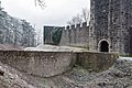
Stone bridge
more pictures
Grave slab Hermann von Stahleck
more pictures
Chapel of St. Boniface
more pictures
Residence A, residential building on the southeast corner, field side
more pictures
Large keep
more pictures
Ansitz B, Münze
further pictures
Antler tower
more pictures
Bergfried
more pictures
Large residential tower
more pictures
Large residential tower
more pictures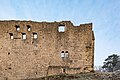
Large residential tower
more pictures
Watchtower
more pictures
Virgin kiss
more pictures
Schäferturm
more pictures


| location | object | description | File no. | image |
|---|---|---|---|---|
| At the Wandelhalle 1, Schlossplatz 5 ( location ) |
Catholic palace chapel Holy Cross | Late Baroque transverse church hall with a gable roof, side tower with onion dome, manorial box extension with pent-hipped roof and with connecting passage to the former castle, by Heinrich Todesco 1773–76; with equipment | D-6-73-114-120 |
 more pictures |
| At the Wandelhalle 1, Schlossplatz 5 ( location ) |
Holy House | With putti canopy, sandstone, 18th century | D-6-73-114-120 |
 more pictures |
| At the Wandelhalle 2 ( location ) |
Corner house | Two-storey solid building with half-hipped roof, inscribed "1794", two-storey residential and commercial building with a mansard roof attached at an angle, Biedermeier front door with skylight, first half of the 19th century | D-6-73-114-121 |
 more pictures |
| Burgstrasse 40, on the footpath to Salzburg ( location ) |
Stone cross | Sandstone, around 1880 | D-6-73-114-245 | |
| Kurhausstraße 31, 33, Schlossplatz 3, 4, Mühlbach, Untere Hinterau ( location ) |
Kurpark, former castle park | A landscaped garden with treetop locations shielded from the site by a walking hall and drinking hall, castle chapel (see at Wandelhalle 1), castle (see Schlossplatz 5) and bathhouse (see Schlossplatz 4), the central area is the oval path of the former castle park in front of the castle and lobby at the end 18th century, remodeling and extensions in the third quarter of the 19th century, the beginning of the 20th century and around 1930 | D-6-73-114-272 |
 more pictures |
| Kurhausstraße 31, 33, Schlossplatz 3, 4, Mühlbach, Untere Hinterau ( location ) |
Kurpark, baroque sculptures | Among other things, putti symbolizing the seasons from the castle park Weisendorf (near Höchstadt) | D-6-73-114-272 |
 more pictures |
| Mühlbach ( location ) |
Kurpark, two-arched stone bridge over the Mühlbach | 19th century | D-6-73-114-272 |
 more pictures |
| Schlossplatz 3, 4 ( location ) |
Kurpark, walking and drinking hall | Two-wing corner building with a round central pavilion, concrete building with a gently sloping hipped roof, inscribed "1929" | D-6-73-114-272 |
 more pictures |
| Untere Hinterau ( location ) |
Kurpark, polygonal music pavilion | Open wooden construction completed by a tent roof, around 1930 | D-6-73-114-272 |
 more pictures |
| Schlossplatz 3, 4 ( location ) |
Former bath house | Single-storey, massive four-wing complex with mansard hipped roofs: broad main wing, connected by two short side wings to the side pavilions of the garden wing towered over by the two-storey central pavilion, neo-baroque, 1906–1908; Garden front related to the Kurpark (see Kurpark) | D-6-73-114-122 |
 more pictures |
| Schlossplatz 5 ( location ) |
Former castle, now a castle hotel | Broad, two-storey building with short side wings and a mansard hipped roof, late Baroque, 1767, by Heinrich Todesco for Egid Borié, two sphinxes on the garden terrace; with equipment; the former palace park is now part of the spa park, cf. there | D-6-73-114-123 |
 more pictures |
Brendlorenzen
| location | object | description | File no. | image |
|---|---|---|---|---|
| Adolf-Johannes-Strasse ( location ) |
Crucifixion group | Sandstone, around 1770 | D-6-73-114-128 | |
| On the Altenberg ( location ) |
The stump of a former guard tower | Natural stone, 15th century | D-6-73-114-175 | |
| An der Linde 11 ( location ) |
Residential building | Two-story saddle roof building with ornamental framework on the upper floor and gable, 18th century | D-6-73-114-127 | |
| Brend, at the so-called weir ( location ) |
Wayside shrine | With Vespers and Coronation of Mary, apostles John and Peter to the side, in a framed cloudy sky with angels, baroque, inscribed "1658" | D-6-73-114-126 | |
| Brückenstraße, at the Sparkasse ( location ) |
Holy House | Sandstone with Michael relief, 1816 | D-6-73-114-138 | |
| Bündstrasse ( location ) |
Holy House | Massive gable roof construction, inside a relief of the risen Lord, 18th century | D-6-73-114-130 | |
| Main street ( location ) |
War memorial for 1870/71 | With crowning statue of Mary, inscribed "1900" | D-6-73-114-137 | |
| Main street ( location ) |
Stone cross | On an inscription base, sandstone, second half of the 19th century | D-6-73-114-139 | |
| Hauptstrasse 37 ( location ) |
Farmhouse | Two-storey, gable-independent saddle roof construction, massive ground floor, ornamental framework on the upper floor and gable, 17th / 18th century. century | D-6-73-114-132 | |
| Hauptstrasse 39 ( location ) |
farm | Two-storey residential building with a gable roof, plastered half-timbering, 17th / 18th centuries. century | D-6-73-114-133 | |
| Hauptstrasse 39 ( location ) |
farm | Courtyard gate, inscribed "1834", with a profiled pointed arch gate 16./17. century | D-6-73-114-133 | |
| Hauptstrasse 41 ( location ) |
Farmhouse | Two-storey gable-roof house, clapboard half-timbering, 18th / 19th centuries century | D-6-73-114-134 | |
| Hauptstrasse 45 ( location ) |
House figure | Saint Joseph, mounted baroque wooden statue, 18th century | D-6-73-114-135 | |
| Hauptstraße, opposite No. 70, junction Adolf-Johannes-Straße ( location ) |
Wayside shrine | Relief with donors under the crucifixion group, on the reverse Johanneshaupt above an inscription, around 1700 | D-6-73-114-158 | |
| Hauptstrasse 114 ( location ) |
House figure | Wooden statue of the Virgin Mary, 18th century | D-6-73-114-141 | |
| Hauptstrasse 118 ( location ) |
Farmhouse | Two-story gable-roof house, massive ground floor, half-timbered upper floor, partly plastered, 18th century, gable side second half of 19th century | D-6-73-114-142 | |
| Hauptstrasse 121 ( location ) |
Farmhouse | Two-storey gable-independent gable roof building, massive ground floor, gable with ornamental framework, 18th century | D-6-73-114-143 | |
| Hauptstrasse 124 ( location ) |
Farmhouse | Gable-independent two-storey saddle roof building, massive ground floor, upper floor plastered half-timbering, 18th century | D-6-73-114-144 | |
| Hauptstrasse 124 ( location ) |
Gate | Inscribed "1822" | D-6-73-114-144 | |
| Hauptstrasse 125 ( location ) |
Farmhouse | Two-storey gable-roof house, massive natural stone-view ground floor, half-timbered upper floor, 18th and 19th centuries | D-6-73-114-145 | |
| Hauptstrasse 127 ( location ) |
Farmhouse | Two-storey, gable-roof construction, plastered half-timbering, 18th century | D-6-73-114-146 | |
| Hauptstrasse 127 ( location ) |
Drilled sandstone gate | Inscribed "1723" | D-6-73-114-146 | |
| Hauptstrasse 127 ( location ) |
Cross tug | Wood, 18th century | D-6-73-114-146 | |
| Hauptstrasse 127, 129 ( location ) |
Courtyard gate with gate | Pillar with pyramidal attachments, sandstone, early 19th century | D-6-73-114-147 | |
| Hauptstrasse 145 ( location ) |
Farmhouse | Two-storey, gable-roof construction, plastered half-timbering, 18th century | D-6-73-114-152 | |
| Hauptstrasse 147 ( location ) |
Farmhouse | Two-storey gable roof building, partly plastered, ornamental framework on the gable side, 18th century | D-6-73-114-153 | |
| Hauptstrasse 149 ( location ) |
Farmhouse | Two-storey gable-roof house, plastered half-timbering, 18th century | D-6-73-114-154 | |
| Hauptstrasse 154 ( location ) |
Gate | With straight lintel, sandstone, inscribed "1851" | D-6-73-114-155 | |
| Hauptstrasse 188 ( location ) |
House figure | Statue of the Virgin, framed in wood, late Gothic | D-6-73-114-157 | |
| Karolingerstraße ( location ) |
Wayside shrine | With late Gothic statue of St. Barbara around 1470/80, sandstone, inscribed "1787" | D-6-73-114-160 |
 more pictures |
| Karolingerstrasse; next to the Barbara wayside shrine ( location ) |
crossroads | Sandstone, inscribed "1865" | D-6-73-114-159 |
 more pictures |
| Karolingerstraße 13 ( location ) |
Catholic Parish Church of St. John Baptista | Choir tower church with transept-like annex buildings open to the nave through arcades, on a cross-shaped floor plan, plastered stone building with gable roof 1125 (dendrochronologically dated) and 1189 (dendrochronologically dated), Carolingian core, choir tower 12./1262 (dendrochronologically dated), on the north side of the choir sacristy, Late Gothic consoles and building inscription on the corner pillar, 1423, interior renovation and roof structure 1711 (dendrochronologically dated) -20, extension of the new sacristy 1971/72, with fittings | D-6-73-114-161 |
 more pictures |
| Near Karolingerstraße ( location ) |
Churchyard wall | Sandstone, 18th century with round arched gate around 1600, part of the wall renewed in 1970 | D-6-73-114-161 |
 more pictures |
| Near Karolingerstraße ( location ) |
Pietà | Baroque, around 1700 over arched gate | D-6-73-114-161 |
 more pictures |
| Near Karolingerstraße ( location ) |
cross | Inscribed "1791", behind Pietà | D-6-73-114-161 |
 more pictures |
| Near Karolingerstraße ( location ) |
Late Gothic Mount of Olives | Sandstone, at its core in 1497, changed when relocated in 1719, relocated to today's location in 1968, with the inscription and two base reliefs replaced by copies | D-6-73-114-161 |
 more pictures |
| Near Karolingerstraße ( location ) |
Way of the Cross | 14 neo-Gothic stations of the cross, sandstone, second half of the 19th century | D-6-73-114-161 |
 more pictures |
| Near Karolingerstraße ( location ) |
War memorial | For the fallen of the two world wars, inscription block crowned by a sculpture of a dying soldier, around 1920/30
in the southern cemetery extension Golgothakreuz, sandstone, from 1833 |
D-6-73-114-161 |
 more pictures |
| Near Karolingerstrasse, in the southern cemetery extension ( location ) |
Golgotha cross | Sandstone, from 1833 | D-6-73-114-161 | |
| Langhans, on the way to Sandheite ( location ) |
crossroads | Sandstone, mid-19th century | D-6-73-114-169 | |
| Langhans; Weg zur Sandheite ( location ) |
Holy House | Pietà inside, solidly plastered, 19th century | D-6-73-114-172 | |
| Leutershauser path; Junction to Fichtig ( location ) |
Wayside shrine | Reliefs: crucifixion group and God the Father, sandstone, inscribed "1620" | D-6-73-114-164 | |
| Leutershauser Strasse 6; Near Leutershauser Straße ( location ) |
Catholic Chapel of St. Lawrence | Late Romanesque choir tower church, plastered solid structure, nave with gable roof, tower with tent roof, mid-13th century | D-6-73-114-162 |

|
| Leutershauser Strasse 6; Near Leutershauser Straße ( location ) |
Gaden wall | With loopholes and pointed arch portal | D-6-73-114-162 |

|
| Near Besengaustraße ( location ) |
crossroads | Sandstone, inscribed "1888" | D-6-73-114-129 | |
| Near Brend; at the Brendbrücke, on the road to Leutershausen ( location ) |
Nepomuk figure | Sandstone, late baroque, inscribed "1750" | D-6-73-114-168 | |
| Near Kreuzmühle; Way to the Kreuzmühle ( location ) |
Wayside shrine | Reliefs: Immaculata, crucifixion group, on the side Saint Martin and Saint Nicholas, sandstone, inscribed "1790" | D-6-73-114-171 | |
| Near Leutershauser Straße, in front of the Laurentiuskirche ( location ) |
Wayside shrine | Classicist, with relief of the Trinity, on the side Saint Urban and Saint Laurentius, sandstone, inscribed "1797" | D-6-73-114-163 |
 more pictures |
| Near Schreiberstrasse; at Münchhausenweg ( location ) |
Holy House | Pietà set in it, limestone, inscribed "1873" | D-6-73-114-173 | |
| Sandheide ( location ) |
Holy House | Probably half-timbered plastered, back with a wooden cross over the ridge, inside reredos with relief of Mary, 19th century | D-6-73-114-174 | |
| on the meadow path ( location ) |
Stone cross | 1637 | D-6-73-114-170 | |
| Stockgasse 8 ( location ) |
Farmhouse | Two-storey gable-independent gable roof building, half-timbered upper floor plastered on the eaves, gable with decorative framework, around 1700 | D-6-73-114-165 | |
| Stockgasse 11 ( location ) |
Courtyard gate of the former castle | Plastered natural stone, 18th century | D-6-73-114-166 | |
| Stockgasse 33 ( location ) |
Garden pavilion | Two-story building, massive ground floor, polygonal plastered half-timbered upper floor, dome roof, around 1780 | D-6-73-114-125 | |
| Stockgasse 33 ( location ) |
Garden wall | With late baroque gate, around 1780 | D-6-73-114-125 | |
| Taubenmühlweg 5 ( location ) |
Former mill | Two-storey half-hipped roof building, ground floor in natural stone, upper floor half-timbered building, 1750/51 (dendrochronologically dated), ground-floor annex on the gable side in natural stone, saddle roof with half-timbered gable, 1597/98 (dendrochronologically dated) | D-6-73-114-242 |
Dürrnhof
| location | object | description | File no. | image |
|---|---|---|---|---|
| Octahedra; on the road to Löhrieth ( location ) |
Floor cross | Sandstone, 19th century | D-6-73-114-178 | |
| Achtäckerweg ( location ) |
Wayside shrine | St. Egidius, sandstone, 1883 | D-6-73-114-177 | |
| Lindenstrasse 12 ( location ) |
Filial church of St. Aegidius | Hall building with retracted choir, saddle roof, hooded roof turret and late baroque gable facade, from 1760; with equipment | D-6-73-114-176 | |
| Christmas tree; on the road to Herschfeld ( location ) |
Wayside shrine | Holy Family, Saints Andreas and Aegidius on the sides, sandstone, inscribed "1743" | D-6-73-114-179 |
Herschfeld
| location | object | description | File no. | image |
|---|---|---|---|---|
| Falltorstraße 9 ( location ) |
farm | Two-storey, gable-independent residential building with half-hipped roof, plastered half-timbering, inscribed "1798", outbuildings partly timber-framed, partly solid with a gable roof | D-6-73-114-181 |
 more pictures |
| Falltorstraße 9 ( location ) |
farm | Courtyard gate, above the classical gate the Saints Sebastian and Wendelin, inscribed "1800" | D-6-73-114-181 |
 more pictures |
| Falltorstraße 11 ( location ) |
Gate | Profiled limestone gate with straight lintel, 18th century | D-6-73-114-182 |
 more pictures |
| Falltorstraße 13 ( location ) |
Courtyard wall with renaissance tomb of Abbot Johannes VIII. Greve von Bildhausen | Relief in an aedicular frame, limestone, 1545 | D-6-73-114-183 |
 more pictures |
| Friedhofstraße, Kirchstraße 3 ( location ) |
crossroads | Stone cross, inscribed "1870" | D-6-73-114-184 |
 more pictures |
| Friedhofstraße, Kirchstraße 3 ( location ) |
Cemetery gate | Pointed arch, natural stone, from 1792 | D-6-73-114-188 |
 more pictures |
| Friedhofstraße, Kirchstraße 3 ( location ) |
War memorial chapel | New Baroque solid building on a square floor plan with a slated hood roof, inside a sculpture of the dead Christ, around 1920 | D-6-73-114-188 |
 more pictures |
| Friedhofstraße, Kirchstraße 3 ( location ) |
Cemetery cross | Around 1900, restored when the cemetery was expanded in 2006 and moved here | D-6-73-114-188 | |
| Gerhart-Hauptmann-Strasse ( location ) |
Wayside shrine with Maria | Anna and Joachim, sandstone plinth with shell-lime attachment, Rococo, inscribed "1764" | D-6-73-114-243 | |
| Kastanienallee ( location ) |
Floor cross | Sandstone, from 1884 | D-6-73-114-185 | |
| Kirchstrasse 16 ( location ) |
Wayside shrine | Reliefs, Vespers, Coronation of Mary, sandstone, baroque, inscribed "1730" | D-6-73-114-189 |
 more pictures |
| Königshofer Straße, at the Saalebrücke ( location ) |
Holy House | With a stone relief of St. Valentin, sandstone, in forms that are still baroque, inscribed "1832" | D-6-73-114-190 | |
| Königshofer Straße 12 ( location ) |
Former Catholic parish church of St. Nicholas | Hall building with a saddle roof from 1825, a medieval tower with an onion hood, large and small lantern, with fittings and fittings | D-6-73-114-192 |
 more pictures |
| Königshofer Straße 12, on the facade ( location ) |
Pillar portal | baroque from Bildhausen, end of 17th century; with equipment | D-6-73-114-192 associated |
 more pictures |
| Königshofer Straße 12 ( location ) |
Churchyard wall | Remains of the churchyard wall with gate from 1696 | D-6-73-114-192 |
 more pictures |
| Königshofer Straße 19 ( location ) |
Gate with curtain arch | Sandstone, 17th century | D-6-73-114-194 | |
| Königshofer Straße 33 ( location ) |
Holy House | Relief stone set into the house wall above balusters, probably from an abbot's tomb from Bildhausen, sandstone, around 1700, inserted here around 1825 | D-6-73-114-197 | |
| Königshofer Straße 27 ( location ) |
Courtyard gate | Solid plastered with gate and figure of saint, 1855 | D-6-73-114-195 |
 more pictures |
| Königshofer Straße 39, 41 ( location ) |
Gate | Round arch, sandstone, inscribed "1700" | D-6-73-114-198 | |
| District road NES 3, on the road to Rödelmaier ( location ) |
Holy House | With Pietà relief, sandstone, inscribed "1860" | D-6-73-114-203 |
 more pictures |
| Liebenthaler Straße, on the road to Rödelmaier ( location ) |
Floor cross | Stone, inscribed "1895" | D-6-73-114-202 | |
| Mühlenweg 15 ( location ) |
Former mill | Courtyard, residential building with half-timbered upper storey and gable roof, second half of the 18th century, the ground floor renewed, with an attached and a free-standing outbuilding, some with remodeling | D-6-73-114-201 | |
| Near Königshofer Straße, in front of the former church ( location ) |
Madonna statue | Light limestone on a high sandstone base, historicist, second half of the 19th century | D-6-73-114-193 |
 more pictures |
| Near Mühlenweg, at the exit to Rödelmaier ( location ) |
chapel | Solid with saddle roof, 1824, inside rococo tomb of Abbot Engelbert Klöpfer von Bildhausen, altar-like with a relief attachment and with an inscription cartouche as an antependium, from 1754 | D-6-73-114-199 |
 more pictures |
| Thüringer Straße, at the exit to Rödelmaier ( location ) |
Wayside shrine | Altar-like with a curved base and rich top, niche with a relief of the Pietà flanked by holy bishops and crowned by Saint Joseph (?), Rococo, sandstone, from 1769 | D-6-73-114-204 | |
| Trail; next to the chapel ( location ) |
So-called plague cross | Sandstone, 17th / 18th centuries century | D-6-73-114-187 | |
| Hiking trail ( location ) |
Wayside chapel | Solid with a gently sloping gable roof, inside a statue of the Virgin Mary, 19th century | D-6-73-114-186 |
Life
Löwenhain Castle Formerly the von Gebsattel castle, after 1919 expansion into a monastery and school by the Congregation of the Holy Family, castle building with courtyard, kitchen and ornamental garden and enclosures with walls, two gates and two pavilions:
- Three- storey main building ( location ) with a hipped roof from 1750, garden-side porch in the middle of the 19th century, two floors of a former tower on a square floor plan, early 16th century, crowning of the battlements in the middle of the 19th century, on the southeast corner of the main building
- Wing building, built in 1750 over basements from 1603, two-storey, in 1929 increased by one storey with a half-hipped roof, to the west in alignment with the main building, with equipment
- neo-baroque chapel, to the west half-hipped roof and dome roof turret, to the east gable roof and apse, 1921, in front of the wing building to the north, with equipment ( location )
- former wash house, sandstone sight, single storey with stepped gables, 1856, next to the courtyard entrance ( location )
- former kitchen garden with wayside cross
- small ornamental garden with curved pathways, probably mid-19th century
- Castle wall and border fences between courtyard and garden areas
- two single-storey pavilions with hipped or tent roofs, 18th century on the castle wall: 1. on the kitchen garden ( location ), 2. on the ornamental garden ( location )
- two gates with heraldic lions, 18th century: 1st courtyard entrance gate ( location ), 2nd gate between courtyard and kitchen garden ( location )
File number: D-6-73-114-208.

Courtyard entrance
Chapel from the north

Wash house

western pavilion

Castle wall, southeast corner


| location | object | description | File no. | image |
|---|---|---|---|---|
| At the old church 1 ( location ) |
Catholic Curate Church of the Birth of the Virgin Mary | Choir tower church, medieval core, tower with pointed helmet, nave with triangular gable and flat gable roof, renewed in 1748; with equipment | D-6-73-114-205 |
 more pictures |
| Blumengartenweg, way to Wollbach ( location ) |
Stone cross | Sandstone, 19th century | D-6-73-114-217 |
 more pictures |
| Blumengartenweg, Brendfeld ( location ) |
Wayside shrine | Relief Mary with child as a half figure, sandstone, 1911 | D-6-73-114-219 | |
| Brender Weg, Ziegeleiweg ( location ) |
graveyard | With stone wall 19th century | D-6-73-114-257 |
 more pictures |
| Brender Weg, Ziegeleiweg ( location ) |
War memorial | For the fallen of the two world wars, crucifix and inscription tablets, around 1960 | D-6-73-114-257 | |
| Brender Weg, Ziegeleiweg ( location ) |
Two grave slabs | With ancestral coat of arms, 1859 and 1861 | D-6-73-114-257 | |
| Büchelberg, road to Wollbach ( location ) |
Stone cross | Niche with IHS symbol on the base of the cross, donor inscription on the base, inscribed "1899" | D-6-73-114-215 | |
| Neugereut, road to Schweinhof ( location ) |
Wayside shrine | Reliefs Coronation of Mary and Mary with Child, saints on the side, base with banding, 18th century | D-6-73-114-223 |
 more pictures |
| Roast, Flurweg to Wollbach ( location ) |
Stone cross | Artificial stone, probably first quarter of the 20th century | D-6-73-114-216 | |
| Schönauer Weg 1 ( location ) |
Holy House | Sandstone, inscribed "1887" | D-6-73-114-222 |
 more pictures |
| Schweinhofer Straße 9 ( location ) |
Former school | Two-story hipped roof building, around 1830 | D-6-73-114-209 |
 more pictures |
| Schweinhofer Straße 9 ( location ) |
= Former stables of the castle | Second half of the 19th century, single-storey plastered brick building with stepped gable, converted into an inn in 1920 | D-6-73-114-345 |
 more pictures |
| Schweinhofer Strasse 27 ( location ) |
House figure | Madonna, 18th century | D-6-73-114-210 | |
| Trieb, road to Schweinhof ( location ) |
Wayside shrine with crucifixion group | Back with inscription, inscribed "1718" | D-6-73-114-221 | |
| Ziegeleiweg, at the cemetery ( location ) |
Holy House | With group of figures, lamentation under the cross, 17th century | D-6-73-114-214 |
 more pictures |
Löhrieth
| location | object | description | File no. | image |
|---|---|---|---|---|
| Bildhauser Strasse 10 ( location ) |
Farmhouse | Two-storey, gable-independent house with a gable roof, decorative framework plastered over, inscribed "1799" | D-6-73-114-226 | |
| Bildhauser Strasse 32 ( location ) |
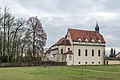
Catholic branch church St. Jakobus Major | Massive late baroque hall building with retracted choir, saddle roof, canopy roof turret, 1754; with equipment | D-6-73-114-229 |
 more pictures |
| Bildhauser Strasse; Near Bildhauser Strasse ( location ) |
War memorial | Crucifix made of stone with a body on a cross made of tree trunks, around 1920, in front of it two plaques of honor for those who died in the two world wars | D-6-73-114-270 | |
| Tannenstrasse ( location ) |
Wayside shrine | Top with paw cross, sandstone, inscribed "1726" (with Madonna relief added later) | D-6-73-114-228 |
 more pictures |
Mühlbach
| location | object | description | File no. | image |
|---|---|---|---|---|
| Bildhauser Berg ( location ) |
Cemetery cross | Sandstone, inscribed "1812" in front of two walled up tombstones from the 19th century | D-6-73-114-234 | |
| Corner of Brunnenweg, Mühlberg ( location ) |
Wayside shrine | Ornamental-three-dimensional shaft made of rocailles, above it a relief with a crucifixion group, Vespers on the back, passion scenes on the side, third quarter of the 18th century | D-6-73-114-233 | |
| Grasberg ( location ) |
Wayside shrine | Reliefs: Coronation of the Virgin Mary and Kreuzschlepper, Rococo, 18th century | D-6-73-114-237 | |
| Hohengrube; at the Saalebrücke ( location ) |
Nepomuk figure | Sandstone, baroque, 18th century | D-6-73-114-236 | |
| Kurhausstrasse 1 ( location ) |
Catholic Curate of the Holy Family | Community center, two- to four-storey building group with mansard hipped roof and gable roof, above the basilical church with choir and vestibule roof turret with stepped onion dome, side aisle with pent roof, 1925; with equipment | D-6-73-114-230 |
 more pictures |
| Kurhausstrasse 2 ( location ) |
Farmhouse | Two-storey gable-independent half-hipped roof house, plastered half-timbering, drilled front door frame, 17th / 18th century. century | D-6-73-114-231 | |
| Kurhausstrasse 14 ( location ) |
farm | With a two-storey, gable-independent residential house, plastered half-timbering, gable roof, 17th / 18th centuries. century | D-6-73-114-232 | |
| Mühlbacher Bach; Road to Löhrieth ( location ) |
Floor cross | Sandstone, inscribed "1852" | D-6-73-114-235 |
Schweinhof
The hamlet of Schweinhof is in the Lebenhan district.
| location | object | description | File no. | image |
|---|---|---|---|---|
| B 279 ( location ) |
milestone | Sandstone, third quarter of the 19th century | D-6-73-114-276 | |
| District road NES 14, on the road opposite the hamlet of Schweinhof ( location ) |
Stone cross | Sandstone, from 1856 | D-6-73-114-241 |
 more pictures |
| District road NES 14, on the road to B 279 ( location ) |
Cross tug | Sandstone, inscribed "1772" | D-6-73-114-240 |
 more pictures |
| Schweinhof 2 ( location ) |
farm | Two-storey massive house on an angular floor plan, with hip and stepped gable, connected to the adjoining outbuilding with a gable roof, 1857/59, house figure 18th century | D-6-73-114-238 |
Former architectural monuments according to districts
This section lists objects that were previously entered in the list of monuments.
Bad Neustadt an der Saale
| location | object | description | File no. | image |
|---|---|---|---|---|
| Bauerngasse 14 ( location ) |
Residential building | Two-storey gable roof structure, plastered ornamental framework, with profiled floor overhangs and carved (foliage and volutes) corner posts, courtyard side arcade, 1618 (dendrochronologically dated), gable end 1873 (dendrochronologically dated) widened | D-6-73-114-19 | |
| Bauerngasse 14 ( location ) |
rear annex | Ground floor and basement made of quarry stone, on the ground floor round arched walls, 14th century, in the basement a pointed arch portal with pear rod profile | D-6-73-114-19 | |
| Hohnstrasse 31 ( location ) |
Residential and commercial building | Two-storey eaves half-hipped roof building, massive ground floor, side baroque window frames, half-timbered upper floor plastered, 18th century | D-6-73-114-38 |
 more pictures |
| Hohnstrasse 37 ( location ) |
Old office building | Massive plastered gable roof building with pilaster structure, ground floor with drilled door and window walls, 18th century, upper floor 19th century | D-6-73-114-40 |

|
| Mühlbacher Strasse ( location ) |
Wayside shrine | 18th century | D-6-73-114-71 | |
| Storchengasse 13 ( location ) |
stone | Inscribed "1550"; walled in | D-6-73-114-116 |
Life
| location | object | description | File no. | image |
|---|---|---|---|---|
| Blumengartenweg ( ) |
crossroads | Second half of the 19th century | D-6-73-114-220 | |
| Schweinhofer Strasse 36 ( location ) |
Former farm building and inn | Two-storey saddle roof building in plastered half-timbering, 17th century | D-6-73-114-211 |
Lost monuments
This section lists objects that were previously entered in the list of monuments, but no longer exist.
| location | object | description | File no. | image |
|---|---|---|---|---|
| Bad Neustadt an der Saale An der Stadthalle 4 ( location ) |
City Hall | Wide-spread post-war modern building with a sloping hipped roof and entrance porch, roof turret with filigree lantern, scratched plaster relief, open staircase and concrete edging of the green spaces in front, by Konrad Wiesner 1956; Demolition 2014 | D-6-73-114-265 |
 more pictures |
| Brendlorenzen Hauptstraße 132 ( location ) |
Farmhouse | Two-storey gable roof building, plastered half-timbering, 18th century | D-6-73-114-148 | |
| Brendlorenzen Hauptstraße 133 ( location ) |
Farmhouse | Two-storey gable-roof house, plastered half-timbering, 17th / 18th centuries century | D-6-73-114-149 | |
| Bad Neustadt an der Saale Hohnstrasse 35 ( location ) |
Gasthof Schwan and Post | Three-storey, gable-independent auxiliary building in plastered half-timbering, with courtyard gate, 18th century; In 2017 the building at Hohnstrasse 31 and then the building between the Gasthof Schwan and Post were demolished | D-6-73-114-39 |
 more pictures |
| Herschfeld Königshofer Straße 32 ( location ) |
Gate with a straight lintel | Limestone, 18th century | D-6-73-114-196 | |
| Herschfeld Liebenthaler Straße ( location ) |
Holy House | By 1893 | D-6-73-114-200 |
See also
Remarks
- ↑ This list may not correspond to the current status of the official list of monuments. The latter can be viewed on the Internet as a PDF using the link given under web links and is also mapped in the Bavarian Monument Atlas . Even these representations, although they are updated daily by the Bavarian State Office for Monument Preservation , do not always and everywhere reflect the current status. Therefore, the presence or absence of an object in this list or in the Bavarian Monument Atlas does not guarantee that it is currently a registered monument or not. The Bavarian List of Monuments is also an information directory. The property of a monument - and thus the legal protection - is defined in Art. 1 of the Bavarian Monument Protection Act (BayDSchG) and does not depend on the mapping in the Monument Atlas and the entry in the Bavarian Monument List. Objects that are not listed in the Bavarian Monument List can also be monuments if they meet the criteria according to Art. 1 BayDSchG. Early involvement of the Bavarian State Office for Monument Preservation according to Art. 6 BayDSchG is therefore necessary in all projects.
literature
- Denis André Chevalley: Lower Franconia . Ed .: Michael Petzet , Bavarian State Office for the Preservation of Monuments (= Monuments in Bavaria . Volume VI ). Oldenbourg, Munich 1985, ISBN 3-486-52397-X .
Web links
- Bavarian Monument Atlas (cartographic representation of the Bavarian architectural and ground monuments by the Bavarian State Office for Monument Preservation (BLfD) )
- List of monuments for Bad Neustadt an der Saale (PDF) at the Bavarian State Office for Monument Preservation
Individual evidence
- ↑ Expert opinion of Herbert Architects, Buchholz + Platzöder, Hohenroth-Leutershausen, November 27, 2001

Aubstadt | Bad Königshofen im Grabfeld | Bad Neustadt an der Saale | Bastheim | Bischofsheim in the Rhön | Burglauer | Fladungen | Großbardorf | Großeibstadt | Hausen | Hendungen | Herbstadt | Haystack | Höchheim | Hohenroth | Hollstadt | Mellrichstadt | Niederlauer | Nordheim before the Rhön | Oberelsbach | Top litter | Ostheim before the Rhön | Rödelmaier | Hall on the Saale | Salt | Sandberg | Schönau an der Brend | Sondheim before the Rhön | Stockheim | Radiations | Sulzdorf an der Lederhecke | Sulzfeld | Trappstadt | Unsleben | Willmars | Wollbach | Wülfershausen on the Saale