
List of architectural monuments in Fladungen

The monuments of the Lower Franconian town of Fladungen are compiled on this page . This table is a partial list of the list of architectural monuments in Bavaria . The basis is the Bavarian Monument List , which was first drawn up on the basis of the Bavarian Monument Protection Act of October 1, 1973 and has since been managed by the Bavarian State Office for Monument Preservation . The following information does not replace the legally binding information from the monument protection authority. This list reflects the update status as of April 7, 2020 and contains 121 architectural monuments.
Ensembles
Old town Fladungen

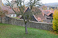
The Fladungen, first mentioned in a document in 787, received city rights in 1335, whereupon the place was fortified in an approximately square outline. In the arable and craft town , the agricultural component predominates, which is why the town plan lacks certain urban features. Instead of its own market square , the center takes up an extensive, diamond-shaped block of houses. The two streets around it connect the upper and lower city gates. The side streets have the character of village connecting paths. A city stream runs through the town from west to east, which originally operated the mills of the craftsmen. While the inner structure was created at the end of the 16th century, the building stock is made up of half-timbered houses from the 17th / 18th centuries due to the city fire in 1635. Century. On narrow, deep plots of land, small farms are lined up side by side, the houses of which are partly on the eaves and partly on the gable side. The saddle-roof houses, all of which are half-timbered and often plastered, are characterized by clearly structured, rhythmic facades, some of which have special decorative shapes on their corner posts, the so-called scare heads. The buildings of the former Würzburg office building of the Fladungen office and the parish church on the south-eastern outskirts stand in contrast to the fragmented nature of the urban structure . The former Würzburg official building, built under Prince-Bishop Julius Echter von Mespelbrunn , consists of two wings that meet at right angles and that delimit a square. Immediately behind it, in its own churchyard district, is the parish church. Boundary: city wall. File number E-6-73-123-1.
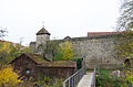
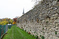
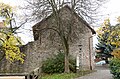
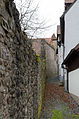
City fortifications Fladungen
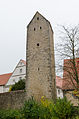
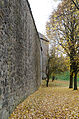
The city fortifications began around 1335. The wall is complete, three of the 16 rider towers that were once attached to it have been preserved. The four defense towers are:
- in the northwest Vexier Tower, a round tower with a Welscher hood from 1601
- on the west side by the Thürnersturm mill, on a square floor plan
- on the south side of the Jakob tower, square floor plan
- on the south side at the Pulverturm parish church, square floor plan, raised in 1595
File number: D-6-73-123-1. Pictures .
City wall course from the Maulaffe Tower to the breakthrough at the lower gate.

Mouth monkey tower, field side

Wall at Dr.-Höffling-Strasse

Wall at Dr.-Höffling-Strasse

Reiterturm

Wall at Dr.-Höffling-Strasse

Wall at Badergasse

Reiterturm
Wall at Badergasse

Reiterturm
Wall at Badergasse


City wall course from the Maulaffenturm from the breakthrough at the lower gate to Bahnhofstrasse.
Wall at Badergasse
Wall at Badergasse

Reiterturm


City wall course from St. Kilian to Ludwigstrasse.

archway

Powder tower
Powder tower

South side
South side

Jacob Tower
Between Thürnersturm and Jakobturm

Between Thürnersturm and Jakobturm

Thürnersturm

West side

Vexier and wall


Of the two gate systems, only the so-called mouth monkey tower remains at the former northern or upper gate.
| location | object | description | File no. | image |
|---|---|---|---|---|
| Near Obere Torgasse ( location ) |
Obertorturm or Maulaffenurm | City gate tower on a square floor plan with side stair tower, around 1335 and inscribed "1560" | D-6-73-123-128 |
 more pictures |
Fortification Heufurt
The Heufurt fortification is probably of post-medieval origin. Remnants of the west train are along Frankenstraße at No. 2–12 (straight) with entry at Jakobusstraße. The remains of the southern train are preserved at Frankenstrasse 2 and Nikolausstrasse 10. A remnant of the north train is available at Frankenstrasse 12. File number: D-6-73-123-61.
Fortification of Oberfladungen
The fortification of Oberfladungen probably dates from the 16th century. Fragments of the wall have been preserved around the place, continuing the churchyard wall to the north and behind Webergasse 2, 4, 6 running to the north of Eisenacher Strasse 1. File number: D-6-73-123-83.
Architectural monuments according to districts
Fladungen
| location | object | description | File no. | image |
|---|---|---|---|---|
| Badergasse 1 ( location ) |
Half-timbered house | Eaves on a stone base, two-storey, with boarded gable, 17th / 18th century century | D-6-73-123-2 |
 more pictures |
| Badergasse 1 ( location ) |
Half-timbered outbuildings | Belonging | D-6-73-123-2 |
 more pictures |
| Badergasse 2 ( location ) |
pharmacy | Gable roof house with ornamental framework, 17th / 18th centuries century | D-6-73-123-3 |
 more pictures |
| Bahnhofstrasse 9 ( location ) |
Saint figure | Life-sized Christ as a good shepherd, 18th century | D-6-73-123-4 | |
| Bahnhofstrasse 16 ( location ) |
Art Nouveau villa | At the top of the gable, one storey with a steep mansard roof with dormer windows, 1911 | D-6-73-123-5 | |
| Bahnhofstrasse 19; At the train station ( location ) |
railway station | Two-storey main building with half-hipped roof, polygonal masonry with brick walls, historicist in the Swiss style, 1899 | D-6-73-123-106 |
 more pictures |
| Bahnhofstrasse 19; At the train station ( location ) |
Goods shed | historicist in Swiss style, 1899 | D-6-73-123-106 |
 more pictures |
| Bahnhofstrasse 19; At the train station ( location ) |
railway station | One-storey outbuilding, 1899 | D-6-73-123-106 | |
| Bahnhofstrasse 25 ( location ) |
Former locomotive shed and service apartment building at the station | Elongated one-storey building in polygonal masonry and brick walls, flat gable roof, built in 1899, at the same time and in the same style as the other station buildings (see Bahnhofstrasse 19) | D-6-73-123-107 |
 more pictures |
| Brüchser Strasse; Exit to Brüchs ( location ) |
Stone cross | Marked "1900", restored in 1982 | D-6-73-123-43 |
 more pictures |
| Brunnengasse 5 ( location ) |
House figure | 18th century | D-6-73-123-6 | |
| Carl-Josef-Sauer-Strasse ( location ) |
Stone cross | 1909 | D-6-73-123-7 |
 more pictures |
| Open Air Museum ( location ) |
Outer mill, so-called Reßmühle | Half-timbered building, partly clapboard, with half-hipped mansard roof, 1803 | D-6-73-123-40 |
 more pictures |
| Dr.-Höffling-Strasse ( location ) |
Market fountain | 19th century iron column, stone basin marked "1777" | D-6-73-123-32 | |
| Dr.-Höffling-Strasse 1 ( location ) |
Former beneficiary hospital | Stately two-story saddle-roofed house with ornamental framework, 1770–74, weather vane marked “1747”, front door around 1870 | D-6-73-123-8 |
 more pictures |
| Dr.-Höffling-Strasse 2 ( location ) |
Gasthaus zum Löwen | Gable roof house with half-timbered upper floor, 18th century | D-6-73-123-9 |
 more pictures |
| Dr.-Höffling-Strasse 4 ( location ) |
Eaves side house with gate entrance | Plastered half-timbering, 18th century | D-6-73-123-10 | |
| Dr.-Höffling-Straße 6 ( location ) |
Gable roof house | Eaves, two-storey, plastered half-timbering, 17th century | D-6-73-123-11 |
 more pictures |
| Dr.-Höffling-Straße 8 ( location ) |
Corner house | Two-storey, decorative framework under the plaster, 17th century | D-6-73-123-12 |
 more pictures |
| Dr.-Höffling-Straße 9 ( location ) |
Gable roof house | Two-storey, with exposed half-timbering, 17th / 18th centuries Century, front door first half of the 19th century | D-6-73-123-13 |
 more pictures |
| Dr.-Höffling-Straße 11 ( location ) |
Gable roof house | Two-storey, plastered framework, a corner post exposed, 17th / 18th century. century | D-6-73-123-14 |
 more pictures |
| Dr.-Höffling-Straße 14 ( location ) |
Immaculata | Mounted wooden statue and three seraphim heads, 18th century | D-6-73-123-15 |
 more pictures |
| Dr.-Höffling-Straße 17 ( location ) |
Gable roof house | With exposed half-timbered upper floor, marked "1713" | D-6-73-123-16 |
 more pictures |
| Dr.-Höffling-Straße 19 ( location ) |
Gable roof house
Article = |
At the top of the gable, two-storey with exposed framework, 17th / 18th century. century | D-6-73-123-17 |
 more pictures |
| Dr.-Höffling-Straße 21 ( location ) |
Residential building | Corner building with exposed half-timbering on the upper floor, 18th century, semi-detached house with Ludwigstraße 26 | D-6-73-123-18 |
 more pictures |
| Dr.-Höffling-Straße 28, 30 ( location ) |
Duplex | Eaves with exposed half-timbering, carved corner posts, 18th century | D-6-73-123-19 |
 more pictures |
| Dr.-Höffling-Straße 34 ( location ) |
Gable roof house | Plastered framework, 17th / 18th centuries century | D-6-73-123-20 |
 more pictures |
| Near Hausener Strasse ( location ) |
Wayside chapel | Inscribed "1774", with a relief from the 19th century, as Station I of the Way of the Cross to the Gangolf Chapel | D-6-73-123-114 | |
| Kapellenberg; in front of the Gangolf Chapel ( location ) |
Wayside shrine | Four reliefs on the case (crucifixion group, crescent moon Madonna, St. Gangolf and a holy bishop), inscribed "1626" | D-6-73-123-49 | |
| Kapellenberg; in front of the Gangolf Chapel ( location ) |
Cemetery cross with assistant figures | 1774, at the same time station XII of the Way of the Cross to the Gangolf Chapel | D-6-73-123-48 | |
| Kapellenberg ( location ) |
Catholic Chapel of St. Gangolf | Hall building with a second floor as a bell chamber, semicircular apse, 1597; with equipment | D-6-73-123-46 |

|
| Kapellenberg ( location ) |
Mary's Grotto | With altar niche and standing stone figure of Mary, 20th century, in front of the Gangolf chapel | D-6-73-123-125 | |
| Kapellenberg; St. Gangolf Path; Near St.-Gangolf-Weg ( location ) |
Way of the Cross to the Gangolf Chapel | 1744, reliefs partially renewed in the 19th century (belonging to Hausener Straße, Wegkapelle as station I and crucifixion group in the churchyard of the Gangolf chapel)
as station XII |
D-6-73-123-47 | |
| Kirchberg; Oberfladunger Straße, on the Oberfladunger Berg ( location ) |
Stone cross | Second half of the 19th century | D-6-73-123-51 | |
| Leubachsgraben; Near Brüchser Strasse; Oberfladunger Straße ( location ) |
bridge | Single-bay stone arch bridge with stone parapet, probably early 19th century. | D-6-73-123-185 | |
| Leubachspfad; Exit after overburden ( location ) |
Stone cross | 19th century | D-6-73-123-44 | |
| Ludwigstrasse 1 ( location ) |
Catholic parish church of St. Kilian | Choir tower church in partly Gothicized forms, rebuilt on a medieval basis 1657–59, with the addition of the south aisle; with equipment | D-6-73-123-21 |
 more pictures |
| Ludwigstrasse 1 ( location ) |
Churchyard wall | Rebuilt in 1643, see city fortifications | D-6-73-123-21 |
 more pictures |
| Ludwigstrasse 2 ( location ) |
Gable roof house | Two-storey corner house, plastered half-timbering, 18th century | D-6-73-123-22 |
 more pictures |
| Ludwigstrasse 3; Near Bahnhofstrasse ( location ) |
graveyard | 17./18. Century, extended to the south around 1900 | D-6-73-123-115 | |
| Ludwigstrasse 3; Near Bahnhofstrasse ( location ) |
graveyard | Sandstone crucifix, around 1900 | D-6-73-123-115 | |
| Ludwigstrasse 3; Near Bahnhofstrasse ( location ) |
graveyard | Northern cemetery wall 17th / 18th centuries Century, southern around 1900 | D-6-73-123-115 |
 more pictures |
| Ludwigstrasse 3; Close to Bahnhofstrasse, walled into the outer wall facing Ludwigstrasse ( location ) |
graveyard | Round-arched three-part relief with Pietà, crucifixion and risen Christ, 16th century | D-6-73-123-115 |
 more pictures |
| Ludwigstrasse 3; Close to Bahnhofstrasse, walled into the outer wall facing Ludwigstrasse ( location ) |
graveyard | Late Gothic keel arch niche with bracing | D-6-73-123-115 |
 more pictures |
| Ludwigstrasse 10 ( location ) |
Construction on the eaves | With solid ground floor and half-timbered upper floor, 18th / 19th century | D-6-73-123-23 | |
| Ludwigstrasse 13 ( location ) |
Former post office | Two-storey, two-wing corner building with gable roofs, large half-timbered gable and roof turrets with clock tower, around 1925 | D-6-73-123-129 |
 more pictures |
| Ludwigstrasse 25, 27 ( location ) |
Duplex | Half-timbered upper floor, 18th century | D-6-73-123-24 |
 more pictures |
| Ludwigstrasse 26 ( location ) |
Eaves half-timbered building | First half of the 19th century, with a front door from the building period; Semi-detached house with Dr.-Höffling-Straße 21 (see there) | D-6-73-123-25 | |
| Ludwigstrasse 29 ( location ) |
Plastered half-timbered house | With neo-Gothic decor, 17th to second half of the 19th century | D-6-73-123-26 | |
| Ludwigstrasse 30; Ludwigstrasse 32 ( location ) |
Duplex | Decorative framework under the plaster, marked "1665" | D-6-73-123-27 | |
| Ludwigstrasse 30; Ludwigstrasse 32 ( location ) |
Immaculata | 18th century | D-6-73-123-27 | |
| Ludwigstrasse 33 ( location ) |
Half-timbered house | Two-storey with a solid ground floor and a gable roof, on the gable side with rich diamond decorations, 17th / 18th century. century | D-6-73-123-28 |
 more pictures |
| Ludwigstrasse 35, 37 ( location ) |
Duplex | Two-storey, decorative framework under the plaster, 17th century | D-6-73-123-29 |
 more pictures |
| Marketplace 1, 2 ( location ) |
Former tithe house, now town hall and Rhön Museum | Three-storey massive two-wing building with volute gable, 1601–26 | D-6-73-123-30 |
 more pictures |
| Marketplace 3 ( location ) |
Half hipped roof house | Half-timbered upper floor, around 1800, on the gable Immaculata | D-6-73-123-31 |
 more pictures |
| Mühlgasse 4 ( location ) |
Community bake house | Two-storey saddle-roof house, exposed half-timbering, end of the 18th century | D-6-73-123-33 | |
| Near Bahnhofstrasse, at the train station on the exit to Heufurt ( location ) |
Stone cross | 1877 | D-6-73-123-45 | |
| Near Hausener Strasse ( location ) |
War memorial | In the form of a fountain, fountain stick with putti, octagonal fountain basin, inscribed "1923" | D-6-73-123-126 |
 more pictures |
| Near Hausener Strasse ( location ) |
Wayside chapel | Inscribed "1774" with a relief from the 19th century | D-6-73-123-114 | |
| Near district road NES 30; Road to Sands ( location ) |
Wayside shrine | On the front and back of the case reliefs of the crucifixion and lamentation, on the side donors under the crucifix and inscription, inscribed "1622" | D-6-73-123-50 | |
| Near Weihersweg; on Lerchenweg, at the Weihersweg intersection ( location ) |
Wayside shrine | Crucifixion relief, probably 17th century | D-6-73-123-53 | |
| Obere Brückengasse 1 ( location ) |
Half-timbered house | Gable end, 18./19. century | D-6-73-123-34 | |
| Upper gate 7 ( location ) |
Eaves side house | Plastered two-storey half-timbered building, 17th century | D-6-73-123-35 | |
| Upper gate 9 ( location ) |
Gable roof house | Plastered framework, 17th / 18th centuries century | D-6-73-123-36 | |
| Upper gate 11 ( location ) |
Gable roof house | With half-timbered upper floor, marked 1669 | D-6-73-123-37 |
 more pictures |
| Upper gate 12 ( location ) |
Eaves side house | Half-timbered, 17th century | D-6-73-123-38 | |
| Lower gate ( location ) |
Running fountain | Cast iron well stock with stone trough, second half of the 19th century | D-6-73-123-39 | |
| Battlement 1 ( location ) |
Gable roof house | Half-timbered upper floor exposed, 17./18. century | D-6-73-123-41 |
 more pictures |
| Battlement 2 ( location ) |
Upper mill | Half-hipped roof house, ornamental framework, inscribed "1708" | D-6-73-123-42 |
 more pictures |
| Weihersweg 20, at the Weihersmühle ( location ) |
Wayside shrine | With Vesper picture, probably 19th century | D-6-73-123-52 |
Brittle
| location | object | description | File no. | image |
|---|---|---|---|---|
| Mountain field; at the cemetery ( location ) |
Wayside shrine | Maybe 19th century | D-6-73-123-55 | |
| Friedhofstrasse 12; in the cemetery ( location ) |
Cemetery cross | 1892 | D-6-73-123-54 | |
| In Bruchs; at the church on the outskirts of Fladungen ( location ) |
Stone cross | 1843 | D-6-73-123-59 | |
| In Bruchs; Lindenstrasse 18 ( location ) |
Wayside shrine | With a relief of a holy bishop, probably 18th century | D-6-73-123-58 | |
| Langenstreich; at the northern exit of the town ( location ) |
Stone cross | Base with figure of Mary, 1902, cross with body around 1925 | D-6-73-123-108 | |
| Lindenstrasse 1 ( location ) |
Catholic parish church of St Anton | Barrel-vaulted hall with a steep gable roof, distinctive corner tower set to the side of the main entrance with a tapered bonnet, quarry stone, 1923 (laying of the foundation stone) to 1926 (consecration); with equipment | D-6-73-123-56 |

|
| Lindenstrasse 6 ( location ) |
Former Catholic Church of St. Anton | Simple hall building with slated onion-hood ridge and retracted choir, marked 1729 | D-6-73-123-57 |
Hayurt
| location | object | description | File no. | image |
|---|---|---|---|---|
| B 285; Road to Nordheim ( location ) |
Cross tug | 1720 | D-6-73-123-72 |

|
| Frankenstrasse 5 ( location ) |
Residential building | On top of the gable, two-story with decorative framework and two figuratively carved corner posts, 17th century | D-6-73-123-62 | |
| Behind the village; Bahnhofweg ( location ) |
Wayside shrine | In the case reliefs (Arma Christi and crucifixion group), saints and angels on the side, inscribed "1687" | D-6-73-123-70 | |
| In Heufurt ( location ) |
Wayside shrine | In the case the crucifixion group, on the column with Corinthian capital the coat of arms of Prince-Bishop Julius Echter, 1616 | D-6-73-123-64 | |
| In hayurt; Kirchsteig 7 ( location ) |
Catholic branch church St. Jakobus Major | Hall building with retracted polygonal choir and tower on the side of the choir, tower, choir and sacristy medieval, stair tower around 1600, nave renovated 1708-10; with equipment | D-6-73-123-65 |

|
| In hayurt; Kirchsteig 7 ( location ) |
Churchyard wall | D-6-73-123-65 | ||
| Jakobusstraße 1 ( location ) |
Half-timbered house | Two-story, with male figures at the gable, 17th century | D-6-73-123-63 | |
| Kirchsteig 1, below the church ( location ) |
Storage cellar | Quarry stone buildings, 16./17. Century | D-6-73-123-134 | |
| Kirchsteig 5 ( location ) |
school | Two-storey with a gable roof, built in 1748, extended and redesigned in 1875, front door leaf with tracery cassettes in 1875 | ||
| Kirchsteig 7; in the cemetery ( location ) |
Cemetery cross | At the same time Station XII of the Way of the Cross, 1860 | D-6-73-123-66 | |
| Obere Dorfgasse 2 ( location ) |
Coat of arms of Prince-Bishop Julius Echter | Inscribed "1614" (town hall) | D-6-73-123-67 | |
| Unterhofstatt; Exit to Nordheim ( location ) |
Wayside shrine | Elaborately crafted, case with reliefs (Holy Family and Coronation of the Virgin Mary) and on the side with saints, vine-covered column with angel heads in the capital, inscribed "1695" | D-6-73-123-71 |

|
| Divide; Exit to the south ( location ) |
Wayside shrine | Two reliefs on the case (crucifixion group and Arma Christi), 1760 | D-6-73-123-69 |

|
| Wendelinusweg; Exit after Fladungen ( location ) |
Crucifixion group | 1903 | D-6-73-123-68 |
 more pictures |
Huflar
| location | object | description | File no. | image |
|---|---|---|---|---|
| In Huflar ( location ) |
Old castle | Two-storey stone building from 1597 to 1599 | D-6-73-123-73 | |
| In Huflar ( location ) |
Old castle | Circular wall with gate from 1801 | D-6-73-123-73 | |
| In Huflar ( location ) |
Garden pavilion | Polygonal with a short entrance porch around 1800, from the former New Palace | D-6-73-123-73 |
Leubach
| location | object | description | File no. | image |
|---|---|---|---|---|
| Bachäcker; south of Frankenheimer Straße near the ponds ( location ) |
Wayside shrine | Relief in rococo forms with a crucifixion group, inscribed "1848" | D-6-73-123-80 | |
| Frankenheimer Strasse ( location ) |
Stone crucifix | Historicist, 1909 | D-6-73-123-78 | |
| Frankenheimer Straße 7 ( location ) |
Wayside shrine | With crucifix relief, 1743 | D-6-73-123-74 | |
| Frankenheimer Straße 12 ( location ) |
Upper bridge | One-bay arch bridge, sandstone cuboid, around 1840 | D-6-73-123-109 | |
| Leiboldstrasse 1 ( location ) |
Wayside shrine | With relief of Saint Wendelin, 1743 | D-6-73-123-75 | |
| Leiboldstrasse 5 ( location ) |
Catholic Curate Church of St. Vitus | Hall building with tower facade and retracted nave-high choir, inscribed "1795"; with equipment | D-6-73-123-76 |

|
| Leubach; Rhönstrasse ( location ) |
Lower bridge | One-bay arch bridge, sandstone cuboid, around 1840 | D-6-73-123-110 | |
| Near Leiboldstrasse ( location ) |
Cemetery cross | With rococo ornamentation, 1846; in the cemetery | D-6-73-123-77 | |
| Temple; on a pasture approx. 600 meters northeast of the church ( location ) |
temple | With Madonna, neo-Gothic, 1892 | D-6-73-123-79 | |
| Todenwald ( location ) |
Atonement Cross | With fragmentary inscription, 1703, in the forest of the dead | D-6-73-123-82 |
Overloads
| location | object | description | File no. | image |
|---|---|---|---|---|
| At the Heiligenpfad ( location ) |
Wayside shrine | The crucifixion group set in white stone in the case, behind the relief of the donor kneeling before the crucifix, 1885 | D-6-73-123-89 | |
| Eisenacher Strasse 2a ( location ) |
Wayside shrine | With four Passion reliefs, on a fitting base, sandstone, second half of the 16th or 17th century; at the junction of the B 285 to the border to Thuringia | D-6-73-123-88 | |
| Hauptstrasse 32 ( location ) |
town hall | In the local style, massive ground floor, half-timbered upper floor, around 1925 | D-6-73-123-124 | |
| Hauptstrasse 41; Kirchberg 12; Close to main road; at the churchyard wall ( location ) |
Lourdes grotto | With two stone figures of Maria and Bernadette, erected in 1897 | D-6-73-123-112 | |
| Huflarer Weg; Junction to Huflar ( location ) |
signpost | “To Huflar 1.8 kilometers”, around 1870 | D-6-73-123-93 | |
| Huflarer Weg 6; Exit to Huflar ( location ) |
Stone cross | Inscribed "1842" | D-6-73-123-92 | |
| In overburden; Field side of the churchyard wall ( location ) |
Stations of the Cross | In an altar-like shape, gabled stone relief on a table-like base, sandstone, 1900; not re-qualified | D-6-73-123-90 | |
| In overburden; between 13th and 14th stations of the cross ( location ) |
Wayside shrine | With four evangelist reliefs, inscribed "1684" | D-6-73-123-91 | |
| Kirchberg ( location ) |
War memorial for the fallen soldiers of the First World War | Obelisk with a lion sculpture, 1920s | D-6-73-123-122 | |
| Kirchberg 8, 10 ( location ) |
Duplex | Two-storey eaves gable roof construction, upper floor half-timbered, labeled "1849", with raised access | D-6-73-123-84 | |
| Kirchberg 10 ( location ) |
Duplex | Residential house, two-storey half-timbered building over a solid base, with a gable roof and carved door, around 1800 | D-6-73-123-189 | |
| Kirchberg 12 ( location ) |
Rectory | Two-storey saddle roof building with half-timbered upper storey, around 1700, with an older core | D-6-73-123-111 | |
| Kirchberg 14 ( location ) |
Catholic Parish Church of St. Joseph | Inside flat-roofed hall building with drawn-in, vaulted choir, north tower in the corner between choir and nave, main entrance on the north long side, 1694; with equipment | D-6-73-123-85 |

|
| Near Kirchberg ( location ) |
Churchyard wall | D-6-73-123-85 |
Male shrinkage
| location | object | description | File no. | image |
|---|---|---|---|---|
| Berghofstrasse 14 ( location ) |
Inn | Spread across the eaves half-timbered building of two storeys, 17th / 18th century. century | D-6-73-123-94 | |
| Dörrbach; Road to Leubach ( location ) |
Wayside shrine | In the case relief of the crucifixion group, on the base Boniface relief, inscribed "1851" | D-6-73-123-98 | |
| Guckasweg ( location ) |
Crucifixion group, rededicated to the fallen memorial for the fallen of the two world wars | Stone figures under a wooden roof, first half of the 19th century | D-6-73-123-97 | |
| Hochrhönweg; on Hochrhönstrasse ( location ) |
Wayside shrine | Relief of Saint Wendelin, on the back a Vesper picture, inscribed "1744" | D-6-73-123-100 | |
| Katharinenstück, on the Schwarzen Gartenweg ( location ) |
Wayside shrine | Relief with crucifixion group, inscribed "1832" | D-6-73-123-99 | |
| Wendelstrasse; in front of the church ( location ) |
Wayside shrine | Crucifixion group and inscription, 1628 | D-6-73-123-96 |

|
| Wendelstrasse 13 ( location ) |
Catholic parish church of St. Wendelin | Hall building with west tower, tower basement post-Gothic, nave 1781; with equipment | D-6-73-123-95 |

|
| Wendelstrasse 15 ( location ) |
Catholic rectory | Two-storey hipped roof building, polygonal bay window and arbor, relief of the Good Shepherd, reduced historicism, 1913/14 | D-6-73-123-113 |

|
| Wendelstrasse 15 ( location ) |
Outbuildings | D-6-73-123-113 |
Sands
| location | object | description | File no. | image |
|---|---|---|---|---|
| Henneberger Straße 13 ( location ) |
Evangelical Lutheran Church | Neo-Romanesque hall building with slanted hood ridge, sacristy extension and semicircular apse, inscribed "1907"; with equipment | D-6-73-123-101 |
 more pictures |
| Schloßweg 8 ( location ) |
Half-timbered house | Two-story with a gable roof, around 1800 | D-6-73-123-102 |
Weimar forging
| location | object | description | File no. | image |
|---|---|---|---|---|
| At the Judenacker; outside the village in the forest about 200 m from the border to Thuringia a little outside the village ( location ) |
Jewish Cemetery | Enclosed complex with around 80 preserved gravestones, laid out around 1800, last burial in 1909; receive | D-6-73-123-105 |
 more pictures |
| Gustav-Heß-Straße 14 ( location ) |
Half-timbered house | Two-storey with half-hip, probably 18th century | D-6-73-123-103 |
 more pictures |
| Gutsstrasse 19 ( location ) |
Evangelical Lutheran Church | Two-story half-timbered hall building with a slate roof tower, 1804 | D-6-73-123-104 |
 more pictures |
Former architectural monuments according to districts
Overloads
| location | object | description | File no. | image |
|---|---|---|---|---|
| Kirchberg 12, in the cemetery ( location ) |
Cemetery cross | First half of the 19th century | D-6-73-123-86 | |
| Near Kirchberg, at the churchyard wall ( ) |
Wayside shrine | 1681 | D-6-73-123-87 |
See also
Remarks
- ↑ This list may not correspond to the current status of the official list of monuments. The latter can be viewed on the Internet as a PDF using the link given under web links and is also mapped in the Bavarian Monument Atlas . Even these representations, although they are updated daily by the Bavarian State Office for Monument Preservation , do not always and everywhere reflect the current status. Therefore, the presence or absence of an object in this list or in the Bavarian Monument Atlas does not guarantee that it is currently a registered monument or not. The Bavarian List of Monuments is also an information directory. The property of a monument - and thus the legal protection - is defined in Art. 1 of the Bavarian Monument Protection Act (BayDSchG) and does not depend on the mapping in the Monument Atlas and the entry in the Bavarian Monument List. Objects that are not listed in the Bavarian Monument List can also be monuments if they meet the criteria according to Art. 1 BayDSchG. Early involvement of the Bavarian State Office for Monument Preservation according to Art. 6 BayDSchG is therefore necessary in all projects.
literature
- Denis André Chevalley: Lower Franconia . Ed .: Michael Petzet , Bavarian State Office for the Preservation of Monuments (= Monuments in Bavaria . Volume VI ). Oldenbourg, Munich 1985, ISBN 3-486-52397-X .
Web links
- List of monuments for Fladungen (PDF) at the Bavarian State Office for Monument Preservation
- Bavarian Monument Atlas (cartographic representation of the Bavarian architectural and ground monuments by the BLfD , requires JavaScript)

Aubstadt | Bad Königshofen im Grabfeld | Bad Neustadt an der Saale | Bastheim | Bischofsheim in the Rhön | Burglauer | Fladungen | Großbardorf | Großeibstadt | Hausen | Hendungen | Herbstadt | Haystack | Höchheim | Hohenroth | Hollstadt | Mellrichstadt | Niederlauer | Nordheim before the Rhön | Oberelsbach | Top litter | Ostheim before the Rhön | Rödelmaier | Hall on the Saale | Salt | Sandberg | Schönau an der Brend | Sondheim before the Rhön | Stockheim | Radiations | Sulzdorf an der Lederhecke | Sulzfeld | Trappstadt | Unsleben | Willmars | Wollbach | Wülfershausen on the Saale