
List of architectural monuments in Bad Königshofen in Grabfeld
 Ensembles: Bad Königshofen old town in Grabfeld Closed rows of farms: Elisabethastraße and Brauhausstraße • Kellereistraße and Wallstraße • Schottstraße and Zeughausstraße Core town Bad Königshofen in Grabfeld • Althausen • Aub • Eyershausen • Gabolshausen • Göckesmühle • Haumühle (Ipthausen) • Ipthausen • Merkershausen • Untereßfeld • Winkels |
The monuments of the Lower Franconian town of Bad Königshofen in the Grabfeld are listed on this page . This table is a partial list of the list of architectural monuments in Bavaria . The basis is the Bavarian Monument List , which was first drawn up on the basis of the Bavarian Monument Protection Act of October 1, 1973 and has since been managed by the Bavarian State Office for Monument Preservation . The following information does not replace the legally binding information from the monument protection authority. This list reflects the update status of November 30, 2019 and contains 206 monuments.
Ensembles
Ensemble old town Bad Königshofen in Grabfeld

Königshofen is a town that was founded in Henzeberg in the 13th and 14th centuries. Century. The Carolingian royal court, which gave it its name, was located further to the west. The urban layout stands out due to its geometric clarity. The building blocks are distributed like a chessboard within a rectangular outline. Four parallel streets run through the place lengthways. The cross streets only have a connecting meaning. The centerpiece is the spacious, rectangular market square , the center of the cross of the thoroughfares. The main street (Hindenburg- and Martin-Reinhard-Straße), which lies in the longitudinal axis, experiences a bend at the market square: Coming from the west it joins the southern edge of the street, but continues to the east along the northern wall of the market square. This street is the only one with main development on both sides. The parallel streets show front buildings on one side only, while on the other they are accompanied by barns and back buildings. The plots stretch as narrow, deep strips from one street to the other and have a constant depth of the front building, connecting wing and rear building. The farm buildings and the courtyard are accessed without exception through the rear parallel street. The city has a clear rural character. The Würzburg official palace was originally located in the northeast corner . The church district is located in the western part of the city, between the market and the city fortifications. The church stands on a square surrounded by rows of houses and emphasizes its prominent importance in it and in connection with the rectory, school and former hospital. Apart from the late Gothic parish church and some buildings from the Julius period , the town is today shaped in its buildings by the 18th and 19th centuries. Major fires have largely destroyed the older building fabric. The northern side of Martin-Reinhard-Straße shows a closed row of two-story eaves side houses from the 18th century with mostly plastered half-timbered upper floors. Row of houses from the first half and the middle of the 19th century with a Biedermeier and late Biedermeier character occupy a large space in the cityscape. The outer streets in particular (Elisabetha, Kellerei- and Schottstraße) are characterized by uniform rows of large farmsteads with two-storey stone buildings. The market square is surrounded by town houses from the 18th and 19th centuries. The town hall from the Julius era, which was redesigned in the 18th century, is dominant on its south side. The late Gothic tower of the parish church has a decisive effect on the square. As the northeasternmost base of the Würzburg bishopric, Königshofen was always developed like a fortress. The simple wall with a moat was extended to include porches from the end of the 16th century . In the first half of the 18th century, the fortification belt was given a Vauban design under the direction of Balthasar Neumann . The wide green belt surrounding the city is reminiscent of these systems, which were torn down in the 19th century. Enclosure: Jahnpromenade to Zeughausstraße, rear southern property boundaries of Zeughausstraße along the course of the brook to Bamberger Straße, rear southern property boundaries of Brauhausstraße along the course of the brook to Südwesteckbastion., Western fortress border from Südwesteckbastion to Hindenburgstraße and continuation between Hindenburgstraße 26 and 30 to Juliuspromenade, course of Juliuspromenade. along Sparkassenstraße to the corner of Wallstraße, the course of Wallstraße to the west, eastern property boundaries in front of Kellereistraße 61, from Schnellerstraße including eastern Ravelin to Juliuspromenade. File number: E-6-73-141-1.
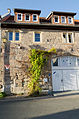
City fortifications
Remains of the 17th-18th centuries are preserved. The fortress belt laid out in the 19th century:, Fills of the former four corner bastions, in the southeast:
- the lining wall of a former ravelin, at the eastern exit of the city with cellars, casemates and corridors ( location )
- the pillar of the outer north gate, 2nd half of the 18th century, in the area of the old brickworks ( location )
- Fills of the southeast corner bastion with lining wall and vaults ( location )
- Fills of the northeast corner bastion ( location )
- Ditch and embankment of the northwest corner bastion ( location )
- Digging and embankment of the southwest corner bastion ( location )
File number: D-6-73-141-7.

Lining wall of a former ravelin

Lining wall of a former ravelin


Closed rows of farms
In the old town of Bad Königshofen im Grabfeld there are three closed streets of farms.
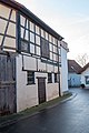
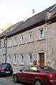
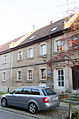
Elisabethastraße and Brauhausstraße
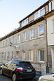
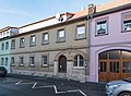
Located on the southwest edge of the old town ( location ). Uniform, closed row of farmsteads with single and double residential houses on Elisabethstrasse and farm buildings on Brauhausstrasse, the residential buildings varied by slight projections and recesses, two-storey eaves side houses, stone buildings with arched windows, auxiliary buildings with massive ground floor and upper floor in half-timbered, after fire in 1845. No. 1–5 are now part of the Elisabetha Hospital (cf. Rathausstrasse 10). Enclosure: Rathausstraße 10, Elisabethastraße 1, 3, 5, 7, 9, 11, 13, 15, 17, 19, 21, 23, 25, 27. File number: D-6-73-141-12.
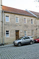
Elisabethastraße 1
Elisabethastraße 3

Elisabethastraße 5

Elisabethastraße 7
Elisabethastraße 9

Elisabethastraße 11
Elisabethastraße 13

Elisabethastraße 15

Elisabethastraße 17
Elisabethastraße 19

Elisabethastraße 21

Elisabethastrasse 23

Elisabethastraße 25

Elisabethastraße 27


Elisabethastraße 7 barn
Elisabethastraße 9 barn

Elisabethastraße 13 barn

Elisabethastraße 19 barn

Elisabethastraße 21 barn

Elisabethastraße 25 barn
Elisabethastraße 27 barn


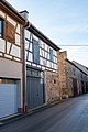
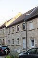
Kellereistraße and Wallstraße
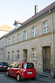
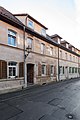
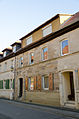
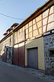
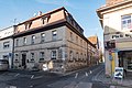
Located on the north-west edge of the city ( location ). Uniform, closed row of large farmsteads, two-storey eaves-standing residential buildings, mostly with a gable roof (No. 19 hipped roof, No. 21 half-hipped roof, No. 31 with a mansard roof) and a front made of sandstone blocks (partly plastered), with pilaster strips, cornices and some arched gate entrances Wallstraße two-storey rear building, gable roof buildings partly in quarry stone, partly in half-timbered, rebuilt after fire in 1825. Enclosure: Wallstraße 2, Kellereistraße 3, 5, 7, 9, 11, 13, 15, 17, 19, 21, 23, 25, 27, 31. File number: D-6-73-141-18.

Kellereistraße 3
Kellereistraße 5

Kellereistraße 7

Kellereistraße 9
Kellereistraße 11
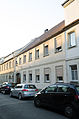
Kellereistraße 13

Kellereistraße 15
Kellereistraße 17

Kellereistraße 19

Kellereistraße 21

Kellereistraße 27
Kellereistraße 31


Kellereistraße 5, barn

Kellereistraße 7, barn

Kellereistraße 9, barn

Kellereistraße 11, barn

Kellereistraße 13, barn

Kellereistraße 19, barn
Kellereistraße 21, barn

Kellereistraße 23, barn

Kellereistraße 31, barn


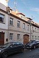
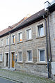
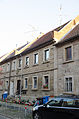
Schottstrasse and Zeughausstrasse
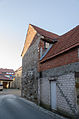
Located on the southeast edge of the old town ( location ). Uniform, closed row of farmsteads with back buildings to Zeughausstraße, two-storey eaves-standing houses in ashlar with saddle roof, two-storey back buildings z. T. in stone, Eckhof No. 18 hipped roof buildings with courtyard wall in stone, z. Partly with brick upper floor, after 1849. Enclosure : Schottstraße 4, 6, 8, 10, 12, 14, 16, 18, Zeughausstraße 11, 13. File number: D-6-73-141-70.
Zeughausstrasse 11

Zeughausstrasse 13
Schottstrasse 4

Schottstrasse 6

Schottstrasse 8
Schottstrasse 10
Schottstrasse 12
Schottstrasse 14
Schottstrasse 16
Schottstrasse 18


Schottstrasse 4, barn

Schottstrasse 10, barn

Schottstrasse 12, barn

Schottstrasse 18, barn


Architectural monuments according to districts
Bad Königshofen in Grabfeld
| location | object | description | File no. | image |
|---|---|---|---|---|
| Adam-Pfeuffer-Straße 76, corner of Raiffeisen / Adam-Pfeuffer-Straße ( location ) |
Wayside shrine | Curved base with pillar, top with reliefs of St. Anthony and Elisabeth, sandstone, 1931 | D-6-73-141-8 | |
| Am Kirchleinsweg, Kirchleinsweg ( location ) |
Wayside shrine | With reliefs of the crucifixion group and the Immaculate, sandstone, baroque, 17th century | D-6-73-141-26 | |
| Am Kirchleinsweg, Kirchleinsweg, Mittelrainweg ( location ) |
Wayside shrine | With reliefs of the mercy seat between Saint John the Baptist and Saint Paul, as well as Mary, sandstone, early baroque, 17th century | D-6-73-141-27 | |
| Near Bahnhofstrasse, in the grate plant ( location ) |
War memorial | For the fallen of the two world wars, with a reclining lion sculpture, erected around 1920, expanded after 1945 | D-6-73-141-80 |
 more pictures |
| Near Bahnhofstrasse ( location ) |
Memorial stone for Johann Wilhelm Rost | Natural stone with slate inscription plaque, probably 1920s; in the grate plant | D-6-73-141-81 |
 more pictures |
| Bamberger Straße 14 ( location ) |
Holy House | Round arch canopy with relief of the Trinity, sandstone, second half of the 19th century | D-6-73-141-9 | |
| Bamberger Straße 18, 20 ( location ) |
Wayside shrine | Rich rocaille forms on a curved base, with reliefs of the crucifixion group, Peter and Paul, and donor inscription on the reverse, sandstone, 1769 | D-6-73-141-10 | |
| Brachberg ( location ) |
Cross tug | Sculpture on a column, sandstone, late baroque, inscribed "1745" | D-6-73-141-78 | |
| Northwest of the village, towards Brachberg ( location ) |
So-called Trinity shrine | Column shrine, top with relief of the Trinity, on the reverse Christ, sandstone, inscribed "1941" | D-6-73-141-79 | |
| Elisabethastraße 1, Rathausstraße 10 ( location ) |
Elisabetha Hospital | Wide-spread three-storey stone building with hipped roof in corner position, 1851–53; today part of Elisabethastraße 1-5 (see there) | D-6-73-141-66 |
 more pictures |
| Elisabethastraße 29 ( location ) |
Former arsenal | Broad, two-storey hipped roof building in quarry stone, roof structure 1594 (d), rebuilt after 1798 | D-6-73-141-13 |
 more pictures |
| Festungsstraße 9 ( location ) |
So-called white cross | Sandstone crucifix on a curved base, late baroque, around 1750 | D-6-73-141-14 | |
| Near Großeibstädter Straße ( location ) |
graveyard | With a wall and monumental tombs from the 19th century | D-6-73-141-16 |
 more pictures |
| Near Großeibstädter Straße ( location ) |
Cemetery cross | Sandstone, 1744 | D-6-73-141-16 |
 more pictures |
| Near Großeibstädter Straße ( location ) |
War memorial chapel | Natural stone building with Christ the Redeemer, around 1950 | D-6-73-141-16 |
 more pictures |
| Near Großeibstädter Straße ( location ) |
Way of the Cross | Sandstone with stucco reliefs, around 1950 | D-6-73-141-16 |
 more pictures |
| Hindenburgstrasse 1 ( location ) |
Residential and commercial building | Narrow two-story plastered half-timbered house with a crooked hip roof, 18th century with an older core | D-6-73-141-213 |
 more pictures |
| Hindenburgstrasse 3 ( location ) |
Residential and commercial building | Two-storey gable-independent building with half hipped, grooved sandstone cuboid ground floor, plastered timber-framed upper storey, end of the 18th century | D-6-73-141-212 |
 more pictures |
| Hindenburgstraße 19, at the rear of the building ( location ) |
Inscription plaque | In the form of an aedicula with the coat of arms of Maria Bildhausen's abbot Valentin Reinhard, sandstone, 1573 | D-6-73-141-1 | |
| Hindenburgstrasse 39 ( location ) |
Former post office | Two-storey solid building with a half-hipped roof, plastered with corner blocks, around 1925 | D-6-73-141-211 |
 more pictures |
| Juliusstraße 2 ( location ) |
Craftsman House | Two-storey mansard roof building with eaves, half-timbered upper storey plastered, partly slated, 1755; The home and workshop of the sculptor Johann Joseph Keßler | D-6-73-141-17 |
 more pictures |
| Juliusstraße 4 ( location ) |
Agricultural property | Two-story house with hipped roof, second half of the 17th century | D-6-73-141-243 |
 more pictures |
| Juliusstraße 4 ( location ) |
Agricultural property | Associated barn, half-timbered, early 19th century | D-6-73-141-243 |
 more pictures |
| Kellereistraße ( location ) |
So-called Schlichtigsbrunnen | Polygonal fountain basin, sandstone, 18th century, moved here in 1781, fountain column renewed | D-6-73-141-277 |
 more pictures |
| Kellereistraße 43 ( location ) |
Residential and commercial building | Two-storey eaves gable roof building with plastered half-timbered upper storey, drilled frame profiles, 18th century | D-6-73-141-19 |
 more pictures |
| Kellereistraße 53 ( location ) |
Former official cellar | Two-storey eaves half-hipped roof building, plastered solid structure, rear courtyard wing made of quarry stone, in the core 1607 (dating on the coat of arms stone with stonemason's mark), changed in 1766 | D-6-73-141-21 |
 more pictures |
| Kellereistraße 53 ( location ) |
Courtyard wall with gate | Quarry stone, 18th century | D-6-73-141-21 |
 more pictures |
| Kellereistraße 55, 57, Wallstraße 50, Burgstraße 1 ( location ) |
Former barracks | Three- wing system with a mansard roof, planning Balthasar Neumann 1751, execution Johann Michael Fischer 1767–71 | D-6-73-141-22 |
 more pictures |
| Burgstrasse 1 ( location ) |
Former barracks, ground floor outbuilding | With hipped roof, around 1800 | D-6-73-141-22 | |
| Kellereistraße 58, Rentamtstraße 9 ( location ) |
Former Schütthaus | Three-storey, gable-independent corner building with saddle roof, plastered solid structure, rich late Renaissance portal marked "1625" | D-6-73-141-23 |
 more pictures |
| Kellereistraße 59 ( location ) |
Former Fronfests | Single-storey eaves half-hipped roof building, massive, plastered, 1808 | D-6-73-141-24 |
 more pictures |
| Kellereistraße 59 ( location ) |
Pillar portals | On both sides | D-6-73-141-24 |
 more pictures |
| Kellereistraße 61 ( location ) |
Former rent office | Two-storey, three-winged building with the main wing in stone, saddle roof with stepped gables, and lower courtyard wings in stone, historicistic, 1856; in place of the former Würzburg official palace | D-6-73-141-25 |
 more pictures |
| Kirchleinsweg ( location ) |
Statue of St. John Nepomuk | On a base with inscription, sandstone, baroque, inscribed "1725" | D-6-73-141-28 | |
| Near Kirchleinsweg ( location ) |
Wayside shrine | Top with relief of the Coronation of Mary, back of Mary, side saints and pendants, sandstone, 17th century | D-6-73-141-29 | |
| Kirchplatz 1 ( location ) |
Catholic parish church of the Assumption | Three-aisled late Gothic staggered hall with gable roof and pent roofs, southeast tower with onion dome and lantern, decorative portals in the north, west and south, 1442-1502, sacristy extension on the north side of the choir in 1486, gallery installation around 1513, octagonal tower structure 1603, renovations 1764, neo-Gothic 1865–70 by Karl Trott Ölberg 1885, figures in the south porch not until 1902), 1968 (removal of the neo-Gothic interior) and 1992/93; with equipment | D-6-73-141-30 |
 more pictures |
| Kirchplatz 3 ( location ) |
Rectory | Two-storey, massive saddle roof building with volute gables and a dwarf house with ornamental gable, plastered with corner cuboids, seat niche portal over outside staircase, 1598-1602, house Madonna, 19th century | D-6-73-141-31 |
 more pictures |
| Church square 5; Kirchplatz 7 ( location ) |
Former school | Two-storey plastered eaves side building, solid construction with saddle roof, around 1600 and 1822–23 | D-6-73-141-32 |
 more pictures |
| Church square 9; Kirchplatz 11 ( location ) |
Former Juliusspital | Two-storey solid building with a gable roof, 1584–85, three portals with coats of arms and inscription stones marked “1584” and “1616”; four gate pillars around 1800 | D-6-73-141-33 |
 more pictures |
| Monastery garden, in the spa gardens ( location ) |
Figure of St. John Nepomuk | Sandstone, 18th century | D-6-73-141-62 |
 more pictures |
| Klosterstrasse 2 ( location ) |
Residential building | Two-story plastered corner house with hipped roof, massive ground floor, half-timbered upper floor, 18th century | D-6-73-141-34 |
 more pictures |
| Klosterstrasse 8, 10, Posthalterstrasse 2 ( location ) |
Duplex | Two-storey sandstone cuboid building with hipped roof, around 1870 | D-6-73-141-35 |
 more pictures |
| Klosterstrasse 8, 10, Posthalterstrasse 2, Schottstrasse ( location ) |
barn | Belonging | D-6-73-141-35 |
 more pictures |
| Klosterstrasse 12, Klosterstrasse 14 ( location ) |
Duplex | Two-storey hipped roof building, plastered solid structure, around 1865 | D-6-73-141-36 |
 more pictures |
| Klosterstrasse 12, Klosterstrasse 14, Schottstrasse ( location ) |
barn | Belonging | D-6-73-141-36 |
 more pictures |
| Märklach; below the rag hill 10 m from the district boundary to Alsleben ( location ) |
Stone cross | So-called atonement cross in the Merklach, sandstone, early modern times | D-6-73-141-83 | |
| Marketplace ( location ) |
Michaelsbrunnen | Oval sandstone basin with a wrought-iron canopy, 1697–98 | D-6-73-141-50 |
 more pictures |
| Marketplace ( location ) |
Luitpold fountain | With a vase-like fountain bowl, a bulged fountain stick with lion heads, above a base with putti bearing a coat of arms and a baluster column with a figure of the reaper, limestone and bronze, by Balthasar Schmitt (1858-1942), 1911 | D-6-73-141-49 |
 more pictures |
| Marketplace ( location ) |
Obelisk fountain | Polygonal basin, well stock with obelisk, sandstone, 1806 | D-6-73-141-51 |
 more pictures |
| Marketplace ( location ) |
Cornstone | Grain standard measure, goblet-like basic shape with four recesses, sandstone, 1525 | D-6-73-141-52 |
 more pictures |
| Marketplace 2 ( location ) |
town hall | Free-standing three-storey hipped mansard roof building with corner bay window crowned by a lantern hood and older two-storey south wing, plastered solid construction with natural stone structures, vaulted ground floor, Renaissance, in the core 15th century, south wing 1563/64, main building 1573–75, partially redesigned in the 18th century; with equipment | D-6-73-141-38 |
 more pictures |
| Marketplace 4 ( location ) |
House in a corner | Elongated three-storey building with hipped mansard roof, solid ground floor, upper storeys in half-timbered houses, 17th / 18th centuries century | D-6-73-141-39 |
 more pictures |
| Marketplace 7 ( location ) |
Inn | Three-storey corner house with hipped roof, solid ground floor, upper floors in half-timbered, 18th / 19th century. century | D-6-73-141-40 |
 more pictures |
| Marketplace 7 ( location ) |
Public house sign | From Gasthof Neuses near Hofheim in Lower Franconia, inscribed "1796" | D-6-73-141-40 |
 more pictures |
| Marketplace 10 ( location ) |
Residential and commercial building | Two-storey eaves building with mansard roof, plastered half-timbering, 18th / 19th centuries century | D-6-73-141-41 |
 more pictures |
| Marktplatz 11 ( location ) |
Residential and commercial building | Two-storey eaves solid building with mansard roof, sandstone cuboid, probably from the end of the 18th century / 19th. century | D-6-73-141-42 |
 more pictures |
| Marktplatz 15 ( location ) |
Residential and commercial building | Saddle roof construction with eaves, plastered framework, core 1437 (d), later changed | D-6-73-141-43 |
 more pictures |
| Marktplatz 20 ( location ) |
Corner house | Two-storey above a high cellar, plastered building with hipped roof, solid, around 1800 | D-6-73-141-44 |
 more pictures |
| Marktplatz 21 ( location ) |
Residential and commercial building | Three-storey eaves side house with saddle roof, solid construction with drilled frames and grooved pilaster strips, 18th century | D-6-73-141-45 |
 more pictures |
| Marktplatz 25 ( location ) |
Former council tavern | Elongated two-storey corner building with hipped roof, solid, core 16./17. Century, later changed | D-6-73-141-46 |
 more pictures |
| Marktplatz 31 ( location ) |
Residential and commercial building | Three-storey mansard roof building with eaves, plastered solid construction with side pilasters, 18th century | D-6-73-141-47 | |
| Martin-Reinhard-Straße 8 ( location ) |
Residential and commercial building | Two-storey eaves saddle roof construction in ashlar, around 1870 | D-6-73-141-53 |
 more pictures |
| Martin-Reinhard-Straße 8 ( location ) |
barn | Backwards, at the same time | D-6-73-141-53 | |
| Martin-Reinhard-Straße 9 ( location ) |
Former Wechterwinkler Schranne | Today Grabfeld Museum, three-storey, gable-independent, massive saddle roof structure with divisions in red sandstone, around 1600, inscribed "1693" | D-6-73-141-54 |
 more pictures |
| Kellereistraße 42 ( location ) |
Former Wechterwinkler Schranne | Two-story rear building on the eaves, saddle roof with stepped gables, around 1600 | D-6-73-141-54 |
 more pictures |
| Martin-Reinhard-Straße 15 ( location ) |
Former Schultheißenhaus | Two-storey mansard roof building with eaves, with corner pilasters, arched drilled windows and portal with protective Madonna, inscribed "1728" | D-6-73-141-55 |
 more pictures |
| Martin-Reinhard-Straße 19, Bezirksamtstraße 3 ( location ) |
Residential building | Two-storey with a half-hipped roof, plastered half-timbering, mid-18th century with an older core | D-6-73-141-2 |
 more pictures |
| Martin-Reinhard-Straße 19, Bezirksamtstraße 3 ( location ) |
Rear building | Half-timbered structure, with high arbors, 18./19. century | D-6-73-141-2 | |
| Martin-Reinhard-Straße 27 ( location ) |
Mohr pharmacy | Two-storey mansard roof building on the eaves, ashlar with frame and decorative shapes, elaborate decorative portal, late baroque, 18th century | D-6-73-141-57 |
 more pictures |
| Martin-Reinhard-Strasse 28; Near Martin-Reinhard-Straße ( location ) |
Catholic Capuchin Church of St. John Evangelista | Hall building with retracted choir, nave with gable roof, choir with hipped roof and turret with pointed helmet, 1663–65 with late Gothic spoilage of the St. Johannis monastery church near Sulzfeld, neo-Romanesque entrance porch in stone, around 1900 | D-6-73-141-58 |
 more pictures |
| Martin-Reinhard-Strasse 28; Near Martin-Reinhard-Straße ( location ) |
Monastery wall | Gate with the coat of arms of Prince-Bishop Johann Gottfried von Guttenberg, inscribed "1692" | D-6-73-141-58 |
 more pictures |
| Martin-Reinhard-Strasse 29 ( location ) |
Residential and commercial building | Two-storey mansard roof house with eaves, solid, 18th century, ground floor gutted at the end of the 20th century | D-6-73-141-59 |
 more pictures |
| Martin-Reinhard-Strasse 33 ( location ) |
Residential building | Two-storey corner building with hipped roof, facade with grooved corner pilasters and classicist plait decorations, carved front door, end of the 18th century, half-timbered view of Rentamtstrasse | D-6-73-141-60 |
 more pictures |
| Martin-Reinhard-Strasse 33 ( location ) |
Half-timbered wing construction | 18th century | D-6-73-141-60 | |
| Rathausstrasse 5 ( location ) |
Residential and guest house | Two-storey mansard roof house with eaves, plastered half-timbering, 18th century | D-6-73-141-64 |
 more pictures |
| Rathausstrasse 11 ( location ) |
Residential building | Three-storey eaves side building with gable roof, plastered half-timbering, 17th century, ground floor changed in the 19th century | D-6-73-141-67 |
 more pictures |
| Rentamtstrasse 2 ( location ) |
Residential buildings | Two-storey corner building with a gable roof, massive ground floor with exposed corner cuboid and twin windows, probably early 16th century upper floor with ornamental framework around 1600 | D-6-73-141-68 |
 more pictures |
| Rentamtstrasse 2 ( location ) |
Cultivation | 18./19. century | D-6-73-141-68 |
 more pictures |
| Schnellerstraße 1 ( location ) |
Maria Immaculate | On a rococo console, sandstone, second half of the 18th century | D-6-73-141-69 |
 more pictures |
| Schottstrasse 20 ( location ) |
Agricultural farm in corner location | Two-story house, hipped roof, main facade solid with drilled frames, side front with slate cladding, inscribed "1740" | D-6-73-141-71 |
 more pictures |
| Schottstrasse 20 ( location ) |
House figure | baroque Immaculata, sandstone, 18th century | D-6-73-141-71 |
 more pictures |
| Schottstrasse 20 ( location ) |
Courtyard wall and outbuildings | Half-timbered, on the rear building with a gable roof, relief stone with crucifixion, sandstone, heavily weathered | D-6-73-141-71 |
 more pictures |
| Schottstrasse 22 ( location ) |
Residential building | Two-storey eaves side building with gable roof, massive, around 1870, the core of the 17th century | D-6-73-141-72 |
 more pictures |
| Senefelderstrasse 5 ( location ) |
House in a corner | Two-story hipped roof house, massive plastered building with exposed corner blocks, around 1870 | D-6-73-141-75 |
 more pictures |
| Spitalfeld ( location ) |
Column shrine | With Pietà, sandstone, 18th century | D-6-73-141-73 | |
| Hospital wood; in Spitalholz on the road to Herbstadt on the boundary ( location ) |
Stone cross | So-called atonement cross, sandstone, late medieval | D-6-73-141-206 | |
| Sudetenstrasse 6 ( location ) |
Evangelical Lutheran Church | Sandstone block construction, hall construction with a gable roof, west tower with an octagonal dormer-studded pointed helmet, western entrance porch, historicist in the forms of the 13th century, 1894–98 | D-6-73-141-74 | |
| Near Thüringer Straße, on Wallgraben ( location ) |
War memorial for 1870/71 | Stepped plinth with a high round pedestal with a statue of the Patrona Bavariae, red sandstone and limestone, by Josef Metzger (1846-1925), inscribed "1887" | D-6-73-141-77 |
 more pictures |
| Near Wallstraße ( location ) |
Former mare | Three-aisled vaulted stable, gable-free house installation with flat sloping gable roof and towed eaves-side canopy on bends, around 1860/70 | D-6-73-141-191 | |
| Near Wallstraße ( location ) |
Former stud farm, opposite a smaller gable-independent stable building | With a gently sloping gable roof, ground floor in stone, half-timbered knee floor, second half of the 19th century | D-6-73-141-191 | |
| White cross; in a field on the road to Althausen ( location ) |
Floor cross | Sandstone crucifix on a curved base, inscribed "1746" | D-6-73-141-82 |
Althausen
| location | object | description | File no. | image |
|---|---|---|---|---|
| On the high rain; Flurweg to Merkershausen ( location ) |
Wayside shrine | Sandstone with metal relief, Pietà, inscribed "1939" | D-6-73-141-96 | |
| On the hat; at the exit to Königshofen ( location ) |
Holy House | Sandstone, 20th century | D-6-73-141-91 | |
| On the hat; at the exit to Bad Königshofen ( location ) |
Sandstone crucifix | marked "1950" | D-6-73-141-92 | |
| Auber way; Flurweg to Aub ( location ) |
Floor cross | Sandstone, inscribed "1890" | D-6-73-141-98 | |
| Baumgarten Hill; southeast above the place ( location ) |
Mary's Grotto | Tuff stone grotto with stucco figure, steps in front, early 20th century | D-6-73-141-230 | |
| Dippach; on the "Kurzen Steige" to the Sambach ( location ) |
Pietà | Group of figures on a high base stone with inscription, sandstone, late baroque, inscribed "1755" | D-6-73-141-6 | |
| Sinkhole; at the Kronenmarter ( location ) |
Wayside shrine | Reliefs: Mary and crucifixion group, sandstone, 1740 | D-6-73-141-93 | |
| Goose tree; in front of the Sambachhof ( location ) |
Sandstone crucifix | baroque, first half of the 18th century | D-6-73-141-100 | |
| Behind the village; on the road to Aub ( location ) |
Pietà | Sculpture on a high base, sandstone, inscribed "1885" | D-6-73-141-3 | |
| Kirchstrasse 7 ( location ) |
Former rectory | Two-storey hipped roof building with a plastered half-timbered upper storey, second half of the 18th century | D-6-73-141-233 | |
| Kirchstrasse 9; In Althausen ( location ) |
Catholic parish church of St. Maria Magdalena | Choir tower church, solid construction, tower with pointed helmet in the core late Gothic, 14th century, post-Gothic increased after 1611, nave with saddle roof 1693-1708, changed “1785” (marked on the north portal), western extension in the second half of the 19th century; with equipment | D-6-73-141-84 | |
| Kirchstrasse 9; In Althausen ( location ) |
Two rows of Kirchgaden | Solid and half-timbered with gable or pent roofs, 17th – 19th centuries century | D-6-73-141-84 | |
| Kirchstrasse 10 ( location ) |
Residential building | Two-story hipped roof building with half-timbered upper storey, 18th century, slate and house Madonna inscribed "1883" | D-6-73-141-234 | |
| Kirchstrasse 14; In Althausen ( location ) |
Rectory | Rectory, two-storey plastered hipped roof building over a high cellar, Wappenstein, 1811 | D-6-73-141-88 | |
| Kirchstrasse 14; In Althausen ( location ) |
Rectory | Court wall and gate with gate and pillars studded with vases, sandstone | D-6-73-141-88 | |
| Kirchstrasse 14; In Althausen ( location ) |
Rectory | Outbuildings on an angular floor plan, hipped and half-hipped roof, solid and half-timbered | D-6-73-141-88 | |
| Kirchstrasse 14; In Althausen ( location ) |
Rectory | Garden with a cross-shaped path system | D-6-73-141-88 | |
| Kurzer Steig, "Wonnegrube" forest department ( location ) |
Atonement Cross | Sandstone | D-6-73-141-99 | |
| Near Althäuser Straße; at the exit to Bad Königshofen ( location ) |
Pietà | Sandstone with old setting, baroque, from 1786 | D-6-73-141-4 | |
| Red pond; Corridor department "Spitalweg" ( location ) |
Cross tug | Sandstone, inscribed "1747" | D-6-73-141-94 |
 more pictures |
| Sambachstrasse 10 ( location ) |
Inn | Two-storey sandstone cuboid building with a gable roof and lower side extension, high base, open staircase, around 1880/90 | D-6-73-141-232 | |
| Sambachstrasse 12 ( location ) |
Former community office | Eaves two-storey saddle roof building with gate entrance, massive ground floor, half-timbered upper floor, inscribed "1774" | D-6-73-141-192 | |
| Sambachstrasse 49; Kleines Steinig ( location ) |
Cemetery cross | Sandstone, second half of the 19th century | D-6-73-141-85 | |
| Sambachstrasse 49; Kleines Steinig ( location ) |
War memorial chapel | Polygonal closed saddle roof building with an open column portico and a staircase in front, memorial plaques for those who fell in both world wars, Pietà, around 1920 | D-6-73-141-85 | |
| Lock piece ( location ) |
Column shrine | Essay with reliefs of the fourteen saints and the crucifixion group, sandstone, 1733 | D-6-73-141-97 | |
| Spitalweg; north of the village on the return path ( location ) |
Column shrine | Sandstone, top with metal relief of the Pietà, inscribed "1737", renovated in 1952 | D-6-73-141-193 | |
| Spitalweg; in front of the sports field on the road to Bad Königshofen ( location ) |
Sandstone crucifix | marked 1887 | D-6-73-141-95 | |
| Tenth street; Zehntstrasse 10 ( location ) |
Processional altar | With trinity relief, sandstone, neo-Gothic, around 1850 | D-6-73-141-87 | |
| To the grotto; in front of the cemetery ( location ) |
Column shrine | Top with reliefs of Mary and crucifix, sandstone, mid-19th century | D-6-73-141-89 | |
| To the grotto; Dirt road on the eastern outskirts ( location ) |
Holy House | Sandstone, 20th century | D-6-73-141-90 |
Aub
| location | object | description | File no. | image |
|---|---|---|---|---|
| Alte Schmiede 1 ( location ) |
Former village smithy | Single-storey corner building in half-timbered construction with a gable roof, 1764 | D-6-73-141-103 | |
| Bartelsacker; on embankment on the road to Bundorf ( location ) |
Plague cross | Sandstone, 17th century | D-6-73-141-108 | |
| Haßbergstrasse 15 ( location ) |
Catholic Kuratiekirche St. Peter and Paul | North-facing hall church with gable roof and retracted choir, neo-Romanesque, 1863–64, attached to the former choir tower to the west, tower substructure end of the 15th century, upper floor with onion dome and lantern, 1603; with equipment | D-6-73-141-101 | |
| Haßbergstrasse 15 ( location ) |
Churchyard wall | In the core 15./16. century | D-6-73-141-101 | |
| Haßbergstrasse 19 ( location ) |
farm | Two-storey, gable-independent residential building with a solid ground floor, half-timbered upper storey and gable roof, labeled "1862", courtyard gate with gate labeled "1802" | D-6-73-141-218 | |
| Haßbergstrasse 27 ( location ) |
Cemetery cross | Sandstone crucifix, late 19th century | D-6-73-141-102 | |
| Small village ( location ) |
Column shrine | Rich essay with reliefs of the crucifixion group between Peter and Paul, back with Saint Barbara, as crowning St. George, sandstone, inscribed "1736" | D-6-73-141-104 |

|
| Small village 8 ( location ) |
Rectory | Two-story massive hipped roof building, neo-baroque, 1908 | D-6-73-141-194 | |
| Near Haßbergstraße ( location ) |
Column shrine | Essay with relief of the founding family under the crucifixion group, to the side Peter and Paul, reverse Vesper picture, sandstone, baroque, 1677 | D-6-73-141-105 | |
| Near state road 2275; Exit to Bad Königshofen ( location ) |
crucifix | On a curved base, at the base of the cross a tabernacle, sandstone, late baroque, inscribed "1767" | D-6-73-141-107 | |
| Oberdorf ( location ) |
Niche shrine | Barrel-vaulted niche with relief of Mary, sandstone, "1760". | D-6-73-141-106 |
Eyershausen
| location | object | description | File no. | image |
|---|---|---|---|---|
| Am Lindenplan 1 ( location ) |
Residential stable house | Single-storey half-timbered building with a half-hipped roof in a corner, around 1800 | D-6-73-141-116 |
 more pictures |
| Am Lindenplan 5 ( location ) |
Gate | With curtain arch, 17./18. century | D-6-73-141-235 | |
| Am Lindenplan 16 ( location ) |
Community brewery | One-and-a-half-storey sandstone block building with a gable roof and stepped gables, historicist, inscribed "1870" | D-6-73-141-197 |
 more pictures |
| Hauptstrasse 1 ( location ) |
Crucifixion group | Sandstone, on a wide base, cross base with Christian symbols, late baroque, 1743 | D-6-73-141-123 | |
| Hauptstrasse 17 ( location ) |
Farmhouse | Three-storey, gable-independent half-hipped roof building, upper storeys half-timbered, around 1800 | D-6-73-141-110 |
 more pictures |
| Hauptstrasse 18 ( location ) |
House figure | Pietà, mounted sculpture, baroque, 17th / 18th centuries century | D-6-73-141-115 |
 more pictures |
| Hauptstrasse 20 ( location ) |
Community inn | On a corner plot, eaves-standing two-storey sandstone block construction with a gable roof, 1874 | D-6-73-141-196 |
 more pictures |
| Hauptstrasse 20 ( location ) |
Half-timbered barn | With a gable roof, around 1875 | D-6-73-141-196 |
 more pictures |
| Hauptstrasse 21 ( location ) |
House figure | Saint George, mounted sandstone sculpture, 18th century | D-6-73-141-111 | |
| Eyershäuser Strasse ( location ) |
Milestone | Sandstone, after 1872 | D-6-73-141-237 |
 more pictures |
| Herbstadter Weg, at the north-western exit towards Herbstadt ( location ) |
Holy House | Curved base with arched picture niche with relief of the crucifixion group, sandstone, baroque, mid-18th century | D-6-73-141-119 | |
| Hutwiese, on a dirt road southwest of the village ( location ) |
Holy House | Arched picture niche with relief, sandstone, baroque, probably 1751, severe weather damage | D-6-73-141-120 | |
| Kirchenweg ( location ) |
War memorial 1914-18 | Sandstone sculpture of the risen Christ on a block-shaped base, around 1920/25 | D-6-73-141-238 |
 more pictures |
| Kriegergasse, Hauptstrasse ( location ) |
Holy House | Curved base with arched pictorial niche and relief of the Coronation of Mary, crowned by a statue of St. Wendelin, sandstone, 18th century | D-6-73-141-114 |
 more pictures |
| Kirchenweg 4 ( location ) |
farm | Two-storey, gable-independent residential building on a high sandstone base with a two-flight staircase in front of the eaves, brick masonry on the ground floor, upper floor and gable half-timbered, gable roof, historicist, around 1900 and 1934 | D-6-73-141-204 | |
| Kirchenweg 4 ( location ) |
Farm, elongated outbuilding | Ground floor made of sandstone blocks, upper floor half-timbered with arcade, second half of the 19th century | D-6-73-141-204 |
 more pictures |
| Kirchenweg 6 ( location ) |
Former parish and school house | Today a kindergarten, two-storey building hipped towards the street, massive ground floor over sandstone plinth, plastered half-timbered upper floor, mid-18th century, with recent changes and an extension | D-6-73-141-195 |
 more pictures |
| Kirchenweg 8 ( location ) |
Catholic parish church of St. Wendelin | Hall building with saddle roof and polygonal choir, west facade with facade tower, sandstone cuboid, onion dome, late baroque, by Johann Müller from Arnstein, 1752–54; with equipment | D-6-73-141-109 |
 more pictures |
| Kirchenweg 8 ( location ) |
Cemetery walling | Sandstone cuboid with cover plates, 17th / 18th centuries century | D-6-73-141-109 |
 more pictures |
| Kirchenweg 8 ( location ) |
Cemetery cross | Sandstone, from 1861, between two priest grave stones | D-6-73-141-109 |
 more pictures |
| Kirchenweg 8 ( location ) |
Two priest gravestones | Relief, red sandstone, second half of the 19th century | D-6-73-141-109 |
 more pictures |
| Mittelweg, on the road to Trappstadt ( location ) |
Column shrine | With Kreuzschlepper, sandstone, baroque style, 1907 | D-6-73-141-122 | |
| Mittelweg ( location ) |
Stone cross | Latin form with short arms and incised drawing on the front, sandstone, inscribed "1.24" (probably 1624) | D-6-73-141-306 | |
| Seeweg, at the exit to Trappstadt ( location ) |
Wayside shrine | With column, top with relief of the crucifixion, on the sides Barbara and Margareta, on the reverse a scene of the Mount of Olives, sandstone, late baroque, inscribed "1761" | D-6-73-141-121 |
 more pictures |
| Suburb ( location ) |
Holy House | Simple base with arched picture niche with relief of the erection of the cross, sandstone, baroque, 18th century | D-6-73-141-113 |
 more pictures |
Gabolshausen
| location | object | description | File no. | image |
|---|---|---|---|---|
| At the Hague; On the Mühlweg; Torstrasse ( location ) |
Gabolshausen wayside shrine | In rich rococo forms, top with relief of the crucifixion group, inscribed "1767" | D-6-73-141-128 |

|
| Grass path; at the exit to Königshofen ( location ) |
Column shrine | With bulbous base, top with reliefs of the Trinity and the Adoration of the Magi, saints on the side, sandstone, 18th century | D-6-73-141-129 |

|
| Hague; at the exit to Untereßfeld in front of the sports field ( location ) |
Sandstone crucifix | Pedestal with mourning Mary, 18th century | D-6-73-141-131 |

|
| Mühlhügelstraße 18 ( location ) |
Maria Immaculate | On a pedestal, sandstone, 19th century | D-6-73-141-127 | |
| Near Torgasse; at the churchyard wall ( location ) |
Holy House | Curved base with arched and crowned picture niche with crucifix, Christian symbols on the inside, sandstone, inscribed "1779" | D-6-73-141-126 |

|
| Oberschaar ( location ) |
Wayside shrine | Reliefs: Mercy Seat, Immaculata, sandstone, inscribed "1946", base around 1900 | D-6-73-141-225 | |
| Oberschaar ( location ) |
Wayside shrine | Base with pillar, top with relief of the Pietà, sandstone, inscribed "1716" | D-6-73-141-130 | |
| Torstrasse 1 ( location ) |
Gatehouse | Single-storey half-timbered building with a gable roof and lateral road passage, 16./17. Century, half-timbered 18th / 19th century. Century renewed, reconstruction in 1990 | D-6-73-141-125 |

|
| Torstrasse 3; In Gabolshausen ( location ) |
Catholic branch church of St. Laurentius | Cuboid sandstone building, hall building with gable roof, side tower with octagon and mansard helmet, neo-Gothic choir, 1911; with equipment | D-6-73-141-124 |
 more pictures |
| Torstrasse 3; In Gabolshausen ( location ) |
Cemetery cross | Limestone, around 1910 | D-6-73-141-124 | |
| Torstrasse 3; In Gabolshausen ( location ) |
War memorial | Crowned sculpture Dying Soldier, limestone, signed by Schneider, around 1920; Cemetery wall with gate, 18th century | D-6-73-141-124 |

|
Göckesmühle
| location | object | description | File no. | image |
|---|---|---|---|---|
| B 279 ( location ) |
milestone | Sandstone, third quarter of the 19th century | D-6-73-141-242 |
Haumühle (Ipthausen)
| location | object | description | File no. | image |
|---|---|---|---|---|
| Haumühle 2 ( location ) |
Chopper | Four-sided courtyard, single-storey residential building with half-hipped roof, half-timbered building partly plastered, sandstone cuboid facing Mühlbach, slated gable, end of the 18th century | D-6-73-141-241 | |
| Haumühle 2 ( location ) |
Haumühle, half-timbered barn | With a gable roof, around 1800 | D-6-73-141-241 | |
| Chop mill 2; Ipthausen, Haumühle 2 ( location ) |
Haumühle, outbuilding | With half-timbered upper floor and gable roof, second half of the 19th century | D-6-73-141-241 |
Ipthausen
| location | object | description | File no. | image |
|---|---|---|---|---|
| Church 3 ( location ) |
Pilgrimage Church of the Birth of Mary | Hall building with saddle roof, retracted polygonal closed choir with turret with onion dome, west facade sandstone cuboid with figure niches, 1746–54, by Johann Michael Schmidt, facade figures by Sebastian Metz, renovation of the choir after fire by Karl Trott 1868–71; with Rococo decor by Bernhard Hellmuth and Georg Anton Urlaub u. a. | D-6-73-141-132 |
 more pictures |
| Church 5; south in front of the church ( location ) |
Stone cross | So-called plague cross, sandstone, early modern | D-6-73-141-133 | |
| Kirchleinsweg; on the Birkenallee to Königshofen ( location ) |
Wayside shrine | Pillar with top and reliefs of the Crucifixion and the Trinity, sandstone, 19th century | D-6-73-141-141 | |
| Kirchleinsweg; on the Birkenallee to Königshofen ( location ) |
Cross tug | On a pillar, sandstone, first half of the 19th century | D-6-73-141-143 | |
| Kirchleinsweg; on the Birkenallee to Königshofen ( location ) |
Man of Sorrows | Base with inscription, sandstone, 18./19. century | D-6-73-141-142 | |
| Kirchleinsweg; at the beginning of the birch avenue in front of the church ( location ) |
Wayside shrine | Column with top and reliefs of the donor family under the crucifixion group, on the back a group of figures, sandstone, 17th century | D-6-73-141-134 | |
| Near Kirchleinsweg; southeast in front of the church ( location ) |
Statue of St. John Nepomuk | Bulged base with inscription, sandstone, baroque, early 19th century | D-6-73-141-135 | |
| Linde 1 ( location ) |
Courtyard gate | With drilled, profiled frame, sandstone, inscribed "1720" | D-6-73-141-136 | |
| Linde 21 ( location ) |
Courtyard gate system | Pillar with flower reliefs, natural stone, 19th century | D-6-73-141-137 | |
| Linde 29 ( location ) |
barn | Solid with gable roof, half-timbered gable, 18th century | D-6-73-141-198 | |
| Merklach; Corner of Simmern ( location ) |
Sandstone crucifix | With a base, classicistic, end of the 18th century | D-6-73-141-140 | |
| Weißbach 3 ( location ) |
Residential building | Single-storey gable roof building, plastered half-timbering, 18th century | D-6-73-141-138 | |
| Weißbach 5 ( ) |
Residential building | Single-storey half-timbered building with gable roof, 18th century | D-6-73-141-139 | |
| Merzenweg; outside the local area at the corner of Dr.-Hans-Kentmann-Weg / Bgm.-Eschenbach-Allee ( location ) |
Sandstone crucifix | With base, last quarter of the 19th century | D-6-73-141-145 | |
| Spitalwaldstrasse 12; in the new development area of Bad Königshofen ( location ) |
Jewish Cemetery | With gravestones until 1939, laid out in 1921 | D-6-73-141-199 |
 more pictures |
| White bridge; at the pasture ( location ) |
Column shrine | Top with relief of Mary, crucifixion on the reverse, sandstone, 1938 | D-6-73-141-144 |
Merkershausen
| location | object | description | File no. | image |
|---|---|---|---|---|
| At the dugout; at the exit to Königshofen ( location ) |
Wayside shrine | Column with top and reliefs of the Coronation of Mary, on the back a crucifixion group, on the side holy bishops, baroque, 1718 | D-6-73-141-166 | |
| Bäckergasse 1 ( location ) |
Courtyard gate | With shoulder arch and gate post with rose ornamentation, natural stone, 18th century | D-6-73-141-158 | |
| Bäckergasse 2 ( location ) |
Courtyard gate | With shoulder arch, natural stone, 18th century | D-6-73-141-160 | |
| Bäckergasse 9 ( location ) |
Courtyard gate | Curtain arch, sandstone, inscribed "1713" | D-6-73-141-159 | |
| Heir; on dirt road southeast of the village ( location ) |
Holy House | Base with arched pictorial niche, sandstone, 1773, painted Saint Wendelin, new | D-6-73-141-167 | |
| Flossy; at the exit to Kleinbardorf ( location ) |
Sandstone crucifix | Pedestal with mourning Mary, sandstone, 1765 | D-6-73-141-163 |

|
| Kapellenweg ( location ) |
Wayside shrine | Pillar with top with relief of the crucifixion group, coat of arms above, sandstone, inscribed 1607; formerly on the road to Kleinbardorf | D-6-73-141-164 | |
| Kapellenweg 20; northeast of the place ( location ) |
Protective mantle chapel | So-called Swedish Chapel, war memorial chapel for 1866, sandstone cuboid construction, hall construction with saddle roof, round apse and gable turret, neo-Gothic, 1867/68 | D-6-73-141-200 | |
| Upper Alley; Obere Gasse 1 ( location ) |
Gate pillar | With plastered ashlar, stone, 18th century | D-6-73-141-156 | |
| Obere Gasse 3; Near Ringgasse ( location ) |
Rectory | Two-storey, gable-independent half-hipped roof, massive ground floor with Renaissance windows 1584, plastered upper floor 1773, sandstone Madonna around 1350 | D-6-73-141-146 |

|
| Obere Gasse 3; Near Ringgasse ( location ) |
Vicarage, courtyard gate | With gate and coat of arms stone Abbot Thomas III. from Langheim Abbey, around 1680 | D-6-73-141-146 |

|
| Obere Gasse 3; Near Ringgasse ( location ) |
Rectory | Outbuilding, partly half-timbered, partly massive, with saddle or half-hipped roof, 18th century | D-6-73-141-146 |

|
| Obere Gasse 3 ( location ) |
Wayside shrine | Top with columns and cranks in the form of an altar with a relief of the Trinity between Paul and Peter, in the excerpt the coronation of the Virgin Mary and angels, on the back niches with the Saints Andrew Katharina and Barbara, sandstone, baroque, inscribed "1727" | D-6-73-141-223 |

|
| Obere Gasse 5; Near Obere Gasse ( location ) |
Catholic parish church of St. Martin | Tower on the north side of the choir with pyramid roof, lower floor late Gothic, 14th century, post-Gothic raised by Valentin Dietz in 1601, nave, hall church with rich stone-faced west facade, gable roof, plastered eaves, recessed choir, baroque, planning by Johann Michael Neum , revision by Balthasarann 1737–43; with equipment | D-6-73-141-147 |
 more pictures |
| Obere Gasse 5; Near Obere Gasse ( location ) |
Churchyard wall | With war memorial for 1914–18, relief of Christ crowning dead soldiers, around 1920, and Mary's grotto with stucco Madonna, around 1900 | D-6-73-141-147 |

|
| Obere Gasse 5; Near Obere Gasse; in the cemetery ( location ) |
Cemetery cross | Second half of the 19th century | D-6-73-141-147 |

|
| Obere Gasse 5; Near Obere Gasse ( location ) |
Virgin Mary statue | Historicistic, sandstone, second half of the 19th century | D-6-73-141-147 |

|
| Obere Gasse 6 ( location ) |
Former school house | Hipped roof building, massive ground floor, half-timbered upper floor, early 19th century | D-6-73-141-148 |

|
| Obere Gasse 17 ( location ) |
Courtyard gate system | Ball-crowned pillars, gate with figure of Maria Immaculata, sandstone, 1747 | D-6-73-141-149 | |
| Ringgasse, in front of No. 31 ( location ) |
Wayside shrine | Immaculata between Apostle Paul and St. Ursula, crowning St. Andreas, backside scene with St. Anthony, acanthus frame, baroque, by Jakob Bindrim, inscribed "1729" | D-6-73-141-162 | |
| Rose Garden; Corner Am Erb / Althäuser Weg ( location ) |
Wayside shrine | Reliefs: baptism of Jesus between Joseph and Mary, back Joachim and Anna, crowning Dorothea, sandstone, baroque, inscribed "1738" | D-6-73-141-165 | |
| Drive path; south of the gravel pit, old road ( location ) |
Wayside shrine | With stonemason's mark, sandstone, inscribed "1603", screwed on naive paintings farmer with plow, sowing and harvesting on the side | D-6-73-141-168 | |
| Vogelgasse 9 ( location ) |
House figure | Our Lady with putti, wood, 18./19. century | D-6-73-141-150 | |
| Vogelgasse 12 ( location ) |
Gate | Curtain arch, sandstone, inscribed "1731" | D-6-73-141-152 | |
| Vogelgasse 17 ( location ) |
Residential building | Single-storey solid building with gable roof, street front marked “1733”; Courtyard gate with curtain arch, inscribed "1736" | D-6-73-141-151 |

|
| Vogelgasse 17 ( location ) |
Courtyard gate | With curtain arch, inscribed "1736" | D-6-73-141-151 |

|
| Wirtsgasse 11 ( location ) |
Gate | Curtain arch, sandstone, 17th century | D-6-73-141-155 |

|
Untereßfeld
| location | object | description | File no. | image |
|---|---|---|---|---|
| At the Herrenhof; Town center ( location ) |
Mariendenkmal | Neo-Gothic sandstone statue on a high base within a cast iron enclosure, 1885 | D-6-73-141-186 |

|
| Am Herrenhof 1 ( location ) |
Rectory | Two-storey, massive rectory with a gable roof, high cellar with outside staircase, Renaissance, 1612 | D-6-73-141-171 |

|
| Am Herrenhof 1 ( location ) |
Rectory | Farm building with natural stone substructure and half-timbered knee, crucifixion relief, 17th / 18th centuries century | D-6-73-141-171 |

|
| Am Herrenhof 1 ( location ) |
Rectory | Courtyard wall with gate, sandstone, inscribed "1710" | D-6-73-141-171 |

|
| Am Herrenhof 2 ( location ) |
farm | Gable-independent ground floor residential stable house, gable with ornamental framework, courtyard side half-timbered with arbor, rear wall in stone, 17th century | D-6-73-141-172 |

|
| Am Herrenhof 2 ( location ) |
farm | Side building, two-storey delivery house with arbor, half-timbered, 18th century | D-6-73-141-172 |

|
| Am Herrenhof 2 ( location ) |
Farm, barn | Fachwerk, 18./19. century | D-6-73-141-172 | |
| Am Herrenhof 6 ( location ) |
Courtyard wall | Natural stone, with courtyard gate, round arched, around 1600, with Jesus figure, 19th century; Inscription stone, inscribed "1695" | D-6-73-141-203 |

|
| Am Herrenhof 6 ( location ) |
Courtyard arbor | With wooden pillars, around 1700 | D-6-73-141-203 | |
| Anger, road to Alsleben ( location ) |
Wayside shrine | Reliefs crucifixion group, reverse side St. Wendelin, sandstone, inscribed "1836" | D-6-73-141-187 | |
| Pool ( location ) |
Wayside shrine | Relief of St. Wendelin, 1836 | D-6-73-141-189 | |
| Eßfelder Straße 3 ( location ) |
Farmhouse | Two-storey eaves half-timbered building with half-hip roof and hip foot as a storey separation, 18th / 19th century century | D-6-73-141-202 | |
| Eßfelder Straße 10 ( location ) |
farm | Residential stable house, single-storey gable-roof building, residential part with ornamental framework, solid stable part, around 1700 | D-6-73-141-201 | |
| Eßfelder Strasse; Eßfelder Straße 5 ( location ) |
Gate | Curtain arch, natural stone, 1742 | D-6-73-141-175 | |
| Eßfelder Straße 10 ( location ) |
farm | Pigsty, 19th century | D-6-73-141-201 | |
| Eßfelder Straße 12 ( location ) |
farm | Single-storey, gable-independent residential building with a gable roof, ornamental framework, around 1700, extended at the back in the 18th century | D-6-73-141-174 | |
| Eßfelder Straße 12 ( location ) |
farm | Multi-part outbuilding, half-timbering, gable roof, 17th / 18th centuries Century; Barn, half-timbering, gable roof hipped on one side, 18th century | D-6-73-141-174 | |
| Eßfelder Straße 12 ( location ) |
farm | Courtyard gate, natural stone, arched gate marked "1695", gate pillar around 1800 | D-6-73-141-174 | |
| Eßfelder Straße 17 ( location ) |
House figure | Baroque statue of the Virgin Mary, sandstone, 18th century | D-6-73-141-176 |

|
| Eßfelder Straße 33 ( location ) |
House figure | Saint Wendelin, early 19th century | D-6-73-141-181 | |
| Eßfelder Straße 35 ( location ) |
House figure | Pietà, baroque, 17th / 18th centuries century | D-6-73-141-182 | |
| Friedhofweg 1; Eßfelder Strasse ( location ) |
graveyard | Cemetery cross, stepped base architecture with columns and reliefs of the symbols of the evangelists, 1883 | D-6-73-141-170 | |
| Friedhofweg 1; Eßfelder Strasse ( location ) |
graveyard | Cemetery wall with goal posts | D-6-73-141-170 | |
| Friedhofweg 1; Eßfelder Strasse ( location ) |
Cemetery, on the cemetery wall fourteen stations of the cross | Natural stone with iron reliefs, first half of the 19th century | D-6-73-141-170 | |
| Friedhofweg 1; Eßfelder Strasse ( location ) |
graveyard | In the cemetery wall holy house with crucifix, from 1750 | D-6-73-141-170 | |
| on the north-western outskirts ( location ) |
Holy House | From 1753; not re-qualified | D-6-73-141-185 | |
| Mühlrangen ( location ) |
Holy House | A cross-tug figure towering above the tabernacle, in the barrel-vaulted tabernacle, God's eye relief, sandstone, 1745 | D-6-73-141-178 | |
| Near Auweg; Near sewage treatment plant ( location ) |
Trinity shrine | Relief of the Trinity, reverse Immaculata, sandstone, 1826 | D-6-73-141-188 | |
| Schindeller, road to Aub ( location ) |
So-called new torture | Wayside shrine with lamentation, sandstone, re. 1854 | D-6-73-141-5 | |
| Stiegel 1 ( location ) |
Holy House | With Aquilinus relief, natural stone, from 1750 | D-6-73-141-184 | |
| Stiegel 2 ( location ) |
Catholic parish church of St. Johann Baptist and St. Aquilin | A hall church facing north, solid construction with a saddle roof, polygonal choir closure, baroque, 1698-1700 (consecrated 1708) possibly by Joseph Greissing, on the east side the former choir tower of the previous building, with pointed helmet, 14th / 15th centuries. Century, upper floors of the tower marked "1613"; with equipment | D-6-73-141-169 |
 more pictures |
| Stiegel 2 ( location ) |
Churchyard wall | Haustein, 1598, with triangular gable portal, around 1700 | D-6-73-141-169 |

|
| Stiegel 4 ( location ) |
Virgin Mary statue | By Johann Joseph Keßler, sandstone, late baroque, mid-18th century | D-6-73-141-173 |

|
| Wethgasse 2 ( location ) |
farm | From 1852, single-storey, gable-independent house with a half-hip roof, Haustein, 1857 | D-6-73-141-179 | |
| Wethgasse 2 ( location ) |
farm | Courtyard wall with gate with neo-Gothic frieze, inscribed "1857" | D-6-73-141-179 | |
| Wethgasse 3 ( location ) |
Former village mill | Half-timbered house, partly massive, with half-hipped mansard roof, inscribed "1754" | D-6-73-141-205 | |
| Wethgasse 6 ( location ) |
Former parish hall | Now a fire-fighting equipment house, single-storey stone building with a gable roof, two inscription cartouches, by Michael Vorndran in 1842 | D-6-73-141-183 |
Disused monuments by districts
Bad Königshofen in Grabfeld
| location | object | description | File no. | image |
|---|---|---|---|---|
| Marktplatz 33 ( location ) |
Ground floor facade | Richly structured ground floor facade of a residential and commercial building, re. IGK 1760, upper floors repeatedly renewed, most recently in 2013 | D-6-73-141-48 | |
| Martin-Reinhard-Straße 26 ( location ) |
Immaculata | around 1750 by Johann Joseph Keßler | D-6-73-141-56 | |
| Wirtsgasse 7 ( us ) |
Gate | 1792 | D-6-73-141-154 | |
| Wirtsgasse 10 ( us ) |
Gate | 1776 | D-6-73-141-157 |
See also
Remarks
- ↑ This list may not correspond to the current status of the official list of monuments. The latter can be viewed on the Internet as a PDF using the link given under web links and is also mapped in the Bavarian Monument Atlas . Even these representations, although they are updated daily by the Bavarian State Office for Monument Preservation , do not always and everywhere reflect the current status. Therefore, the presence or absence of an object in this list or in the Bavarian Monument Atlas does not guarantee that it is currently a registered monument or not. The Bavarian List of Monuments is also an information directory. The property of a monument - and thus the legal protection - is defined in Art. 1 of the Bavarian Monument Protection Act (BayDSchG) and does not depend on the mapping in the Monument Atlas and the entry in the Bavarian Monument List. Objects that are not listed in the Bavarian Monument List can also be monuments if they meet the criteria according to Art. 1 BayDSchG. Early involvement of the Bavarian State Office for Monument Preservation according to Art. 6 BayDSchG is therefore necessary in all projects.
literature
- Denis André Chevalley: Lower Franconia . Ed .: Michael Petzet , Bavarian State Office for the Preservation of Monuments (= Monuments in Bavaria . Volume VI ). Oldenbourg, Munich 1985, ISBN 3-486-52397-X .
Web links
- Bavarian Monument Atlas (cartographic representation of the Bavarian architectural and ground monuments by the BLfD , requires JavaScript)
- List of monuments for Bad Königshofen im Grabfeld (PDF) at the Bavarian State Office for Monument Preservation

Aubstadt | Bad Königshofen im Grabfeld | Bad Neustadt an der Saale | Bastheim | Bischofsheim in the Rhön | Burglauer | Fladungen | Großbardorf | Großeibstadt | Hausen | Hendungen | Herbstadt | Haystack | Höchheim | Hohenroth | Hollstadt | Mellrichstadt | Niederlauer | Nordheim before the Rhön | Oberelsbach | Top litter | Ostheim before the Rhön | Rödelmaier | Hall on the Saale | Salt | Sandberg | Schönau an der Brend | Sondheim before the Rhön | Stockheim | Radiations | Sulzdorf an der Lederhecke | Sulzfeld | Trappstadt | Unsleben | Willmars | Wollbach | Wülfershausen on the Saale