Lister (river)
| Lister | ||
|
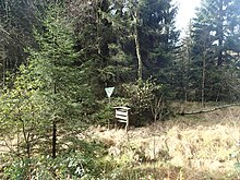
The Lister directly below its headwaters in the NSG Auf'm Ebbe in Meinerzhagen |
||
| Data | ||
| Water code | DE : 276646 | |
| location | Sauerland , Märkischer Kreis , North Rhine-Westphalia ( Germany ) | |
| River system | Rhine | |
| Drain over | Bigge → Lenne → Ruhr → Rhine → North Sea | |
| source | in the Ebbegebirge at Rothenstein 51 ° 7 '26 " N , 7 ° 40' 43" E |
|
| Source height | approx. 554 m above sea level NHN | |
| muzzle | at Hunswinkel in the Listertalsperre Coordinates: 51 ° 4 ′ 45 " N , 7 ° 47 ′ 44" E 51 ° 4 ′ 45 " N , 7 ° 47 ′ 44" E |
|
| Mouth height | 320 m above sea level NHN | |
| Height difference | approx. 234 m | |
| Bottom slope | approx. 12 ‰ | |
| length | 19 km | |
| Catchment area | 69.95 km² | |
| Discharge at the Börlinghausen A Eo gauge : 48 km² Location: 8.1 km above the mouth |
NNQ (08/03/1999) MNQ 1961/2010 MQ 1961/2010 Mq 1961/2010 MHQ 1961/2010 HHQ (12/04/1960) |
51 l / s 128 l / s 1.49 m³ / s 31 l / (s km²) 24.3 m³ / s 63.3 m³ / s |
| Left tributaries | Räupger Bach, Ebbe (Blomberger Bach), Hemche (Hösinghauser Bach), Tutmicke, Eickelsbieke, Heimche, Biecke | |
| Right tributaries | Husmicke, Krummenau, | |
| Reservoirs flowed through | Listertalsperre (estuary waters) | |
| Medium-sized cities | Meinerzhagen | |
The Lister is a 19 km long, northwest and left tributary of the Bigge in the urban area of Meinerzhagen . It flows in the North Rhine-Westphalian Märkischer Kreis ( Germany ), flows through the Lister dam and feeds the Biggesee .
course

The Lister runs within the Sauerland in the Sauerland-Rothaargebirge Nature Park . It rises within the Ebbe Mountains, north of the Rothenstein mountain (approx. 600 m above sea level ). Your in bog Groundless preferred source lies in the nature reserve Auf'm low tide / low tide Moore, located between the city of Meinerzhagen m belonging hamlets Schürfelde and cams in the north and the village Willertshagen the south about 870 east-northeast of the on the motorway 45 (Sauerlandlinie) located Resting place Rothenstein (540 to 580 m ) spreads to about 560 m height.
The Lister flows in a predominantly south-easterly direction between the Ebbegebirge in the north-west and the Listertalsperre in the south-east through the Ebbegebirge Nature Park: Initially, the stream heads south towards the village of Willertshagen, a few kilometers east of Meinerzhagen, which it passes immediately to the east.
Henceforth, the Lister flows through numerous hamlets in the city of Meinerzhagen and among other things, the district Krummenerl to the district Hunswinkel where they coming from the west in the Listertalsperre ( 319.52 m ) flows , a tributary of the Bigge -carrying reservoir Biggesee , which directly meets the air side of the Lister dam.
Individual evidence
- ↑ a b Topographic map 1: 2500 (Ministry for Climate Protection, Environment, Agriculture, Nature and Consumer Protection of the State of North Rhine-Westphalia), on geoserver.nrw.de
- ↑ a b c Ministry for the Environment, Nature Conservation, Agriculture and Consumer Protection NRW , on Niederrhein.nrw.de
- ↑ German hydrological yearbook Ruhr / Börlinghausen 2010 (PDF, 14.8 kB), on talsperrenleitzentrale-ruhr.de
