Lukino Selo
|
Лукино Село Lukino Selo Lukácsfalva |
||||
|
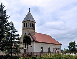
Catholic Church in Lukino Selo |
||||
|
||||
| Basic data | ||||
|---|---|---|---|---|
| State : | Serbia | |||
| Province : | Vojvodina | |||
| Okrug : |
Srednji Banat |
|||
| Opština : | Zrenjanin | |||
| Coordinates : | 45 ° 18 ′ N , 20 ° 25 ′ E | |||
| Height : | 70 m. i. J. | |||
| Area : | 53.4 km² | |||
| Residents : | 598 (2002) | |||
| Population density : | 11 inhabitants per km² | |||
| Telephone code : | (+381) 023 | |||
| Postal code : | 23 224 | |||
| License plate : | ZR | |||
| Structure and administration | ||||
| Community type: | Village | |||
Lukino Selo ( Serbian - Cyrillic Лукино Село , Hungarian Lukácsfalva , German Lukasdorf ) is a place in the Serbian Banat and belongs to the administrative area of the city of Zrenjanin .
Demographics
According to a census from 2002, a total of 477 people of legal age in 217 households live in Lukino Selo . The average age of the residents is 39.4 years (37.3 for the male and 41.5 for the female population ). The village has a Hungarian majority and has a steadily decreasing population .
| Population development | |
| year | Residents |
| 1948 | 1007 |
| 1953 | 757 |
| 1961 | 876 |
| 1971 | 722 |
| 1981 | 703 |
| 1991 | 643 |
| 2002 | 598 |


