Lundazi
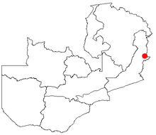
Lundazi is a place in Zambia with around 11,637 inhabitants (2006 estimate). It is the seat of the administration of the district of the same name with 236,833 inhabitants (2000 census) and is located east of the Luangwa in the eastern province of Zambia near the border with Malawi . The largely paved road from Chipata to Isoka runs through the village . Lundazi is important as a shopping destination.
politics
Lundazi is in a rural area. An agreement between Malawi and Zambia will convert the Nyika Plateau in both countries, Vwaza Marsh Game Reserve and Kasungu National Park Malawi with the forest reserves of Lundazi, Mitenge, Mikuti, the Musa Langu hunting area and the Lukusuzi National Park Zambia into cross-border protected areas .
economy
Cross-border trade is important. The dominant tribe in Lundazi is, as on the Malawian side, the Ngoni . The nearby Mzimba , with its high economic growth, has a strong influence up to this point. Smuggling, but also the sale of agricultural products from Lundazi in Mzimba, is a constant political issue, as is migration. Limestone deposits can be found in the south and southwest of the Lundazi district . A quarry supplies Zambia with rubble stones . The quarries at Msoro Mission were used for lime extraction for agriculture until 1960.
Social
One problem is the regulation of the market within Zambia. It is cotton planted and harvested, must be delivered at fixed prices. The state determines the price. The farmers are not allowed to hold back cotton for their own use in order to spin and weave it. Second-hand clothing from Europe, which is much more expensive, is offered on the market.
Infrastructure
Lundazi is known as BOMA ( British Overseas Military Administration ) and today has a castle based on the Norman model - Lundazi Castle . Errol Button had it built as a guest house for government employees in the 1940s and named it Rumpelstiltskin . Today it is used as a hotel. The very extensive, tree-lined castle park offers an idyllic castle pond - but with hippos. There are also elementary and secondary schools as well as an unpaved, 1,400 meter long runway.
See also
- For a map with all districts and provinces see: Administrative division of Zambia
Web links
Coordinates: 12 ° 17 ' S , 33 ° 11' E

