Lutkho
| Lutkho | ||
|
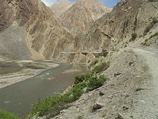
Garam Chashma Road above the Lutkho |
||
| Data | ||
| location | Khyber Pakhtunkhwa ( Pakistan ) | |
| River system | Indus | |
| Drain over | Kunar → Kabul → Indus → Indian Ocean | |
| source |
Hindu Kush 36 ° 3 ′ 36 ″ N , 71 ° 14 ′ 16 ″ E |
|
| Source height | approx. 4250 m | |
| Association with |
Mastuj zum Kunar Coordinates: 35 ° 54 ′ 9 " N , 71 ° 48 ′ 38" E 35 ° 54 ′ 9 " N , 71 ° 48 ′ 38" E |
|
| Mouth height | 1507 m | |
| Height difference | approx. 2743 m | |
| Bottom slope | approx. 34 ‰ | |
| length | 80 km | |
| Catchment area | 2500 km² | |
| Left tributaries | Siruk Gol, Arkari Gol | |
| Communities | Dung Gushten, Darband, Garam Chashma, Shogore, Rondur | |
The Lutkho (also Lotkoh or Garam Chashma ) is the right source river of the Kunar in the Pakistani province of Khyber Pakhtunkhwa .
The Lutkho rises near the Afghan border at an altitude of about 4250 m . From there it flows in a predominantly easterly direction in the northwest of the Chitral district through the Hindu Kush . A road ( Garam Chashma Road ) leads along the river to the 4300 m high Dorah Pass , which forms a transition to Badakhshan . The Arkari Gol flows into the river on the left above Shogore. Later the Lutkho turns south and meets the Mastuj 7 km north of Chitral . The Lutkho has a length of about 80 km. Its 4500 km² catchment area is bounded in the west and north by the watershed of the Hindu Kush main ridge, which also forms the state border with Afghanistan. Villages in the river valley of the Lutkho are Dung Gushten, Darband, Garam Chashma, Shogore and Rondur.
