
Manfa
| Manfa | |||||
|
|||||
| Basic data | |||||
|---|---|---|---|---|---|
| State : | Hungary | ||||
| Region : | Southern Transdanubia | ||||
| County : | Baranya | ||||
| Small area until December 31, 2012 : | Komló | ||||
| District since 1.1.2013 : | Komló | ||||
| Coordinates : | 46 ° 9 ' N , 18 ° 14' E | ||||
| Area : | 27.7 km² | ||||
| Residents : | 865 (Jan. 1, 2011) | ||||
| Population density : | 31 inhabitants per km² | ||||
| Telephone code : | (+36) 72 | ||||
| Postal code : | 7304 | ||||
| KSH kódja: | 33923 | ||||
| Structure and administration (status: 2018) | |||||
| Community type : | local community | ||||
| Structure : | Mánfa, Budafa | ||||
| Mayor : | Zsolt Takács (independent) | ||||
| Postal address : | Petőfi Sándor u. 21 7304 Mánfa |
||||
| Website : | |||||
| (Source: A Magyar Köztársaság helységnévkönyve 2011. január 1st at Központi statisztikai hivatal ) | |||||


Mánfa is a Hungarian community in the county Komló in Baranya . The district of Budafa belongs to the municipality .
Geographical location
Mánfa is about five kilometers south of the town of Komló on the small river Baranya-patak .
history
Mánfa was created in 1949 through the merger of the places Mánfa and Pécsbudafa . From 1958 the place belonged to the city of Komló and has been an independent municipality since 1992.
Attractions
- Cave in Mánfai-kőlyuk
- Roman Catholic Church Sarlós Boldogasszony , originally built in the 12th century, later rebuilt and expanded several times
- Roman Catholic Chapel Szent István király
- Sarlós Boldogasszony statue, created by Gyula Kutasi
- World War Monuments ( I. és II. Világháborúban elesettek emlékére )
traffic
Main road 66 and regional road 6534 pass through Mánfa. The nearest train station is in Komló.
photos
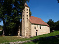
Roman Catholic Sarlós Boldogasszony Church
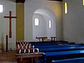
Interior of the church
Interior of the church

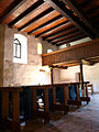
Gallery of the church with harmonium
_8.jpg)

_7.jpg)

Web links
Commons : Mánfa - collection of images, videos and audio files
- Official website ( Hungarian )
- Mánfa község címere (Hungarian)