
Magyaregregy
| Magyaregregy | |||||
|
|||||
| Basic data | |||||
|---|---|---|---|---|---|
| State : | Hungary | ||||
| Region : | Southern Transdanubia | ||||
| County : | Baranya | ||||
| Small area until December 31, 2012 : | Komló | ||||
| District since 1.1.2013 : | Komló | ||||
| Coordinates : | 46 ° 15 ' N , 18 ° 18' E | ||||
| Area : | 26.81 km² | ||||
| Residents : | 731 (Jan. 1, 2011) | ||||
| Population density : | 27 inhabitants per km² | ||||
| Telephone code : | (+36) 72 | ||||
| Postal code : | 7332 | ||||
| KSH kódja: | 29753 | ||||
| Structure and administration (as of 2017) | |||||
| Community type : | local community | ||||
| Mayoress : | Ildikó Fülöpné Rákosa (independent) | ||||
| Postal address : | Kossuth Lajos u. 73 7332 Magyaregregy |
||||
| Website : | |||||
| (Source: A Magyar Köztársaság helységnévkönyve 2011. január 1st at Központi statisztikai hivatal ) | |||||


Magyaregregy ( Croatian Gređa ) is a Hungarian community in the county Komló in Baranya .
Geographical location
Magyaregregy is located on the edge of the eastern Mecsek Mountains ( Keleti-Mecsek ) on the small river Völgységi-patak , about 15 kilometers north of the town of Komló .
Parish partnership
Attractions
- Márévár castle ruins , originally built in the 13th century in Gothic style; there is a museum on regional history
- Village museum ( Falumúzeum ) with local history collection in Arnold-ház
- Nature trail ( Vár-völgyi földtani tanösvény )
- Kisboldogasszony Roman Catholic Church , built in the 19th century
photos

Aerial view of the castle ruins

Inside the castle ruins
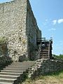
Ascent to the castle ruins


traffic
Road 6541 runs through Magyaregregy. The nearest train station is to the northwest in Szalatnak .
Web links
- Official website ( Hungarian )
- Magyar Egregy in A Pallas nagy lexikona (Hungarian)
- Stockum - Partnerkapcsolat Stockum és Magyaregregy között (Hungarian)