Mühlbach (Chiemsee, Prien)
| Mühlbach | ||
|
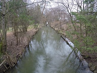
Before the mouth of the Mühlbach in the Chiemsee |
||
| Data | ||
| Water code | EN : | |
| location | Bavaria | |
| River system | Danube | |
| Drain over | Chiemsee → Alz → Inn → Danube → Black Sea | |
| source | Derived from Prien 47 ° 51 ′ 9 ″ N , 12 ° 20 ′ 10 ″ E |
|
| Source height | approx. 539 m above sea level NHN | |
| muzzle | north in the Chiemsee of Irschener angle coordinates: 47 ° 50 '14 " N , 12 ° 22' 24" O at 47 ° 50 '14 " N , 12 ° 22' 24" O |
|
| Mouth height | 518 m above sea level NHN | |
| Height difference | approx. 21 m | |
| Bottom slope | approx. 4.9 ‰ | |
| length | approx. 4.3 km | |
| Right tributaries | Egerndorfer Bach , Reitbach | |
The Mühlbach is probably a partially artificial river in the Bavarian district of Rosenheim that is fed by a weir from the Prien . In addition to the tributary from the Prien, the Mühlbach has other natural tributaries. The Mühlbach is stocked with brown trout , grayling , rainbow trout and char .
