Maclear (South Africa)
| Maclear | ||
|---|---|---|
|
|
||
| Coordinates | 31 ° 4 ′ S , 28 ° 21 ′ E | |
| Basic data | ||
| Country | South Africa | |
| Eastern Cape | ||
| District | Joe Gqabi | |
| ISO 3166-2 | ZA-EC | |
| local community | Elundini | |
| height | 1257 m | |
| Residents | 8559 (2011) | |
| founding | 1876 | |
|
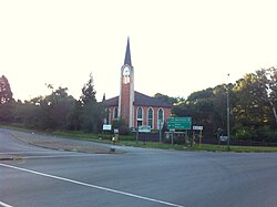
Dutch Reformed Church in Maclear
|
||
Maclear is a city in the Eastern Cape Province of South Africa . It is the administrative center of the municipality Elundini Local Municipality in the district of Joe Gqabi District Municipality .
geography
Maclear has 8,559 inhabitants. The Mooi River (also Nqanqaru ) flows on the eastern edge of the city . To the southwest is the city of Ugie . The city is located in the foothills ( Foothills ) of the Drakensberg .
history
The city was founded in 1876 towards the end of the border wars as a military camp under the name of Nqanqaru Drift. In 1882 the place was named after the South African astronomer Sir Thomas Maclear (1794–1879), who surveyed the Cape Colony . In 1916 Maclear received parish status.
Maclear was close to Homeland Transkei, which was dissolved in 1994 .
Economy and Transport
Tourism is one of the industries. These include people who fish trout . Attractions include rock paintings of the San and the Sivewright Bridge, a sandstone - viaduct of the railway line.
Maclear is at the junction of the regional roads R56, which connects Ugie and Elliot and Matatiele , and R396, which runs from Barkly East in the west to the N2 in the east. Maclear Airport is a little east of the city . Maclear is the end of a long branch line that begins in the Sterkstroom to the west and is only used for freight traffic.
Web links
- Official website (English)
Individual evidence
- ↑ 2011 census , accessed September 7, 2013
- ^ Sights in Maclear (English), accessed on September 7, 2013

