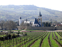
Mainz Mountain (Ingelheim)
| Mainz mountain | ||
|---|---|---|
|
The gently curved summit of the Mainz mountain . On the right in the background the Taunus , on the other side of the Rhine |
||
| height | 249.1 m above sea level NHN | |
| location | near Ingelheim am Rhein ; District of Mainz-Bingen , Rhineland-Palatinate ( Germany ) | |
| Mountains | Rhenish Hessian hill country | |
| Coordinates | 49 ° 57 '28 " N , 8 ° 7' 40" E | |
|
|
||

The Mainzer Berg is an elevation of the Rheinhessen hill country and at 249.1 m above sea level. NHN is the highest in the urban area of Ingelheim am Rhein in the Rhineland-Palatinate district of Mainz-Bingen .
geography
location
The Mainzer Berg is a northern branch of the Rheinhessen plateau between Ingelheim am Rhein in the north and Alzey in the south. Its peak is 4.6 km southeast of the in Nieder-Ingelheim standing church hall on the border southwest of the survey nearby municipality Schwabenheim an der Selz . To the west-northwest is in the valley of the Selz , which flows through Ingelheim at Frei-Weinheim into the Rhine , Ober-Ingelheim with the castle church there . In the same river valley, west-southwest of the elevation, lies the Ingelheim district of Großwinternheim . Wackernheim is located north of the summit region .
The Mainzer Berg belongs to the Ingelheim district . To the east, the landscape leads to Mainz-Layenhof and to the south to Essenheim and Elsheim . It slopes gently to the north past Ingelheim, Wackernheim and Heidesheim towards the Rhine. To the west, across the Selz, lies the Westerberg ( 247.5 m ).
Natural allocation
The Mainzer Berg belongs to the physiographic feature unit group Northern Upper Rhine lowland (no. 22) in the main unit Rhenish-Hessian Hills (227) and in the subunit Northern Tablelands (227.1) for the eastern plateau (227,130) of the natural environment eastern plateau and Bretzenheimer height (227.13) . Its western flank falls in the Selztal subunit (227.2) into the Lower Selztal natural area (227.20).
Mountain heights and crests
Mainzer Berg is the name given to two peaks lying next to one another on topographic maps , the elevations of which exceed the 240 m height line . About 780 m west-northwest of its summit ( 249.1 m ), which is located near a shooting range , is a 247.8 m high point, which is sometimes given as the highest point on the mountain.
Viticulture
The north and west flanks of the Mainz Mountain are characterized by vineyards typical of Rheinhessen . Because of the low average rainfall, a lot of ecological viticulture is practiced. The vineyards are on the elevation :
- in the north: Rabenkopf, Schwalben, Steinberg around Wackernheim; Lottenstück, Red Cross, Höllenweg, Steinacker, Pares, Horn around Ingelheim
- in the west: Deceiver's path, church piece, castle hill, sunny slope around Ingelheim; Heilighäuschen, Bockstein, monastery brother around Groß-Winternheim; Elsheimer Blume and Elsheimer Bockstein
Attractions
- Remains of the Ingelheimerhausen monastery , today Haxthäuserhof
- Windhäuser Hof near Elsheim, interesting cross-vaulted stables
Individual evidence
- ↑ a b c d Map service of the landscape information system of the Rhineland-Palatinate nature conservation administration (LANIS map) ( notes )
literature
- Topographic map Ingelheim am Rhein , sheet 6014, scale = 1: 25,000, published by the State Office for Surveying and Geographic Base Information Rhineland-Palatinate , ISBN 3-89637-076-6

