Westerberg (Rheinhessen)
| Westerberg | ||
|---|---|---|
|
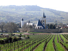
The Westerberg near Großwinternheim |
||
| height | 247.5 m above sea level NHN | |
| location | near Ingelheim am Rhein ; District of Mainz-Bingen , Rhineland-Palatinate ( Germany ) | |
| Mountains | Rhenish Hessian hill country | |
| Coordinates | 49 ° 56 '38 " N , 8 ° 2' 17" E | |
|
|
||

The Westerberg is at 247.5 m above sea level. NHN is the second highest elevation in the urban area of Ingelheim am Rhein in the Rhineland-Palatinate district of Mainz-Bingen after the Mainzer Berg ( 249.1 m ) .
geography
location
The Westerberg is located in the north of the Rheinhessen hill country southwest of Ingelheim am Rhein . It separates the districts of Ingelheim in the valley of the Selz in the east and Gau-Algesheim in the valley of the Welzbach in the west. The main part of the survey is in the Ingelheim area . The Gau-Algesheim community has a share in this with the towns of Gau-Algesheim, Appenheim , Nieder-Hilbersheim , Bubenheim and Schwabenheim an der Selz .
Natural allocation
The Westerberg belongs to the natural area main unit group Northern Upper Rhine Lowland (No. 22), in the main unit Rheinhessisches Tafel- und Hügelland (227) and in the subunit Nördliches Tafelland (227.1) to the natural area Rheinhessische Randstufe (227.10). Its eastern flank falls in the Selztal subunit (227.2) into the Lower Selztal natural area (227.20).
geology
Geologically, the Westerberg is an extension of the Rheinhessen plateau between Alzey and Ingelheim. The slopes of the mountain are characterized by the vineyards typical of Rheinhessen , the most prominent locations of which are the Appenheim Hundertgulden and the Schloss Westerhaus location . The floor contains floor ores that were even mined in the second half of the 19th century.
Attractions
- Bismarck tower (approx. 212 m high) with a view over the knee of the Rhine
- Richard height, striking viewpoint on the western slopes of the mountain with a small shelter, popularly known as "GAGA" ( G ebrüder A Venarius G au- A called lgesheim), and a panoramic image (200 x 20 cm) with a view to Rhein and Allies
- Westerhaus Castle , stud farm and largest farm in Rheinhessen
Individual evidence
- ↑ a b Map service of the landscape information system of the Rhineland-Palatinate Nature Conservation Administration (LANIS map) ( notes )
literature
- Topographic map Ingelheim am Rhein , sheet 6014, scale = 1: 25,000, published by the State Office for Surveying and Geographic Base Information Rhineland-Palatinate , ISBN 3-89637-076-6

