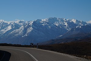
Maja e Hekurave
| Maja e Hekurave | ||
|---|---|---|
|
The mountain seen from the east |
||
| height | 2559 m above sea level A. | |
| location | Albania | |
| Mountains | Albanian Alps | |
| Dominance | 6 km → Maja Grykat e Hapëta | |
| Notch height | 459 m ↓ Qafa e Droçkës | |
| Coordinates | 42 ° 23 '8 " N , 19 ° 58' 12" E | |
|
|
||
| Type | Ridges | |
| rock | Dolomite lime | |
|
Aerial view from the northwest with the Maja e Hekurave on the right in the middle of the picture, the Valbonatal at the bottom left and the Maja Grykat e Hapëta in the middle of the picture below |
||
The Maja e Hekurave is 2559 m above sea level. A. or even 2561 m above sea level. A. high summit of the mountain range Mali i Hekurave (seldom also called Hekuravestock ) in the Albanian Alps in northern Albania . It is one of the ten highest peaks in the mountains.
The Maja e Hekurave rises between the basin of Nikaj-Mërtur in the southwest and the Valbonatal , which forms a wide arc in the north and northeast, and then flows into the wider valley of Tropoja in the south . The Valbona flows from there to the southwest towards the Drin . Beyond the Qafa e Droç (k) ës pass in the north-west and the Motina valley rises the Maja Grykat e Hapëta massif ( 2625 m above sea level ). To the south, the massif stretches to Maja e Mërturit ( 1757 m above sea level ), which then drops steeply to the Drin. To the north of this mountain, the massif is interrupted by the Qafa e Kolçit pass ( 1130 m above sea level ), but then climbs steeply to Maja e Dhive ( 2334 m above sea level ). A ridge leads from the top of the Maja e Hekurave to the northeast to the Maja e Zezë ( 2421 m above sea level ). In the west, the Maja e Hekurave is upstream of the Maja e Alshinës ( 2295 m above sea level ), in the east the Maja Lugu i Thiut ( 2109 m above sea level ) forms the end of the massif. The karst block around the summit is strongly fissured with many karen and a mountain lake south of the Maja Lugu i Thiut, the Liqeni i Panarit resp. Markajsee at approx. 1400 m above sea level. A. Akademia e Shkencave e RPSSH (ed.): Gjeografia fizike e Shqipërisë . tape II . Tirana 1990, p. 73-75 .
“This river [Curaj] and the Valbona are far from each other. That is why the mighty limestone parcels of the North Albanian table now build a massive, plateau-like mountain range, the Maja e Hekurave., It is only slightly subdivided by the tributary and original valleys of the Valbona. But its peaks are sharpened by intensive ice age glaciation. "
The town of Bajram Curr lies on the south-eastern slopes of the massif below the Maja Lugu i Thiut , and the village of Dragobia in the north in the Valbona valley.
The name Maja e Hekurave includes the Albanian word hekur , which means iron . A legend connects the knife-like peaks with the biblical flood : Noah's Ark was pinned in the heights of the Maja e Hekurvae and connected to the iron chain of the anchor.
There is a metal construction on the summit, presumably the remains of a triangulation pyramid . Certainly derive the name of the mountain from it, but it is likely to be older, as it can already be found in publications from the time of the first measurements.
Web links
- Ascent report on hikr.org (with photos)
- Summit panorama on YouTube
Individual evidence
- ↑ Official map 1: 50,000 of the military cartographic office of Albania, sheet K-34-52-D, 2nd edition, Tirana 1988
- ↑ a b Perikli Qiriazi: Gjeografia Fizike e Shqipërisë . Shtëpia Botuese e Librit Universitar, Tirana 2006, ISBN 99927-0-397-0 , Shkumbini, p. 169 .
- ↑ a b Herbert Louis : Albania. A knowledge of the country mainly because of my own travels . Published by J. Engelhorn's successors in Stuttgart, Berlin / Stuttgart March 1927, p. 152 .
- ↑ ATSH: Maja e Hekurave në Alpet Shqiptare midis legjendës dhe realitetit. In: Koha.net. December 18, 2017, accessed January 8, 2018 (Albanian).
- ↑ Nitt Gashi: The Iron Summit - Maja e Hekurave (2561m). In: hikr.org. August 29, 2017. Retrieved January 8, 2018 .


