Mallee Highway
| Mallee Highway | |
|---|---|

|
|
| map | |
| Basic data | |
| Operator: | Transport SA |
| further operator: | Roads and Maritime Services |
| Start of the street: |
Tailem Bend ( SA ) ( 35 ° 17 ′ S , 139 ° 29 ′ E ) |
| End of street: |
Piangil ( VIC ) ( 35 ° 3 ' S , 143 ° 20' O ) |
| Overall length: | 377 km |
|
States : |
|
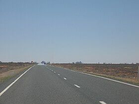
| Mallee Highway with a mirage | |
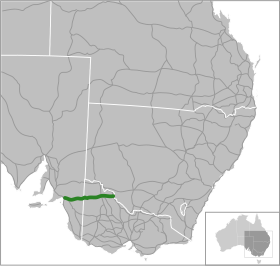
The Mallee Highway is a trunk road in the southeast of Australia . It connects the Dukes Highway in Tailem Bend in South Australia with the Murray Valley Highway near Piangil in Victoria . It gets its name from the characteristic mallee vegetation of large parts of the surrounding area, which is also known as Murray Mallee .
course
The highway begins in the west at Tailem Bend, where it meets the Dukes Highway (NA8). From there it runs east and shortly after Pinnaroo passes the border to Victoria. The highway used to end on the Calder Highway (A79) in Ouyen , today it continues and ends behind Piangil on the Murray Valley Highway (B400).
Important junctions and cities
|
Mallee Highway |
|||
| Westward | Distance to Adelaide (km) |
Distance to Swan Hill (km) |
East |
|
Dukes Highway to Bordertown and Melbourne Dukes Highway to Princes Highway via Tailem Bend and Adelaide |
|||
|
End of Mallee Highway |
100 | 414 |
Beginning of Mallee Highway |
| Coomandook Old Dukes Highway |
114 | 400 | Coomandook Old Dukes Highway |
| Tailem Bend-PINNAROO RAIL LINE |
152 | 362 | Tailem Bend-PINNAROO RAIL LINE |
| Lameroo | 199 | 315 | Lameroo |
| Tailem Bend-PINNAROO RAIL LINE |
208 | 306 | Tailem Bend-PINNAROO RAIL LINE |
|
further than |
233 | 281 |
Bordertown , Naracoorte Pinnaroo-Bordertown Road |
|
Bordertown , Naracoorte Pinnaroo-Bordertown Road |
|
||
|
|
239 | 275 | Pinnaroo |
|
Loxton , Renmark Pinnaroo-Loxton Road |
Loxton , Renmark Pinnaroo-Loxton Road |
||
| Pinnaroo |
further than |
||
|
SOUTH AUSTRALIA STATE BORDER VICTORIA |
|||
| PINNAROO RAIL LINE |
245 | 269 | PINNAROO RAIL LINE |
| PINNAROO RAIL LINE |
265 | 249 | PINNAROO RAIL LINE |
| Murrayville | 266 | 248 | Murrayville |
| PINNAROO RAIL LINE |
270 | 244 | PINNAROO RAIL LINE |
| PINNAROO RAIL LINE |
306 | 208 | PINNAROO RAIL LINE |
| Boinka | 307 | 207 | Boinka |
| Underbool | 326 | 188 | Underbool |
|
Patchewollock Walpeup-Patchewollock Road |
346 | 168 | Walpeup |
| Walpeup |
Patchewollock , Hopetoun Walpeup-Patchewollock Road |
||
| After Patchewollock , Hopetoun Ouyen-Patchewollock Road |
374 | 140 |
Patchewollock Ouyen-Patchewollock Road |
| PINNAROO RAIL LINE |
PINNAROO RAIL LINE |
||
| MILDURA RAIL LINE |
375.7 | 138.3 | Ouyen |
| MILDURA RAIL LINE |
|||
|
further than |
After Ballarat ; Bendigo , Melbourne Calder Highway |
||
| After Ballarat ; Bendigo , Melbourne Calder Highway |
|
||
|
|
375.8 | 138.2 |
Red Cliffs , Mildura Calder Highway |
|
Red Cliffs , Mildura Calder Highway |
|||
| Ouyen |
further than |
||
| Manangatang | 431 | 83 | Manangatang |
|
Sea Lake , Robinvale Robinvale-Sea Lake Road |
Robinvale , Sea Lake Robinvale-Sea Lake Road |
||
| ROBINVALE RAIL LINE |
ROBINVALE RAIL LINE |
||
| Piangil | 470 | 44 | Piangil |
|
Beginning of Mallee Highway |
472 | 42 |
End of Mallee Highway |
|
Murray Valley Highway to Robinvale and Sydney Murray Valley Highway to Swan Hill and Melbourne |
|||
Web links
Commons : Mallee Highway - collection of pictures, videos and audio files

