Malmesbury (South Africa)
| Malmesbury | ||
|---|---|---|
|
|
||
| Coordinates | 33 ° 27 '47 " S , 18 ° 43' 49" E | |
| Basic data | ||
| Country | South Africa | |
| Western cape | ||
| District | West coast | |
| ISO 3166-2 | ZA toilet | |
| local community | Swartland | |
| height | 128 m | |
| surface | 13.1 km² | |
| Residents | 10,299 (2011) | |
| density | 789.2 Ew. / km² | |
| founding | 1743 | |
|
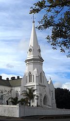
The Dutch Reformed Church
|
||
Malmesbury is a city in the Western Cape Province of South Africa . It is the administrative seat of the Local Municipality Swartland in the West Coast District .
geography
In 2011, Malmesbury had a population of 10,299; together with the immediately neighboring settlements, especially Ilinge Lethu and Wesbank, it has 35,897 inhabitants. Malmesbury is the capital of the Swartland region and is around 70 kilometers north of Cape Town .
history
In 1703 the first farms were set up at the current location in the valley of the Diep River ; The place was founded in 1743. The fifth Dutch Reformed church in the history of South Africa was born in Malmesbury. The former place of Zwartlands Kerk was renamed Malmesbury in 1829 in honor of James Harris, 1st Earl of Malmesbury . The earl was the father-in-law of the then governor of the Cape Colony , Sir Lowry Coles . In 1860 Malmesbury received parish status.
On September 29, 1972, a serious railway accident occurred near Malmesbury when a passenger train with nine cars derailed . About 100 people died.
Economy and Transport
Malmesbury is dominated by agriculture, mainly through grain cultivation, viticulture and sheep and poultry farming. The National Route 7 runs in a north-south direction directly past Malmesbury and connects Moorreesburg in the north with Cape Town in the south, the R45 runs northwest towards Saldanha and southeast to Paarl , while the R46 leads to Ceres in the east. Finally, the R315 connects Malmesbury with the coastal towns to the west, such as Darling .
Malmesbury has a head station on the railway line (Cape Town-) Kraaifontein- Bitterfontein which is operated in the freight.
The Malmesbury Correctional Center is in town.
Others
The Malmesbury Group is the area's oldest rock formation. It comes from the late Precambrian and consists of greywacke and slate .
Web links
- Tourist information at sa-venues.com (English)
Individual evidence
- ↑ 2011 census , accessed on August 17, 2015
- ↑ Mount Royal Golf & Country Estate , Wesbank , Malmesbury and Ilinge Lethu (added together), accessed August 17, 2015
- ↑ a b c Description of the Local Municipality at localgovernment.co.za (English), accessed on August 17, 2015
- ↑ a b portrait at sa-venues.com (English), accessed on August 17, 2015
- ^ Peter WB Semmens: Catastrophes on rails. A worldwide documentation. Transpress, Stuttgart 1996, ISBN 3-344-71030-3 , p. 178.
- ↑ Geology of Cape Town on the University of Cape Town website , accessed on August 17, 2015

