
Malta (Lieser)
| Malta | ||
 The Malta near Gmünd |
||
| Data | ||
| location | Carinthia , Austria | |
| River system | Danube | |
| Drain over | Lieser → Drau → Danube → Black Sea | |
| origin |
Galgenbichlspeicher 47 ° 3 ′ 55 ″ N , 13 ° 21 ′ 10 ″ E |
|
| Source height | approx. 1655 m above sea level A. | |
| muzzle | near Gmünd in Carinthia in the Lieser coordinates: 46 ° 54 '9 " N , 13 ° 31' 58" E 46 ° 54 '9 " N , 13 ° 31' 58" E |
|
| Mouth height | 732 m above sea level A. | |
| Height difference | approx. 923 m | |
| Bottom slope | approx. 34 ‰ | |
| length | approx. 27.5 km | |
| Catchment area | 268.6 km² | |
| Discharge at the Sandriesen A Eo gauge : 148.7 km². Location: 1.58 km above the mouth |
NNQ (02.26.1986) MNQ 1976–2010 MQ 1976–2010 Mq 1976–2010 MHQ 1976–2010 HHQ (02.09.1965) |
130 l / s 1 m³ / s 3.51 m³ / s 23.6 l / (s km²) 63.5 m³ / s 280 m³ / s |
| Left tributaries | Fallbach, Feistritzbach | |
| Right tributaries | Hochalmbach, Gößbach | |
| Small towns | Gmünd in Carinthia | |
| Communities | Malta | |
The Malta ( ahd. Malt , "gentle, mild") is a river in Carinthia that stretches over 38 km through the Maltatal . The Malta Valley is a popular excursion destination because of its large number of waterfalls ("Valley of the falling waters") and is largely part of the municipality of Malta .

The Fallbach waterfall
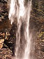
The Fallbach waterfall
The Fallbach waterfall

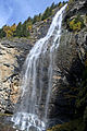
The Melnikfall, 300 m high


As a north-western tributary of the Lieser , it flows into the same at Gmünd and has an average water flow rate of around 3.5 m³ / s. It rises in the Hohe Tauern east of the Ankogel group . Origin of Malta was once the confluence of the wholesale and retail misery creek, today is the lower barrage of Malta power stations , the memory Galgenbichl, regarded as the beginning.
Energy generation

The Malta is part of the Maltakraftwerke , the most powerful power plant group in Austria . The Kölnbreinsperre completely changed the original character of the river through the water drainage. The discharges will reduce the natural catchment area by 117.3 km².
Web links
Individual evidence
- ↑ a b c KAGIS - Carinthia Atlas
- ↑ Federal Ministry of Agriculture, Forestry, Environment and Water Management (Ed.): Area directory of the Austrian river basins: Draugebiet. Contributions to the hydrography of Austria, issue No. 59, Vienna 2011, p. 36 ( PDF; 3.5 MB )
- ↑ a b Federal Ministry of Agriculture, Forestry, Environment and Water Management (ed.): Hydrographisches Jahrbuch von Österreich 2011. 119th volume. Vienna 2013, p. OG 336, PDF (12.9 MB) on bmlrt.gv.at (yearbook 2011)