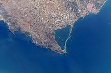
Mar Menor
| data | |
|---|---|
| Surname: | Mar Menor |
| Location: | Murcia region , Spain |
| Coordinates: | 37 ° 43 ′ 8 ″ N , 0 ° 47 ′ 14 ″ W. |
| Water level: | 0 msnm |
| Area: | approx. 170 km² |
| maximum depth: | approx. 7 m |
| Shore length: | 73 km |
| Islands: |
Isla Perdiguera Isla Mayor (del Barón) Isla Rondella Isla del Ciervo Isla del Sujeto |
The Mar Menor ( Spanish for 'Smaller Sea') is a saltwater lagoon in the Spanish region of Murcia .
geography
location
The lagoon is separated from the Mediterranean by the La Manga (translated: "sleeve") spit, 22 kilometers long and 100 to 1,200 meters wide . The salt content is 42–47 g / l. In comparison, the Mediterranean has a concentration of 36–37 g / l.
The length of its inland coast is 73 km. The deepest point is about seven meters, but these are only small areas. For the most part, the depth is around two meters.
It is linked to the Mediterranean (in Murcia also called "Mar Mayor") through the weirs in La Torre and El Ventorrillo and through the channels El Estacio and Marchamalo .
geology
The latest surveys carried out by the University of Murcia (1995) show that sludge deposits contain high percentages of the cations calcium , magnesium and potassium as well as the anions chloride and sulfate , which are far above the values to be expected in such salty water. Because of this, the mud is said to have a therapeutic effect based on its great ability to absorb toxic substances and its mineralizing effect.
Flora and fauna
Due to the special conditions that the Mar Menor has, there are flora and fauna that differ considerably from the open Mediterranean.
I.a. the following types can be found:
- Sea bream
- Squids (spanish jibias )
- Groupers
- Flamingos (especially at the salt flats )
environmental Protection
The lagoon was in 1982 by the United Nations for Specially Protected Areas of Mediterranean Importance declared and is still on the UNEP managed SPAMI list.
However, there are major problems including with the water sports practiced on a large scale . Furthermore, La Manga is a single sealed area where it is difficult to find a vacant spot at all.
In 2019 the lake overturned , which was demonstrated by the massive deaths of the animals previously living in it due to the shortage of oxygen. The regional government of Murcia sees the reason for this in the fresh water, sediments and fertilizers that were brought in by the storm in September 2019 . The Spanish department of the World Wide Fund for Nature (WWF) also blamed "excessive agricultural and urban development and the inaction of those responsible for politics" for this.
In August 2021, after a heat wave, there was another mass extinction of the fauna in the lagoon. In protest against the fact that nothing is being done about the intensive agriculture in the immediate vicinity of the lagoon, which is the main cause of the problems, 70,000 people then formed a 73-kilometer human chain around the entire lagoon.
Sports
Due to the location, which is particularly exposed to the wind and the shallow water depth and the resulting low waves , the Mar Menor is ideal for numerous types of water sports . The "Copa Española", the Spanish kayak championship, takes place there every year .
Panorama La Manga del Mar Menor
Web links
Individual evidence
- ↑ Reiner Wandler: Animals die in Europe's largest lagoon: fish and crabs suffocate. In: taz.de . October 21, 2019, accessed January 19, 2020.
- ↑ Mar Menor in Spain: huge fish deaths in Europe's largest saltwater lagoon. In: rnd.de. August 23, 2021, accessed August 30, 2021 .
- ↑ 73 kilometers long human chain around the contaminated lagoon. In: faz.net. August 28, 2021, accessed August 30, 2021 .

