
Marklowice (Cieszyn)
| Marklowice | |||
|---|---|---|---|
 Help on coat of arms |
|
||
| Basic data | |||
| State : | Poland | ||
| Voivodeship : | Silesia | ||
| Powiat : | Cieszyn | ||
| Gmina : | Cieszyn | ||
| Geographic location : | 49 ° 47 ' N , 18 ° 36' E | ||
| Residents : | 590 (1997) | ||
| Postal code : | 43-400 | ||
| Telephone code : | (+48) 33 | ||
| License plate : | SCI | ||

Marklowice ( German Marklowitz ) is a district of Cieszyn in the powiat Cieszyński of the Silesian Voivodeship in Poland .
geography
Marklowice is located on the right bank of the Olsa River in the Silesian Foothills ( Pogórze Śląskie ) , about four kilometers north of the city center.
In 1910 the village had an area of 216 hectares . Neighboring towns: Pogwizdów in the north, Hażlach (Parchów) and Kalembice in the east, Boguszowice in the south. Marklowice borders the Czech Republic ( Chotěbuz ) in the west .
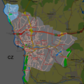
Location of Marklowice in Cieszyn

history
The place was first mentioned in 1523 as Marklowicze . The name is patronymically derived from the German first name Mark (e) l (≤ Markwart ) with the typical patronymic word ending - (ow) ice.
Politically, the village originally belonged to the Duchy of Teschen , the feudal lordship of the Kingdom of Bohemia , and since 1526 it has belonged to the Habsburg monarchy .
After the abolition of patrimonial it became from 1850 a district of the municipality Pogwizdów in Austrian Silesia , district Teschen and judicial district Teschen. In 1900 Marklowice had 20 houses with 164 inhabitants, of which 158 (96.3%) Polish-speaking, 4 (2.4%) German-speaking, 2 (1.2%) Czech-speaking, 107 (65.2%) Protestant, 57 ( 34.8%) Roman Catholic. In 1910 there were 20 houses with 191 inhabitants, of which 173 (94%) Polish-speaking, 11 (6%) German-speaking, 115 (60%) Protestant, 69 (36%) Roman Catholic, 7 (3.7%) Israelite.
In 1920, after the collapse of the Austro-Hungarian monarchy and the end of the Polish-Czechoslovak border war , Marklowice became part of Poland. This was only interrupted by the occupation of Poland by the Wehrmacht in World War II .
The Polifarb factory was built between 1960 and 1965 . Marklowice was incorporated into the Cieszyns district in 1977.

Lutheran branch church of the parish of Cieszyn
Poly color


Web links
Individual evidence
- ↑ Study uwarunkowań i kierunków zagospodarowania przestrzennego miasta Cieszyna . In: www.um.cieszyn.bip-gov.info.pl . October 6, 2008. ( Page no longer available , search in web archives ) Info: The link was automatically marked as defective. Please check the link according to the instructions and then remove this notice.
- ↑ a b c Robert Mrózek: Nazwy miejscowe dawnego Śląska Cieszyńskiego . Uniwersytet Śląski w Katowicach , 1984, ISSN 0208-6336 , p. 114 (Polish).
- ↑ Marcin Żerański: Śląsk Cieszyński od Bielsko-Białej do Ostrawy. Przewodnik turystyczny . Pracownia na Pastwiskach, Cieszyn 2012, ISBN 978-83-933109-3-7 , p. 264 (Polish).
- ↑ a b Ludwig Patryn (ed): The results of the census of December 31, 1910 in Silesia , Opava 1912.
- ^ Idzi Panic: Śląsk Cieszyński w średniowieczu (do 1528) . Starostwo Powiatowe w Cieszynie, Cieszyn 2010, ISBN 978-83-926929-3-5 , p. 312 (Polish).
- ^ Community encyclopedia of the kingdoms and countries represented in the Imperial Council, edited on the basis of the results of the census of December 31, 1900, XI. Silesia . Vienna 1906 ( online ).