
Maryland County
| Maryland | ||
|---|---|---|
  |
||
| Symbols | ||
|
||
| Basic data | ||
| Country | Liberia | |
| Capital | Harper | |
| surface | 2297 km² | |
| Residents | 135,938 (2008) | |
| density | 59 inhabitants per km² | |
| founding | 1857 | |
| ISO 3166-2 | LR-MY | |

Coordinates: 4 ° 45 ′ N , 7 ° 45 ′ W
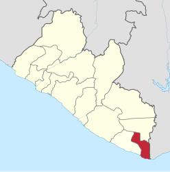
Maryland County is an administrative region ( county ) in Liberia , it has a size of 2 297 km² and had 135,938 inhabitants at the last census (2008).
The administrative region is divided into seven districts. The capital is Harper in the district of the same name.
| District | Ew. (2008) male |
Ew. (2008) female |
Ew. (2008) total |
|---|---|---|---|
| Gwelekpoken | 5,370 | 4,690 | 10,060 |
| Harper | 19,591 | 18,433 | 38.024 |
| Karluway # 1 | 4,501 | 3,993 | 8,494 |
| Karluway # 2 | 9,429 | 7,730 | 17,159 |
| Nyorken | 5,319 | 4,738 | 10,057 |
| Pleebo / Sodoken | 21,884 | 21,339 | 43,223 |
| Whojah | 4,761 | 4,160 | 8,921 |
| Maryland | 70,855 | 65,083 | 135.938 |
Maryland is located in the extreme southeast of Liberia on the Atlantic coast and on the border with the Republic of Ivory Coast .
history
On February 12, 1834, the colony of Maryland was founded in Liberia on the West African coast. The colonists chose the natural harbor on Cape Palmas as a settlement and trading post, from which the city of Harper developed into the capital of the colony. Thanks to the port, Maryland was an economically successful colony and gained state independence on May 29, 1854. Already on March 18, 1857 the independence was given up and the only president of this republic - Boston Jenkins Drayton - signed the accession treaty to the state of Liberia together with Joseph Jenkins Roberts . This union was preceded by a civil war known as Kru-War .
During the negotiations at the Berlin Congress of 1885, the previously indefinite course of the borders between the Republic of Liberia and the French and British colonial areas in West Africa was fixed by constitutional law. The coastline east of Cape Palmas, an essential part of the former colony of Maryland, was claimed by France and added to the colony of French West Africa .
Today, around 80 percent of the population works in agriculture, the main crops being rice and cassava. Inshore fishing and trading in tropical timber , palm oil products and rubber are also important .
politics
In the 2005 first Democratic Senate election after the Civil War, John Ballout and Gloria Maya Musu Scott , both candidates for the UP , were elected.
economy
In addition to fruit and coffee , the predominantly agricultural region primarily supplies rubber and palm oil products for export. With the city of Pleebo , a second economic center is emerging in the region - health center, police station, customs station and administration were newly built, there is a small power station and a radio station (Voice of Pleebo) in the village.
Individual evidence
- ^ NPHC 2008 Report Final. (PDF; 676 kB) In: Liberian Institute of Statistics and Geo-Information-Systems (LISGIS). Retrieved October 11, 2010 .
- ^ Liberia, Counties and Districts. (PDF; 0.4 MB) (No longer available online.) In: Liberian Institute of Statistics and Geo-Information-Systems (LISGIS). Formerly in the original ; accessed on October 11, 2010 (English). ( Page no longer available , search in web archives ) Info: The link was automatically marked as defective. Please check the link according to the instructions and then remove this notice.
- ^ Maryland Historical Society Library: Harper-Pennington Papers, 1701-1899, MS. 431
- ↑ Liberia. In: online portal www.worldstatesmen.org. Retrieved November 12, 2010 . (English topic portal: the present and former states of the world)
- ^ Ian Brownlie: African boundaries; a legal and diplomatic encyclopaedia . London 1979, ISBN 0-903983-87-7 , Ivory Coast – Liberia, pp. 358-370 .
- ↑ en: Wiki, article »Liberian general election, 2005« (the websites linked there for the election are no longer present).
Bomi | Bong | Gbarpolu | Grand Bassa | Grand Cape Mount | Grand Gedeh | Grand Kru | Lofa | Margibi | Maryland | Montserrado | Nimba | River Cess | River Gee | Sinoe