
Grand Cape Mount County
| Grand Cape Mount County | ||
|---|---|---|
  |
||
| Symbols | ||
|
||
| Basic data | ||
| Country | Liberia | |
| Capital | Robertsport | |
| surface | 5162 km² | |
| Residents | 127,076 (2008) | |
| density | 25 inhabitants per km² | |
| founding | 1844 | |
| ISO 3166-2 | LR-CM | |

Coordinates: 7 ° 10 ′ N , 11 ° 0 ′ W
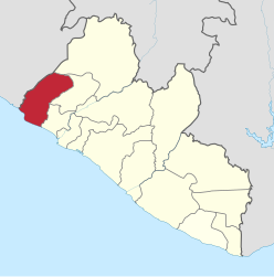
Grand Cape Mount County is an administrative region ( county ) in Liberia , it has a size of 5 162 km² and had 127,076 inhabitants at the last census (2008).
The name is derived from Cape Mount , a topographical point on the Atlantic coast . The administrative region is divided into five districts. The capital is Robertsport in the Commonwealth District.
| District | Ew. (2008) male |
Ew. (2008) female |
Ew. (2008) total |
|---|---|---|---|
| Commonwealth | 3,298 | 3,249 | 6,547 |
| Garwula | 13,668 | 13,268 | 26,936 |
| Golakonneh | 13,157 | 10,361 | 23,518 |
| Porkpa | 22,208 | 20,407 | 42,615 |
| Tewor | 13,348 | 14,112 | 27,460 |
| Grand Cape Mount | 65,679 | 61,397 | 127.076 |
The region is located in the far west of Liberia, borders Sierra Leone to the west and the Atlantic Ocean to the south .
politics
In the 2005 first Democratic Senate elections after the Civil War, Abel Momolu Massalay and James Kormah Momo - both of the NPP - were elected. The most important border crossing to neighboring Sierra Leone , Bo Waterside on the lower reaches of the Mano , was reopened in June 2007. The transportation route was an economic prerequisite for creating the Mano River Union as early as the 1970s .
Culture and sights
The Tubman Center of African Culture was opened in the capital Robertsport in 1975 , it served as a cultural meeting place and was equipped with an important collection of contemporary art. Today the building is in ruins on the western outskirts.
Individual evidence
- ^ NPHC 2008 Report Final. (PDF; 676 kB) In: Liberian Institute of Statistics and Geo-Information-Systems (LISGIS). Retrieved October 11, 2010 .
- ^ Liberia, Counties and Districts. (PDF; 0.4 MB) (No longer available online.) In: Liberian Institute of Statistics and Geo-Information-Systems (LISGIS). Formerly in the original ; accessed on October 11, 2010 (English). ( Page no longer available , search in web archives ) Info: The link was automatically marked as defective. Please check the link according to the instructions and then remove this notice.
- ↑ en: Wiki, article »Liberian general election, 2005« (the websites linked there for the election are no longer present).
- ^ NN: Border post re-open between Liberia and Sierra Leone. (No longer available online.) Deccan Herald, June 14, 2007, archived from the original on December 27, 2008 ; accessed on January 18, 2011 (English). Info: The archive link was inserted automatically and has not yet been checked. Please check the original and archive link according to the instructions and then remove this notice.
Bomi | Bong | Gbarpolu | Grand Bassa | Grand Cape Mount | Grand Gedeh | Grand Kru | Lofa | Margibi | Maryland | Montserrado | Nimba | River Cess | River Gee | Sinoe