Meßdorfer field
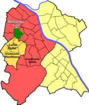
The Meßdorfer Feld is the largest contiguous open space in Bonn and is located in the west of the city.
geography
The field lies between Dransdorf in the north, Meßdorf in the southwest and west, Duisdorf in the south and Endenich in the east and northeast. On the edge of the Cologne Bay it belongs to the beginnings of the foothills and is at a similar height to most of the neighboring places, but after Dransdorf it drops off steeply with the Dransdorfer Berg . The field itself is not level, but has some small hills and waves. The area is about 150 to 170 hectares , depending on the boundary drawn . The field is cut through by the tracks of the Voreifelbahn , the Bonn Helmholtzstrasse stop is on its edge. Several farm, bike and footpaths cross the field, the tracks are crossed by the "Black Bridge" and "White Bridge". The Dransdorfer Bach flows in the west .
history
On the adjacent Steinweg road , Roman fragments were found in 1958 during canal construction work; the name goes back to a path built by the Romans across today's field. Agricultural use has been documented since the Middle Ages. The name Meßdorfer Feld is not a traditional field name , but just a modern name. In the past, the villages in the Bonn area were embedded in large agricultural and open spaces, and only when they grew together strongly and only the Meßdorfer field remained between them, this name came about.
When the railway opened in 1880, steam locomotives were in use. There was a steep incline at one of the bridges, so the trains were under heavy load and the soot turned the bridge black. This is how the name Black Bridge came about, the White Bridge was named so to make it easier to distinguish.
In 1911, paintings by August Macke and Hans Thuar were created showing the Meßdorfer Feld . At the southern end you can still find bomb fragments, remains of ammunition and occasionally even duds from the Second World War .
In the 1990s, the Meßdorfer Feld was considered as a location for the caesar research center .
Todays use
The Meßdorfer Feld is mainly used as an agricultural area for crops, including wheat, rye, barley, potatoes, vegetables, strawberries and beets. In between there are some areas overgrown with trees and bushes, the paths also serve as a local recreation area. However, the field is also important as a natural area, including the sand lizard , which, as a species in Appendix IV of the Fauna-Flora-Habitat Directive, must also be strictly protected outside of nature reserves. An expert report by the German Meteorological Service in Essen in 1990 highlighted the importance of the field for the Bonn climate by bringing cooler air from the foothills. On the north edge of the Endeicher there are test fields and the Astronomical Institute of the University of Bonn as well as the Max Planck Institute for Radio Astronomy , which were located here because of the once small development and therefore clear view.
future
The future of the Meßdorfer Feld was controversial for a long time. The majority of the area will be designated as an exclusive agricultural area after a land use plan change decided on June 30, 2005 by the Bonn city council, thus protected from development and preserved as an "open air corridor". For the southern end of the field, however, also called "Lorth-Zipfel" after the former Hardtberg District Mayor Gerhard Lorth , a development plan procedure was initiated under the name "Am Bruch" and the development plan was finally decided on October 25, 2006. The civil engineering work for the first construction phase began in spring 2009.
The Meßdorfer Feld was a project for the Regionale 2010 . The biological station, the former EXPO-2000 project "Hedges become houses - structures as tree works" on Dransdorfer Berg and an organic farm were integrated into existing facilities . There are also newly created hedges and other environmental projects. The Meßdorfer Feld became part of the “ Green C ” that extends beyond the city limits .
An example of the measures taken as part of the Regionale 2010 is the joint project of the city of Bonn and the Chamber of Agriculture of North Rhine-Westphalia, in which an 8000 square meter arable area was sown with various flowering plants in the form of brushstrokes.
Web links
Coordinates: 50 ° 43 '42.4 " N , 7 ° 3' 19.8" E
Individual evidence
- ↑ Brush strokes in the Meßdorfer field . General-Anzeiger, April 16, 2010, accessed January 19, 2016.

