Medicine Lodge River
| Medicine Lodge River | ||
|
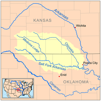
Location of the Medicine Lodge River in the catchment area of the Salt Fork Arkansas River |
||
| Data | ||
| Water code | US : 1095291 | |
| location | Kansas , Oklahoma (USA) | |
| River system | Mississippi River | |
| Drain over | Salt Fork Arkansas → Arkansas → Mississippi → Gulf of Mexico | |
| source | in Kiowa County, Kansas, 37 ° 30 ′ 51 " N , 99 ° 20 ′ 22" W. |
|
| muzzle | at Cherokee in the Salt Fork Arkansas River Coordinates: 36 ° 49 ′ 40 " N , 98 ° 19 ′ 38" W 36 ° 49 ′ 40 " N , 98 ° 19 ′ 38" W. |
|
| Mouth height |
355 m
|
|
| length | 163 km | |
The Medicine Lodge River is a 163-kilometer tributary of the Salt Fork Arkansas River in southern Kansas and northern Oklahoma . It belongs to the catchment area of the Mississippi River .
The river has its source in Kiowa County and then flows southeast through Barber County in Kansas and Alfalfa County in Oklahoma. It flows through the cities of Belvidere , Sun City and Medicine Lodge . About eight kilometers northeast of Cherokee it flows into the Salt Fork Arkansas River , a tributary of the Arkansas River .
It wasn't until 1968 that the United States Board on Geographic Names decided on "Medicine Lodge River" as the name of the river. According to the information in the Geographic Names Information System , it has historically been referred to as "A-ya-dalda-pa River", "Medicine Lodge Creek" and "Medicine River".
Individual evidence
- ↑ USGS - GNIS - Medicine Lodge River
- ^ Columbia Gazetteer of North America ( Memento of the original from November 28, 2005 in the Internet Archive ) Info: The archive link was automatically inserted and has not yet been checked. Please check the original and archive link according to the instructions and then remove this notice. (English)
- ^ Medicine Lodge River in the Geographic Names Information System of the United States Geological Survey
