Salt Fork Arkansas River
| Salt Fork Arkansas River | ||
|
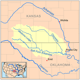
Map of the catchment area |
||
| Data | ||
| Water code | US : 470527 | |
| location | Kansas , Oklahoma (USA) | |
| River system | Mississippi River | |
| Drain over | Arkansas River → Mississippi River → Gulf of Mexico | |
| source | in Comanche County, Kansas, 37 ° 10 ′ 40 " N , 99 ° 21 ′ 48" W |
|
| muzzle | south of Ponca City in the Arkansas River Coordinates: 36 ° 35 ′ 35 " N , 97 ° 3 ′ 21" W 36 ° 35 ′ 35 " N , 97 ° 3 ′ 21" W |
|
| Mouth height |
271 m
|
|
| length | 309 km | |
| Left tributaries | Medicine Lodge River , Chikaskia River | |
| Reservoirs flowed through | Great Salt Plains Lake | |
|
The river at Tonkawa , Oklahoma |
||
The Salt Fork Arkansas River is a 309 km long tributary of the Arkansas River in southern Kansas and northern Oklahoma and belongs to the catchment area of the Mississippi River .
course
The river has its source in Comanche County in Kansas and initially flows southeast through the Counties Barbier , Kansas and Woods , Oklahoma. In Alfalfa County , the river is dammed to form Great Salt Plains Lake .
At Alva , the river makes an arc and then flows east through Oklahoma’s Alfalfa, Grant , Kay and Noble counties to its confluence . He passes the cities of Pond Creek , Lamont and Tonkawa .
Seven kilometers south of Ponca City , the river flows into the Arkansas River.
The major tributaries of the Salt Fork Arkansas River are the Medicine Lodge River in Alfalfa County and the Chikaskia River in Kay County.
Name variants
The Geographic Names Information System gives the Salt Fork Arkansas River the following previous names:
|
|
Individual evidence
- ↑ USGS - GNIS - Salt Fork Arkansas River
- ↑ Columbia Gazetteer of North America ( Memento of the original from March 16, 2006 in the Internet Archive ) Info: The archive link was automatically inserted and not yet checked. Please check the original and archive link according to the instructions and then remove this notice.
- ↑ Salt Fork Arkansas River # 1 in the Geographic Names Information System of the United States Geological Survey and Salt Fork Arkansas River # 2 in the Geographic Names Information System of the United States Geological Survey

