Sea basin
|
Meerbecke Meerbach |
||
|
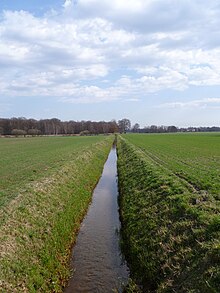
The sea basin at the biological station |
||
| Data | ||
| Water code | DE : 34454-0 | |
| location | North Rhine-Westphalia ; Germany | |
| River system | Ems | |
| Drain over | Speller Aa → Große Aa → Ems → North Sea | |
| source | Confluence of two unnamed trenches at Flüddert 52 ° 20 '1 " N , 7 ° 37' 11" O |
|
| Source height | 46 m above sea level NN | |
| muzzle | between Hopsten and Recke in the Hopstener Aa coordinates: 52 ° 21 '44 " N , 7 ° 39' 6" E 52 ° 21 '44 " N , 7 ° 39' 6" E |
|
| Mouth height | 45 m above sea level NN | |
| Height difference | 1 m | |
| Bottom slope | 0.19 ‰ | |
| length | 5.2 km | |
| Medium-sized cities | Ibbenbueren | |
| Communities | Recke, Hopsten | |
The Meerbecke is a stream that flows into the Hopstener Aa .
The sea Becke created west of the from the confluence of two unnamed ditches Uffelner settlement Flüddert. It flows past the Heiliges Meer - Heupen nature reserve and flows into the Hopstener Aa.
Water information
In order to keep low-lying fields and pastures dry, it was built as a drainage ditch in the 19th century. Until 1968 the water was discharged directly into the Great Sacred Sea , which, however, had a strong negative impact on the water quality of the lake. Due to the inclusion of a few small ditches and streams from the Uffelner Berg, the water for a stream in the Plantlünner sand plain has high hydrogen carbonate loads of up to 280 mg / l. The reasons given for this are the earlier lime mining and the former lime kilns in Uffeln and on the Dickenberg .
In 1968 the watercourse was relocated as part of the land consolidation, as the nutrients introduced impaired the function of the Great Sacred Sea as a nature reserve. Above all, the introduction of large amounts of iron hydroxide, which the sea basin carries with it, had a negative impact. Since then, the sea basin has also acted as a ring trench, which keeps nutrient-rich surface water away from the nature reserve core area.
Today's course is south of the Great Holy Sea, further east the sea basin takes up its old bed again. In the hay barn she takes on smaller drainage ditches and the sporadic drainage from the Great Holy Sea. From here, up to the confluence with the Hopstener Aa, it also represents the border between the municipalities of Hopsten and Recke . Based on the municipal boundaries between Hopsten and Recke, one can also see the relocated course of the Meerbecke.
The sea basin has water quality 2 over its entire length , the water structure quality is divided into percentages: 6% in class 3, 37% in 4, 15% in 5 and 42% in 6. Here, the change in the water becomes clear, especially after leaving the Protected area, the water almost resembles a road ditch with a trapezoidal cut in the arable land.
Individual evidence
- ^ German basic map 1: 5000
- ↑ Topographic map 1: 25,000
- ↑ Topographical Information Management, Cologne District Government, Department GEObasis NRW ( Notes )
- ↑ Archived copy ( memento of the original from January 20, 2016 in the Internet Archive ) Info: The archive link was inserted automatically and has not yet been checked. Please check the original and archive link according to the instructions and then remove this notice. Length and water quality
- ↑ DNB 964220113/34 hydrogen carbonate freight p. 56
- ↑ The Heiliges Meer nature reserve by Heinz-Otto Rehage, p. 7.
- ↑ http://www.tim-online.nrw.de/tim-online/initParams.do map waters / height coordinates
- ↑ Archived copy ( memento of the original from January 20, 2016 in the Internet Archive ) Info: The archive link was inserted automatically and has not yet been checked. Please check the original and archive link according to the instructions and then remove this notice. Change in the river bed and water quality

