
Meidlinger Hauptstrasse
| Meidlinger Hauptstrasse | |
|---|---|
|
|
|
 |
|
| Basic data | |
| place | Vienna |
| District | 12th district |
| Created | in the 18th century |
| Hist. Names | Main road |
| Cross streets | Schönbrunner Strasse, Hufelandgasse, Theresienbadgasse, Arndtstrasse, Niederhofstrasse, Füchselhofgasse, Tivoligasse, Reschgasse, Hilschergasse, Bonygasse, Krichbaumgasse, Pohlgasse, Zeleborgasse, Ratschkygasse, Sechtergasse, Eichenstrasse |
| Places | Meidlinger Platzl |
| use | |
| User groups | Pedestrians , bicycle traffic , car traffic , bus routes 10A 63A |
| Road design | Pedestrian zone |
| Technical specifications | |
| Street length | approx. 1015 m |
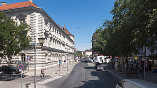
The Meidlinger Main Street is the main shopping street of the 12th Viennese community district, Meidling , and today largely pedestrianized.
Course and characteristics
Meidlinger Hauptstrasse runs in a central location between Meidling
- the Lobkowitzbrücke over the Wien River , the underground station Meidling Hauptstraße (U4) and the Schönbrunner Straße in the north and
- the higher Philadelphiabrücke over the Südbahn with the station Wien Meidling (the southern end point of the S-Bahn main line ) in the Eichenstraße and the so called Philadelphiabrücke underground station (U6) in the south until 2013 .
The approximately 1 km long road leads, apart from a small bend at Meidlinger Platzl in the northernmost section (where Arndtstrasse and Niederhofstrasse converge [with bus lines 10A and 63A], both coming from the east), in a straight line uphill towards the Wienerberg . There is a pedestrian zone from Meidlinger Platzl to the south . Business premises dominate the ground floors of the houses along the entire course of the street.
In public transport, the street is mainly served by the above-mentioned underground stations at both ends, which are also served by several bus lines. The Philadelphiabrücke is also a stop for tram line 62 and the local train between Vienna and Baden .
Drivers can use the main street in one-way traffic from Eichenstrasse north to Sechtergasse and from Niederhofstrasse northwards to Schönbrunner Strasse (10A, 63A) (access loops). The pedestrian zone was extended from Meidlinger Platzl northwest through Theresienbadgasse to Hufelandgasse. From 2014 to 2017 the pedestrian zone was renewed, the surface covering was redesigned, benches were set up and trees were planted. Slender columns of light increase the feeling of security, and the removal of steps at the Meidlinger Platzl has made the zone largely barrier-free. Meidlinger Hauptstraße is crossed by the streets Tivoligasse / Reschgasse, Bonygasse and Pohlgasse / Rauchgasse (bus route 9A); further alleys open on both sides offset.
Apart from a few Wilhelminian-style buildings from around 1900 and a few single-storey houses from the 19th century, the building consists mainly of residential and commercial buildings that were built after 1945.

The northern end at Schönbrunner Strasse
At Hufelandgasse

At Meidlinger Platzl

At Bonygasse

At No. 51

At No. 65

The southern end at Eichenstrasse


history
Meidlinger Hauptstrasse runs in the central area of the former Viennese suburb of Untermeidling . Both church and school were in their catchment area in the 18th century. After the incorporation into the city of Vienna, which came into force in 1892, the street quickly developed into the main shopping street. In 1905 the name Hauptstraße was officially supplemented by the location Meidlinger , since in 1892 numerous main streets were incorporated and there was a risk of confusion. Where today there is a free space (the Meidlinger Platzl) was located until 1936, protruding from the west in front of today's building line, the so-called Paterhaus. It was demolished as a "traffic obstruction".
The main street has been used by a horse tramway since 1884, which ran from Mariahilfer Gürtel in the north to Eichenstraße in the south, where a steam tramway to Wiener Neudorf , the forerunner of the Vienna – Baden local railway , had been running since 1886 . In 1903 the route through the main road was electrified, the route did not change. When alphanumeric line signals were introduced in 1907, it was Line 8 that drove through Meidlinger Hauptstrasse - until 1989, and most recently through the pedestrian zone. The 8er was discontinued in 1989 due to the extension of the U6 to the Philadelphiabrücke. The pedestrian zone was then completed by 1994 and the Meidlinger Platzl was designed by Boris Podrecca .
At the northern end of the street, the Vienna Steam Light Rail has been operating since 1898 , which became the Vienna Electric Light Rail in 1925 and was finally incorporated into the Vienna U-Bahn in the early 1980s . The southern line has been running at the southern end of the street since 1841. The number 62 to Lainz , Wolkersbergenstrasse has been running across the Philadelphiabrücke since 1907, electrically since 1910 .

Former rectory of the Meidlinger Church, No. 10

oldest school in Meidling (1753-1862), no.17

Füchselhof, No. 26

former Paterhaus (1907), No. 14-16

Picture postcard from 1903

Tram line 8 (1977)

Tram line 9 (1978)


Remarkable structures
(The numbering starts at the north end of the street. Even-numbered houses are on the west, odd-numbered houses on the east.)
No. 2: Municipal District Office

With the main entrance at Schönbrunner Straße 259, the corner building is a municipal office building built before 1914, in which the district council , the district council and the municipal district office for the 12th district are housed as a branch of the magistrate.

No. 3: Votive column
There is a baroque votive column in front of house number 3. A square base supports a round column on which a square with two reliefs is placed. One shows the conversion of the Apostle Paul and bears the year 1687, the other relief shows a mercy seat and dates from 1756.
No. 5: Müller-Fembeck-Hof
In the place of the owner-occupied house from 1965, there was once the community inn, Zum golden Lamm . In the hall there is a memorial plaque with a portrait relief for Josef Müller-Fembeck (1881–1961). He founded the Meidlinger Workers' Association and was a co-initiator of the People's Welfare Association. The Christian-Social was a city council from 1917 to 1920 and a local council from 1914 to 1934.
No. 8–10: August-Fürst-Hof
The large residential complex of the City of Vienna with the additional address Theresienbadgasse 7–9 was built in 1955–1957. On the corner risalit of Meidlinger Platzl there are majolica pictures by Leopold Schmid, which show (from top to bottom) the coats of arms of the former local communities, which or parts of which were combined in 1892 to form the 12th district: Obermeidling (left, 1st and 2nd from above ; the 2nd symbolizes the Grünberg ), Untermeidling (right, 1st and 2nd from above), Gaudenzdorf (left, 3rd from above), Hetzendorf and Altmannsdorf (right, 3rd from above), Hundsturm and Neumargareten (left , below). In the courtyard of the complex there is a bronze sculpture by Rudolf Schwaiger from 1955 depicting a seated girl.
The facility was named in 1982 after the Meidlinger district chairman August Fürst (1892–1974), who held his office from 1945 to 1959 and made great contributions to the reconstruction of the district, which was badly damaged by the war.
Meidlinger Platzl

Coat of arms house

Coat of arms of Obermeidling (1955) by Leopold Schmid

The Meidling Baths (1955) by Leopold Schmid

Grünberg (1955) by Leopold Schmid
Untermeidling (1955) by Leopold Schmid

Gaudenzdorf (1955) by Leopold Schmid
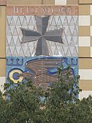
Hetzendorf (1955) by Leopold Schmid

Neumargareten (1955) by Leopold Schmid

Sitting girl (1955) by Rudolf Schwaiger

at Theresienbadgasse


No. 12–14: Ceramic mosaic
On this building there is a ceramic mosaic Abstract field division by Rothraut Brauneis from 1956.
No. 16-18: Ernst Epstein

The house was built by Ernst Epstein in 1935 after the previous building, which "protruded far into the street," had been demolished.
No. 17: Former school location
In place of house number 17 there was the first school building in Meidling. It was built in 1753 and served until 1862.
No. 19: Futterweit commemorative plaque
A memorial plaque for Norbert Futterweit was installed here in 2008 . On June 12, 1933, the Jewish jeweler and a passer-by were victims of a National Socialist bomb attack on their shop in this house.
No. 26: Füchselhof
This is where the small, low Füchselhof was located until 1903, the garden of which extended to Ruckergasse . It was mentioned as early as 1442 when the widow Füchsel bought it from Ulrich Eybesbrunner. (The Füchsel family also owned the Füchselhof next to St. Stephen's Cathedral, which was demolished in 1841. ) The Füchselhofgasse leading from the main street to Ruckergasse and named in 1902 also reminds of the courtyard. The Füchselhofkino at No. 20 also bore this traditional name.
No. 79: Mosaic Pictures

The southernmost building on the eastern side of Meidlinger Hauptstrasse, on the corner of Wilhelmstrasse 70, has four mosaic pictures showing a fir tree, a motorway with a viaduct, a girl lying down and an apple harvest. You can also see the Philadelphia locomotive , after which the bridge over the southern runway is named.
retail trade
In the “central retail area” of Meidling, which is mainly formed by Meidlinger Hauptstrasse, less retail space has been used since 1970 than before. The supply has declined, especially for home furnishings and clothing. The vacant share of retail space is low at 4.5% and has also decreased somewhat since 2004 (5.5%).
The opening of the "Arcade Meidling" shopping center, located at the southern end of Meidlinger Hauptstrasse at the corner of Eichenstrasse (immediately after the 2004 analysis was completed), initiated a clear upward trend. The retail space increased by 17.4% to 42,600 m² and the retail space by 14.7% to 32,000 m². The development of customer frequency and turnover is better than the average of all business streets in Vienna, to which the good connection of the street to the public transport (U-Bahn, S-Bahn, Südbahn, tram and bus lines) contributes.
literature
- Wolfgang Mayer: District culture guide Meidling . Youth & People: Vienna 1984, ISBN 3-224-10613-1 .
- Felix Czeike (Ed.): Ruckergasse. In: Historisches Lexikon Wien . Volume 4, Kremayr & Scheriau, Vienna 1995, ISBN 3-218-00546-9 , p. 232 ( digitized version ).
- Location + Market: S + M Documentation Business Streets Vienna 2009 , Baden 2010
- Walter Krobot, Josef Otto Slezak, Hans Sternhart: Tram in Vienna - the day before yesterday and the day after tomorrow , Verlag Josef Otto Slezak, Vienna 1972, ISBN 3-900134-00-6
- Helmut Portele: "Wiener Tramwaymuseum" collection, self-published by the Wiener Tramwaymuseum collection, Vienna ³2009, ISBN 978-3-200-01562-3
Web links
Individual evidence
- ↑ http://www.strassenbahnjournal.at/sjneu/content.php?section=87
- ↑ http://www.fahrgast.at/z99-3-2.htm
- ^ Friedrich Achleitner : Austrian architecture in the 20th century. A guide in four volumes , Volume III / 1, Vienna, 1. – 12. District, Residenz Verlag, Salzburg and Vienna 1990, ISBN 3-7017-0635-2 , p. 315
- ↑ Memorial plaque for Norbert Futterweit ( Memento from August 15, 2011 in the Internet Archive )
- ↑ Location + Markt S + M Documentation Vienna Business Streets 2009
Coordinates: 48 ° 10 ′ 44 ″ N , 16 ° 19 ′ 48 ″ E