Meienreuss
| Meienreuss | ||
|
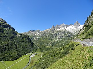
The Meienreuss in the Meiental with a view towards the Susten Pass |
||
| Data | ||
| Water code | CH : 714 | |
| location | Canton of Uri ; Switzerland | |
| River system | Rhine | |
| Drain over | Reuss → Aare → Rhine → North Sea | |
| source | at Tschingelfirn near the Susten Pass on the border with the canton of Bern 46 ° 43 ′ 6 ″ N , 8 ° 28 ′ 24 ″ E |
|
| Source height | approx. 2708 m above sea level M. | |
| muzzle | at Wassen in the Reuss coordinates: 46 ° 42 '34 " N , 8 ° 36' 17" E ; CH1903: 689 176 / 173 802 46 ° 42 '34 " N , 8 ° 36' 17" O |
|
| Mouth height | approx. 821 m above sea level M. | |
| Height difference | approx. 1887 m | |
| Bottom slope | approx. 13% | |
| length | 14.3 km | |
| Catchment area | 71.5 km² | |
| Discharge at the A Eo estuary gauge : 71.5 km²
|
MQ Mq |
4.09 m³ / s 57.2 l / (s km²) |
| Left tributaries | Sustlibach, Gorezmettlenbach, Seebach | |
| Right tributaries | Griessenbach, Schwarzbach, Kartigelbach | |
| Communities | Water | |
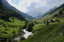
The Meienreuss is a 14.3 kilometer long left tributary of the Reuss , which flows through the Meiental in the municipal area of Wassen in the southwest of the canton of Uri . It drains an area of 71.5 km².
course
The Meienreuss originated 200 years ago on the wide Chalchtalfirn east of the Vorderen Sustenhorn . Since this firn has withdrawn a long way, the Meienreuss still has two sources on the withdrawn Chalchtal and on the remainder of the east, the Tschingelfirn . Between these, the Sustenjoch leads to the southern side of the mountain range. The Meienreuss first flows in a north to north-westerly direction before turning south-east after about 2.5 kilometers on the Guferalp. It now passes the hamlets of Färnigen and Meien and finally flows into the Reuss from the left at Wassen .
Individual evidence
- ↑ a b c Geoserver of the Swiss Federal Administration ( information )
- ↑ Length ( Memento of the original from August 19, 2014 in the Internet Archive ) Info: The archive link was inserted automatically and has not yet been checked. Please check the original and archive link according to the instructions and then remove this notice. Hydrological Atlas of Switzerland
- ↑ Modeled mean annual discharge. In: Topographical catchment areas of Swiss waters: area outlets. Retrieved August 14, 2016 .

