Michelbach (Usingen)
|
Michelbach
City of Usingen
|
|
|---|---|
| Coordinates: 50 ° 22 ′ 21 ″ N , 8 ° 31 ′ 59 ″ E | |
| Height : | 388 m above sea level NN |
| Residents : | 310 (June 30, 2011) |
| Incorporation : | December 31, 1971 |
| Postal code : | 61250 |
| Area code : | 06081 |
|
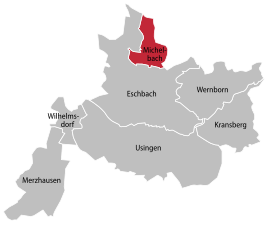
Location of Michelbach in Usingen
|
|
Michelbach is a district of Usingen in the Hochtaunuskreis in Hesse .
geography
Michelbach is located in the eastern Hintertaunus of the Taunus Nature Park at an altitude of 300 to 500 meters above sea level . The highest elevation in the district is at a height of 495 m above sea level. NN . The village is surrounded by mixed forests in a valley basin. The stream of the same name runs through the village, which rises in the higher elevations.
Neighboring towns are Hundstadt (west), Bodenrod (northeast), Maibach (east), Wernborn (southeast) and Eschbach (south).
history
Michelbach on the northernmost edge of the Usinger Basin is - like Eschbach - mentioned for the first time in 1280. It was probably devastated in the 15th century or the Thirty Years War . In 1716 the place was founded with twelve settling families.
In terms of church, the former village still belongs to Eschbach and, like the latter, had a share in the Hundstadter Waldmark, but had its own hunter's farm. The former elementary school now serves as a village community center. In 1933 the place had 145 inhabitants.
As part of the regional reform in Hesse , the community of Michelbach was incorporated into Usingen on December 31, 1971 on a voluntary basis.
Infrastructure
The old school is in the center of the village. This was built in 1905 and offered space for a class and a teacher's apartment. Today the children go to the chaffinch school in Eschbach and the old school is used as a village community center. For this purpose, an extension was built on the left side. Behind the old school is the bakery , built in 1825 . It is still used today for this purpose on special occasions. The ensemble is rounded off by the fire station of the volunteer fire brigade .
Web links
- Michelbach district ( Memento from February 12, 2013 in the web archive archive.today ) In: Internet presence of the city of Usingen.
- Michelbach, Hochtaunuskreis. Historical local dictionary for Hessen. In: Landesgeschichtliches Informationssystem Hessen (LAGIS).
Individual evidence
- ↑ Registration office statistics. (PDF) City of Usingen, archived from the original on February 20, 2014 ; accessed in August 2018 .
- ↑ Mean height of Michelbach: TK Kompass - Eastern Taunus 840 - 1: 50,000
- ^ Christian Daniel Vogel: Historical topography of the Duchy of Nassau . Werborn 1836, p. 277 .
- ↑ Statistics of the German Empire. Volume 451: Population, occupation and company census of June 16, 1933. Issue 3: The population of the German Reich according to religious affiliation. Berlin 1936.
- ↑ Gerstenmeier, K.-H. (1977): Hessen. Municipalities and counties after the regional reform. A documentation. Melsungen. P. 274


