
Dog city
|
Dog city
community Grävenwiesbach
|
|
|---|---|
 |
|
| Height : | 341 m above sea level NHN |
| Area : | 8.25 km² |
| Residents : | 879 (December 31, 2015) |
| Population density : | 107 inhabitants / km² |
| Incorporation : | December 31, 1971 |
| Postal code : | 61279 |
| Area code : | 06086 |

Hundstadt is a district of Grävenwiesbach in the Hessian Hochtaunuskreis .
geography
Hundstadt is located in the eastern Hintertaunus in the Taunus Nature Park . The village is about 2.5 kilometers southeast of Grävenwiesbach. The highest point near Hundstadt is the quartzite rock of the Hirschsteinlai at 430 meters above sea level .
Neighboring towns are Laubach (southwest), Naunstadt (west), Michelbach (east) and Wilhelmsdorf (south).
Hundstadt is the second largest district of the municipality of Grävenwiesbach with almost 900 inhabitants.
history
The location of Hundstadt - together with the districts of Mönstadt and Naunstadt, results in a semicircle around Grävenwiesbach - suggests that it is a planned expansion site starting from Grävenwiesbach. From the name one can conclude that the place was built between the 11th and 14th centuries. The foundation of the "statt-Orte" can be assigned to this time.
Hundstadt was first mentioned in a document as "Hoenstad" in 1410. In 1568 there were most horses in the parish in Hundstadt, which suggests that a haulage company was active. This is also supported by the fact that the road from Limburg ad Lahn to Wetterau passed the place at that time.
In the course of the territorial reform in Hesse , the communities Hundstadt and Grävenwiesbach and other communities voluntarily merged to form the community of Grävenwiesbach on December 31, 1971.
coat of arms
Description : "A six-pointed silver star in blue."
The star appears in the seals of the village in 1816/1817 and was in all later seals. The meaning of the star is unknown. The coat of arms was approved and its colors determined in January 1953.
Attractions
Hirschstein rock
Not far from the village lies the Hirschsteinfelsen in the forest, formerly also called Hirschsteinsley, a quartzite rock that has been reduced in size by centuries of mining of building material. In earlier times the rock is said to have been twice as high and served as a quarry for the Usingen castle and road construction.
Fountain
Hundstadt has five cast iron wells . The oldest of these fountains is located at Hauptstrasse 24. The fountain from 1871 is built on the long side from two panels that are decorated with lions' heads. The one-piece sides have an empty circular ring. At the corner of Hauptstrasse and Weilerweg there is a fountain from 1893. Like the fountains in Hauptstrasse and Naunstädter Weg from the same year, it is decorated with acanthus rosettes .
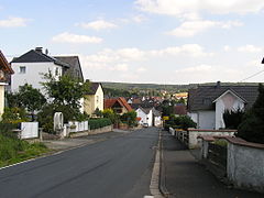
Street view of Hundstadt
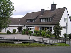
DGH Hundstadt

Old town hall Hundstadt
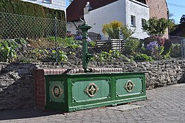
Brunnen Hauptstrasse / Weilerweg


Economy and Infrastructure
Location description
The appearance of the Hundstadt district is characterized by the long main street, which is closed off by two open-plan residential areas on the western and eastern outskirts. The old town center is centrally located, with partially closed construction and mixed use. The eastern residential area (Feldbergstrasse / Auf den Gräben) is followed by a small commercial area with four companies and the sports field.
traffic
Two traffic routes run through the Hundstadt district parallel to the elongated locality. The federal road 456 in the north and the state road 3063 in the south belong to the main traffic arteries in the northern Hintertaunus. They connect the Limburg-Weilburg district and the Lahn-Dill district with the Usinger Basin, the Vordertaunus and thus with the city of Frankfurt. Hundstadt also has a train station on the Taunusbahn , which connects Hundstadt by train to Grävenwiesbach or Waldsolms and Bad Homburg or Frankfurt.
Web links
- The history of the Hundstadt district on the website of the municipality of Grävenwiesbach.
- Local history on the website of the Heimat- und Geschichtsverein Grävenwiesbach e. V.
- Hundstadt, Hochtaunuskreis. Historical local dictionary for Hessen. (As of December 10, 2014). In: Landesgeschichtliches Informationssystem Hessen (LAGIS).
- Literature about Hundstadt in the Hessian Bibliography
Individual evidence
- ↑ Areas on the website of the municipality of Grävenwiesbach , accessed in July 2016.
- ↑ Population statistics on the website of the municipality of Grävenwiesbach , accessed in July 2016.
- ↑ Gerstenmeier, K.-H. (1977): Hessen. Municipalities and counties after the regional reform. A documentation. Melsungen. P. 266
- ^ Hundstadt - coat of arms of Hundstadt. In: www.ngw.nl. Retrieved October 28, 2016 .
- ↑ Karl Baeumerth: Cast iron fountain in Usingen country; in: Hochtaunus Yearbook 1993, ISSN 0943-2108 , pp. 44-45

Grävenwiesbach | Heinzenberg | Hundstadt | Laubach | Mönstadt | Naunstadt