| Serial No.
|
Distance to Boston [ mi ]
|
image
|
Built
|
Coordinates
|
place
|
Web link
|
Remarks
|
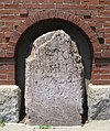
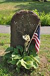
| 1
|
1
|

|
1744
|
Roxbury / Center Street
42 ° 19 ′ 48.2 " N , 71 ° 5 ′ 30.4" W.42.330054 -71.091775
|
Boston
|
MACRIS database entry
|
Known as Parting Stone or Parting Ways Stone .
|
| 2
|
4th
|
|
1729
|
841 Huntington Avenue
42 ° 19 ′ 58.6 " N , 71 ° 6 ′ 38.4" W.42.33294 -71.110663
|
Boston
|
MACRIS database entry
|
|
| 3
|
5
|

|
1729
|
210 Harvard Street
42 ° 20 ′ 25.2 ″ N , 71 ° 7 ′ 15 ″ W.42.340335 -71.120841
|
Brookline
|
MACRIS database entry
|
|
| 4th
|
6th
|

|
1729
|
142 Harvard Avenue
42 ° 21 ′ 6.2 " N , 71 ° 7 ′ 54" W.42.351712 -71.131657
|
Boston
|
MACRIS database entry
|
|
| 5
|
7th
|

|
1729
|
240 North Harvard Street
42 ° 21 '41.7 " N , 71 ° 7' 48.5" W.42.361594 -71.130135
|
Boston
|
MACRIS database entry
|
|
| 6th
|
8th
|
|
1734
|
Garden St. Burying Ground
42 ° 22 ′ 30.3 ″ N , 71 ° 7 ′ 9.5 ″ W.42.375077 -71.119303
|
Cambridge
|
MACRIS database entry
|
|
| 7th
|
23
|

|
1767
|
River and Water Row Road
42 ° 22 ′ 19 ″ N , 71 ° 23 ′ 7.4 ″ W.42.371939 -71.385402
|
Wayland
|
MACRIS database entry
|
|
| 8th
|
24
|

|
1767
|
MA 20 & Landham Road
42 ° 21 ′ 39.8 " N , 71 ° 24 ′ 6.7" W.42.361057 -71.401867
|
Sudbury
|
MACRIS database entry
|
|
| 9
|
25th
|

|
1767
|
MA 20 & Concord Road
42 ° 21 ′ 44.1 ″ N , 71 ° 24 ′ 58.2 ″ W.42.362247 -71.41617
|
Sudbury
|
MACRIS database entry
|
|
| 10
|
26th
|

|
1767
|
MA 20 & Nobscot Road
42 ° 21 ′ 36.4 ″ N , 71 ° 25 ′ 29.9 ″ W.42.360109 -71.424979
|
Sudbury
|
MACRIS database entry
|
|
| 11
|
27
|
|
1767
|
MA 20 & Dudley Road
42 ° 21 ′ 36.4 " N , 71 ° 26 ′ 13.2" W.42.36012 -71.437011
|
Sudbury
|
MACRIS database entry
|
Is missing
|
| 12
|
28
|

|
1767
|
MA 20 & Peakham Road 42 ° 21 '35
.3 " N , 71 ° 27' 30.3" W.42.359808 -71.458415
|
Sudbury
|
MACRIS database entry
|
|
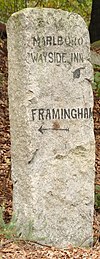
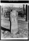
| 13
|
29
|

|
1767
|
Wayside Inn Road
42 ° 21 ′ 28.7 " N , 71 ° 28 ′ 16.6" W.42.357972 -71.471268
|
Sudbury
|
MACRIS database entry
|
|
| 14th
|
33
|

|
1767
|
148 East Main Street
42 ° 19 ′ 44.8 " N , 71 ° 37 ′ 20.6" W.42.329113 -71.622375
|
Northborough
|
MACRIS database entry
|
|
| 15th
|
35
|

|
1767
|
Dean Park
42 ° 17 ′ 45.4 " N , 71 ° 41 ′ 48" W.42.295936 -71.696664
|
Shrewsbury
|
MACRIS database entry
|
|
| 16
|
43
|

|
1767
|
West Main Street & Interstate 90
42 ° 17 ′ 39.3 ″ N , 71 ° 45 ′ 0.1 ″ W.42.294254 -71.750019
|
Shrewsbury
|
MACRIS database entry
|
|
| 17th
|
47
|

|
1767
|
Lincoln Street
42 ° 16 ′ 41.2 " N , 71 ° 47 ′ 39.9" W.42.278119 -71.794415
|
Worcester
|
MACRIS database entry
|
|
| 18th
|
48
|
|
1767
|
30 Elm Street
42 ° 15 ′ 53.9 " N , 71 ° 48 ′ 16.3" W.42.264959 -71.804535
|
Worcester
|
MACRIS database entry
|
Until 1987 the marker was located at 139 Salisbury Street
|
| 19th
|
53
|

|
1767
|
514 Main Street
42 ° 14 ′ 24 ″ N , 71 ° 53 ′ 7 ″ W.42.239987 -71.885266
|
Leicester
|
MACRIS database entry
|
Originally MA 9 & Colliers Corner
|
| 20th
|
54
|

|
1767
|
City Library
42 ° 14 ′ 45.5 ″ N , 71 ° 54 ′ 44 ″ W.42.24598 -71.91221
|
Leicester
|
MACRIS database entry
|
Originally 101 Pleasant Street; Moved to the city library in 1996
|
| 21st
|
56
|

|
1767
|
MA 9
42 ° 15 ′ 1.2 ″ N , 71 ° 56 ′ 34.6 ″ W.42.250346 -71.942951
|
Leicester
|
MACRIS database entry
|
Badly weathered condition
|
| 22nd
|
57
|

|
1767
|
MA 9
42 ° 15 '20.9 " N , 71 ° 57' 27.6" W.42.255808 -71.957658
|
Spencer
|
MACRIS database entry
|
|
| 23
|
58
|

|
1767
|
325 Main Street
42 ° 15 ′ 7.5 ″ N , 71 ° 58 ′ 32.9 ″ W.42.252078 -71.975794
|
Spencer
|
MACRIS database entry
|
|
| 24
|
59
|

|
1767
|
Main Street
42 ° 14 ′ 38.3 " N , 71 ° 59 ′ 37.5" W.42.24398 -71.99376
|
Spencer
|
MACRIS database entry
|
|
| 25th
|
60
|
|
1767
|
Dewey Street
42 ° 14 ′ 7.1 " N , 72 ° 0 ′ 32.3" W.42.23531 -72.00897
|
Spencer
|
MACRIS database entry
|
Moved to the current location after 1970
|
| 26th
|
61
|
|
1767
|
133 West Main Street
42 ° 13 '53.3 " N , 72 ° 1' 35.3" W.42.23147 -72.02646
|
Spencer
|
MACRIS database entry
|
|
| 27
|
62
|

|
1767
|
324 East Main Street
42 ° 13 ′ 37.4 " N , 72 ° 2 ′ 43.6" W.42.22706 -72.04544
|
East Brookfield
|
MACRIS database entry
|
Re-engraved after 1970
|
| 28
|
63
|

|
1767
|
184 North Brookfield Road
42 ° 13 '40.3 " N , 72 ° 3' 46.4" W.42.22787 -72.062901
|
East Brookfield
|
MACRIS database entry
|
|
| 29
|
64
|

|
circa 1752
|
Elm Hill Road
42 ° 13 ′ 51.2 " N , 72 ° 4 ′ 43.9" W.42.2309 -72.07886
|
Brookfield
|
MACRIS database entry
|
|
| 30th
|
65
|

|
circa 1752
|
Elm Hill Road
42 ° 13 ′ 19.6 " N , 72 ° 5 ′ 36.1" W.42.22211 -72.09337
|
Brookfield
|
MACRIS database entry
|
|
| 31
|
66
|
|
1767
|
31 West Main Street
42 ° 12 ′ 59.7 " N , 72 ° 6 ′ 36.4" W.42.216572 -72.110111
|
Brookfield
|
MACRIS database entry
|
|
| 32
|
67
|

|
circa 1765
|
102 Foster Hill Road
42 ° 13 ′ 39 ″ N , 72 ° 7 ′ 13.8 ″ W.42.227502 -72.120488
|
West Brookfield
|
MACRIS database entry
|
The stone was of Benjamin Franklin designed
|
| 33
|
68
|

|
1753
|
Eastern city limits
42 ° 14 ′ 10.2 ″ N , 72 ° 8 ′ 13.2 ″ W42.236168 -72.137009
|
West Brookfield
|
MACRIS database entry
|
The stone was of Benjamin Franklin designed
|
| 34
|
69
|

|
circa 1765
|
147 West Main Street
42 ° 14 '2.7 " N , 72 ° 9" 23.4 " W.42.23407 -72.15649
|
West Brookfield
|
MACRIS database entry
|
The stone was of Benjamin Franklin designed
|
| 35
|
70
|

|
1753
|
Main Street
42 ° 13 ′ 22.1 ″ N , 72 ° 10 ′ 17.9 ″ W.42.222811 -72.171627
|
Warren
|
MACRIS database entry
|
|
| 36
|
71
|

|
1753
|
Burbank & Washington Street
42 ° 12 '46.6 " N , 72 ° 10' 57.6" W.42.212956 -72.182658
|
Warren
|
MACRIS database entry
|
|
| 37
|
72
|

|
1753
|
25 Winthrop Terrace
42 ° 12 ′ 48.1 ″ N , 72 ° 11 ′ 31.2 ″ W.42.21336 -72.192009
|
Warren
|
MACRIS database entry
|
Moved to the current location after 1970
|
| 38
|
73
|

|
1753
|
Baypath Road
42 ° 11 ′ 55.3 " N , 72 ° 12 ′ 15.2" W.42.198698 -72.204223
|
Warren
|
MACRIS database entry
|
|
| 39
|
74
|

|
1753
|
970 Reed Street
42 ° 11 ′ 19.3 ″ N , 72 ° 13 ′ 9.5 ″ W.42.188689 -72.219313
|
Warren
|
MACRIS database entry
|
|
| 40
|
99
|
|
1767
|
3rd floor of the Springfield Armory Museum
42 ° 6 ′ 26.1 ″ N , 72 ° 34 ′ 53.3 ″ W42.107253 -72.581481
|
Springfield
|
MACRIS database entry
|
Moved to its present location around 1980 as part of a parking lot extension
|


