Mishmar ha-Negev
| Mishmar ha-Negev | ||
|---|---|---|

|
||
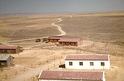
| Photo of the kibbutz from 1950 | ||
| Basic data | ||
| hebrew : | משמר הנגב | |
| State : |
|
|
| District : | south | |
| Founded : | October 6, 1946 | |
| Coordinates : | 31 ° 22 ' N , 34 ° 43' E | |
| Height : | 198 m | |
| Residents : | 933 (as of 2018) | |
| Community code : | 0395 | |
| Time zone : | UTC + 2 | |
| Community type: | Kibbutz | |
| Website : | ||
|
|
||
Mishmar ha-Negev ( Hebrew משמר הנגב; German: Guard post of the Negev) is a kibbutz on the northern edge of the Negev in Israel . It is on Road 264, about 2 km south of the Bedouin town of Rahat and about 10 miles northwest of Beer Sheva . The kibbutz is part of the B'nei Shimon regional administration . In 2009 the kibbutz consisted of 167 households with 560 inhabitants. Mischmar ha-Negev had 933 inhabitants in 2018.
The kibbutz was founded in 1946 as part of the Eleven Point Operation. The 30 founding members were members of the socialist, Zionist Borocho movement . Today the non-religious kibbutz is a member of the kibbutz movement .
Individual evidence
- ↑ אוכלוסייה ביישובים 2018 (population of the settlements 2018). (XLSX; 0.13 MB) Israel Central Bureau of Statistics , August 25, 2019, accessed May 11, 2020 .
