
Rhine Low Canal (Pfinz-Saalbach correction)
|
Rhine Low Canal Above the Pfinz |
||
 Confluence of the Pfinz (from left) into the Rhine Low Canal (through the weir) |
||
| Data | ||
| Water code | DE : 237694 | |
| location |
Upper Rhine Plain
|
|
| River system | Rhine | |
| Drain over | Pfinz → Rhine → North Sea | |
| source | in the rough value in the west of the Eggenstein district 49 ° 4 ′ 50 ″ N , 8 ° 21 ′ 19 ″ E |
|
| Source height | 99.5 m above sea level NN | |
| muzzle | in the Pfinz one kilometer west of Dettenheim-Rußheim 49 ° 11 '14 " N , 8 ° 24' 43" E |
|
| Mouth height | 96.5 m above sea level NN | |
| Height difference | 3 m | |
| Bottom slope | 0.18 ‰ | |
| length | 16.3 km | |
.jpg) Rheinniederungskanal between the Streitköpflesee (front left) and the Baggersee Mittelgrund (back right), in the background Leopoldshafen (photographer: Willy Pragher , 1973) |
||
|
Rhine low canal below the Pfinz |
||
 Rhine Low Canal near Philippsburg |
||
| Data | ||
| Water code | DE : 2377496 | |
| location |
Upper Rhine Plain
|
|
| River system | Rhine | |
| Drain over | Saalbach → Rhine → North Sea | |
| origin | Branch from the Pfinz in the Rußheimer Altrhein 49 ° 12 ′ 12 ″ N , 8 ° 25 ′ 40 ″ E |
|
| Source height | 96 m above sea level NN | |
| muzzle | in the Saalbach northeast of Philippsburg Coordinates: 49 ° 15 '8 " N , 8 ° 28' 14" E 49 ° 15 '8 " N , 8 ° 28' 14" E |
|
| Mouth height | 94.5 m above sea level NN | |
| Height difference | 1.5 m | |
| Bottom slope | 0.2 ‰ | |
| length | 7.6 km | |
The Rhine Low Canal is a drainage canal in the northwest of the Karlsruhe district between Eggenstein-Leopoldshafen and Philippsburg . It was created during the Pfinz-Saalbach correction (1934–1962) from the connection of existing drainage systems. The canal lies entirely in the Upper Rhine Plain in the natural area of the Northern Upper Rhine Lowlands , which is locally mostly referred to as the Tiefgestade .
Definitions of the course of water
According to the Water Act for Baden-Württemberg, the Lower Rhine Canal begins at the Hafendamm lock near Leopoldshafen ⊙ and ends at the confluence with the Rhine ⊙ . The Pfinz is regarded in the law as a tributary of the Rhine Low Canal. This definition is followed by the labeling in the topographic maps.
The determination of the course of the watercourse in the official digital water management network (AWGN) differs in three points:
- The southern part of the Rhine Lower Canal flows into the Pfinz near Dettenheim-Rußheim , which, according to the AWGN, drains into the Rhine via the Rußheimer Altrhein . As a result, there are two parts of the Rhine Low Canal in the AWGN with different waterway codes .
- The northern part of the canal branches off from the Pfinz in the area of the Rußheimer Altrhein and is defined as the tributary of the Saalbach , so that the mouth of this part of the canal in the Philippsburg Old Rhine is northeast of Philippsburg.
- One of the tributaries to the Hafendammschleuse is assigned to the southern part, so that the canal also includes waters with the local names Reblach Nord , Reblach , Eggensteiner Altrhein and Niederauwasser .
Course of water
The Rhine Lower Canal starts in the Niederauwasser, a short piece of an old Rhine arch that is bounded by Rheindamm XXX in both the north and south . The canal flows to the northeast and crosses under the Hafendamm, a connection between the Rheindamm XXX and the center of Leopoldshafen . On the outskirts of Leopoldshafen, the Bach Canal flows from the right.
North of Leopoldshafen, the Lower Rhine Canal swings into the Linkenheimer Altrhein (also called the Dead Rhine ) and flows in two opposite arcs around the quarry pond Mittelgrund on the left bank and the Streitköpflesee on the right bank. At the end of the Linkenheimer Altrhein the canal in the Dyckerhoff lock passes the Rheindamm XXIX , an inland dike that connects the main Rhine dam with the flood-free area of the Hardt Plains.
The canal runs parallel to the Rhine for almost a kilometer and at a distance of around 600 meters, passing the Rohrköpflesee , another quarry pond on the right bank . To the west of Linkenheim the canal moves away from the Rhine again, turns to the northeast and follows an old course of the Rhine. To the north of the Linkenheim airfield , the eastern Herrenwasser flows from the right , which continues in the opposite direction as the continuation of the old Rhine used by the Lower Rhine Canal.
Running north from the airfield, the Lower Rhine Canal crosses the predominantly agricultural area between Liedolsheim and the abandoned town of Alt-Dettenheim in two long straight lines . There are two more quarry ponds on the left bank, the Giessen lake and the Giessen quarry pond .
To the west of Russheim , the Pfinz flows into the Lower Rhine Canal from the right and south-east . Immediately afterwards the canal crosses in a culvert under the Saalbach Canal , bordered by the Rhine dams XXX and XXXI , the Saalbach flood relief canal . After the culvert, the canal initially runs parallel to the Rußheimer Altrhein and then joins it.
The continuation of the canal bears the local name Jägerschrittkanal ; it branches off at the Jägerschrittschleuse around 600 meters southeast of the submerged town of Knaudenheim from the Rußheimer Altrhein. From the hunter's step lock the Rhine low canal is lined with flood protection dams. After crossing under the Bundesstraße 35 , the Extended Pfinz Canal flows from the right at Huttenheim . Now heading north, the Rhine Lower Canal passes through a forest, then runs along the western edge of the urban area of Philippsburg , passes under the Bruhrain Railway and then flows into the Philippsburg Old Rhine.
The Philippsburger Altrhein, a meander running first to the east and then to the north , passes the eponymous city on its northern edge and then takes in the Saalbach coming from the right and south . The Philippsburg pumping station is located near Oberhausen and ensures the drainage of the Rhine lowlands when the Rhine floods. The Rhine island of Corsica is on the left below the pumping station . Above and below the island, the Old Rhine is connected to the quarry pond "Insel Korsika" (Krieger) , to which the polder Rheinschanzinsel is connected via its inlet and outlet structure. At Rhine kilometer 391.8 the Old Rhine and thus the Rhine Low Canal flows into the Rhine from the right and east.
The Rußheimer Altrhein lies entirely within the nature reserve Rußheimer Altrhein-Elisabethenwört . Several sections of the Rhine Lower Canal are part of the Rheinaue landscape protection area north of Karlsruhe : the section south of the Hafendammschleuse at Leopoldshafen, the Linkenheimer Altrhein between Leopoldshafen and the Dyckerhoff lock, a section south of the Neue Mittelgründsbrücke at Linkenheim and a section at Rußheim on the culvert under the Saalbach Canal.
Tributaries
,_bei_Eggenstein-Leopoldshafen.jpg)
The starting point of the Lower Rhine Canal, the Niederauwasser , is the continuation of the Eggensteiner Altrhein and is connected to it by a culvert that crosses under the Pfinz relief canal . The old Rhine, around 3.5 kilometers long, was created in 1817 when a meander broke through in the area of today's smugglers' sea. Niederau water and harrows Steiner Altrhein were of the silting threatened and were desilted between 2005 and 2009. The Old Rhine was connected to the Alb Canal and has since been fed with 0.1 to 0.3 cubic meters of Rhine water per second in order to reduce the nutrient content.
At Eggenstein the Reblach flows from the right into the Eggensteiner Altrhein , the common lower course of two drainage ditches, which are known as Reblach Nord and Reblach Süd . The trenches run in wider channels from old arms of the Rhine, which were designated as oxbow lakes in 1817 and were already diked back then.
The Bach Canal flows into the Lower Rhine Canal near Leopoldshafen. In the upper reaches, known as the Weißer Graben , the Bach Canal, together with several side ditches , drains the edge of the Rhine lowlands at the transition to the Hardtebenen natural area north of the Karlsruhe district of Neureut . The 6.7 km long body of water, including the upper course, flows through several bogs, which are mostly destroyed today: the Neureuter Moor , the Füllbruch between Neureut and Eggenstein and the Böse Allmendwiesen between Eggenstein and Leopoldshafen.
There is a cross connection to the Rhine west of Linkenheim via ditches that connect the old Rhine island of Rott to the Rhine low canal via the Mittelgründloch still water body of around one hectare . The connection to the former Metz double lock was initially provisionally restored in 2009 and now finally restored during the renovation of Rheindamm XXX . The aim was to create a biotope network between the Rhine system and the Altaue, with the Rhine Lower Canal, as a continuous receiving water, being assigned an important function in the context of biotope networking. In addition, nutrient-poor Rhine water should be channeled into the Mittelgründloch.
The eastern Herrenwasser flows into the Rhine low canal from the right at Linkenheim airfield. The 7.1 kilometer long body of water branches off from the Rhine Low Canal near Leopoldshafen and, like the Bach Canal, drains the edge of the Rhine Lowland. At the level of Linkenheim, the Altäckergraben, which is almost two kilometers long, provides a cross connection between the Eastern Herrenwasser and the Rhine low canal. At Hochstetten, the Beyngraben (Gradnausbruchgraben) , which is also just under two kilometers long, flows from the right into the Eastern Herrenwasser. It arises in the Gradnausbruch , a moor planted with alder and poplar north of Hochstetten.
At the level of Liedolsheim, the two-kilometer-long Erlenbuschgraben flows from the right , which drains the area west of the Liedolsheim town center. At about the same height, a nameless ditch flows from the left, which is an outflow of the Königsee in the nature reserve Altrhein-Königsee . Another, also nameless outflow of the Königsee flows further north into the Rhine Low Canal.
The most important tributary of the Rhine Lower Canal is the Pfinz , which joins from the right west of Rußheim. The approximately 54-kilometer-long river rises on the northern edge of the Black Forest , flows through the southern Kraichgau and enters the Upper Rhine Plain near Karlsruhe-Grötzingen .
.jpg)
In the area of the Rheininsel Elisabethenwörth and the Rußheimer Altrhein there are three cross connections between the Rhine system and the Rhine Low Canal: Just above the confluence of the Pfinz, a bridge branches off from the Rhine Low Canal to the Saalbach Canal, which is usually closed by the new dam lock . The Saalbach Canal flows into the Rhine via the Alter Minthesee quarry pond . The Rußheimer Altrhein branches off from the quarry pond , which is also normally closed by the Rußheimer Altrhein inlet sluice . The lower part of the Rußheimer Altrhein is connected to the Rhine via the Kurfürstenbauschleuse . The Kurfürstenbauschleuse is only closed when the Rhine water levels are high.
The Extended Pfinz Canal, which flows west of Huttenheim, drains large parts of the Graben Bay , part of the Rhine lowlands that lies between the villages of Graben-Neudorf , Liedolsheim, Rußheim and Huttenheim. In addition, the canal is the receiving waters of the Alte Bach .

South of Philippsburg, three bodies of water flow from the right with the Alte Pfinz , the Bruchgraben (also Gottesacker ) and an unnamed ditch, which drain the area between Philippsburg and its district of Huttenheim. The area was in the area around the fortress Philippsburg , which was razed around 1800, and could be artificially flooded to protect the fortress .
Just above the Philippsburg pumping station, the Saalbach flows from the right into the Philippsburger Altrhein. It arises in Bretten im Kraichgau as the confluence of two streams and enters the Upper Rhine Plain near Bruchsal .
history
In its current form, the Rhine Lower Canal was created during the Pfinz-Saalbach correction from the connection of existing drainage systems. The hydraulic engineering measures were intended to improve the drainage of the Rhine lowlands, which were characterized by pressurized water from the Rhine, the depth and the lack of receiving water . This particularly affected the edge of the Rhine lowlands at the transition to the Hardt plains. The aim was a safe agricultural use of the alluvial clay in the Rhine lowlands, which are regarded as valuable .
Originally the Rhine Lower Canal was supposed to lead to the mouth of the Wagbach . In 1955 this plan was abandoned; instead, the Philippsburg pumping station was built until 1962. It was equipped with four pumps, each of which can lift five cubic meters per second at a delivery height of 2.56 meters. The aim was to achieve a maximum inland water level of 6.0 meters at the Maxau gauge . The lower Rhine canal is dimensioned below the mouth of the extended Pfinz canal for a maximum discharge of 28 cubic meters per second.
In the Leopoldshafen area, the Rhine lowlands were drained before the construction of the canal via the Linkenheimer Altrhein, which became the Old Rhine in 1772. It flowed into the long hole of the Rhine by the Rhine . With the dike in 1883, the Reitstegschleuse in today's Rheindamm XXX was built . Around 1925 the Metz double lock with a pumping station was built, through which the Linkenheimer Altrhein drained into the Altrhein Insel Rott . For this purpose, the Wiesendeich lock was built in Rheindamm XXIX . Around 1950 the Wiesendeich lock was given up in favor of the Rhine Lower Canal and the Dyckerhoff lock .
The Niederauwasser was connected to the Linkenheimer Altrhein in 1882 at the latest. The dam, which limits the Niederauwasser to the north, was built before 1840. It surrounded the port of Leopoldshafen, which was the most important port in the region at the time, but quickly lost its importance as a result of silting up and competition from the newly built ports in Karlsruhe.
A second inlet to the Metz double lock was the receiving waters from waters west of Linkenheim. It was reactivated in 2009 for ecological reasons.
In the Liedolsheim / Rußheim area around 1840, drainage was still carried out through several winding ditches running northwards. Before 1866, a channel in the route of the present-day Rhine lowland canal was built, initially as Rhine Canal , and later as a culvert and Mr. water channel was called.
The section of the Rhine Lower Canal between the confluence of the Extended Pfinz Canal and the Philippsburger Altrhein was originally part of the Pfinz Canal , which was laid out in the Baroque period (end of the 16th century to around 1760/70). In 1838 it started in an area east of Rußheim and north of the Pfinz, mainly used as meadows. The Jägerschrittkanal was built during the Pfinz-Saalbach correction; the lower part of the Pfinz Canal was added to the Rhine Low Canal; the upper part today belongs to the extended Pfinzkanal .
Water quality
In 2004, the Lower Rhine Canal above the mouth of the Pfinz and below the Philippsburg pumping station was classified in water quality class II-III “critically polluted”. The section between the mouth of the Pfinz and the pumping station was assigned to water quality class II “moderately polluted”.
From the 1960s onwards, wastewater from the Karlsruhe Nuclear Research Center was directed into the Lower Rhine Canal via the Eggenstein-Leopoldshafen sewage treatment plant. 94 percent of the plutonium emitted with the wastewater is fixed in the sludge sediment of the Linkenheim Old Rhine. Since 2001 the wastewater from the sewage treatment plant has been discharged directly into the Rhine. According to information from the Baden-Württemberg Ministry of the Environment from 2009, the "dose exposure of the population [...] is negligibly low compared to the naturally existing radiation exposure", so that the Linkenheim Old Rhine does not need to be rehabilitated.
The sewage treatment plants in Dettenheim / Graben-Neudorf and Linkenheim-Hochstetten use the Rhine Low Canal and the Eastern Herrenwasser as receiving waters.
Fish stocks
According to the Huttenheim sport fishing association in 1926 , which is the leaseholder of the Lower Rhine Canal near Philippsburg, the main fish species are roach and bream , as is typical for slow-flowing waters . There are also eels , rudds , tench , gusters and chub as well as gudgeons and hazel . Perch , pike , asp and, for some years now, catfish are found as predatory fish . For the Linkenheimer Altrhein in 2009 bullhead , loach and bitterling were named.
Web links
- Map of the course of the Rhine Lower Canal on: State Institute for the Environment Baden-Württemberg (LUBW) ( information )
- Photos and information on the water network in the Hardt north of Karlsruhe
Individual evidence
LUBW
Official online waterway map with a suitable section and the layers used here: Course of the Rhine Lower Canal
General introduction without default settings and layers: State Institute for the Environment Baden-Württemberg (LUBW) ( notes )
- ↑ a b c d Heights determined from the digital terrain model of the online waterway map.
- ↑ a b Length according to the waterway network layer ( AWGN ) .
- ↑ Local names after the layer water names .
- ↑ Protected areas according to the relevant layers.
Further evidence
- ↑ a b Josef Schmithüsen : Geographical land survey: The natural space units on sheet 161 Karlsruhe. Federal Institute for Regional Studies, Bad Godesberg 1952. → Online map (PDF; 5.1 MB)
- ↑ Water Act for Baden-Württemberg (WG) of December 3, 2013, Annex 1: List of first-order waters .
- ↑ Water Act for Baden-Württemberg (WG) of December 3, 2013, Annex 3: List of second-order waters in the maintenance of the state .
- ↑ Klaus Kern: Selected LIFE measures between Rheinstetten and Philippsburg. In: State Institute for the Environment, Measurements and Nature Conservation Baden-Württemberg (Ed.): Lebendige Rheinauen. Nature, culture and LIFE in the northern Upper Rhine. (= Naturschutz-Spectrum, Themes. Volume 98) Regionalkultur, Ubstadt-Weiher 2010, ISBN 978-3-89735-615-3 , pp. 176–289, here pp. 207–211.
- ↑ For the designation of the Rhine dams, see the Water Act for Baden-Württemberg (WG) of December 3, 2013, Annex 5: List of main dams .
- ↑ a b c d Map of the course of the Rhine from Basel to Grossh. Hessian border. In: Max Honsell : The correction of the Upper Rhine: From the Swiss border below Basel to the Grossh. Hessian border below Mannheim; especially the Baden stake in the company. Braun, Karlsruhe 1885. ( Digital copy , PDF, 53.2 MB)
- ↑ Kern, LIFE measures , pp. 207–211, 214.
- ^ Konrad Raab: Moore and Anmoore in the Upper Rhine Plain. (= Materials on Soil Protection , Volume 6), published by the State Institute for Environmental Protection Baden-Württemberg, Karlsruhe 1997, ISBN 3-88251-253-9 , pp. 75-77, 80 f.
- ^ Kern, LIFE measures , p. 244 f.
- ↑ Raab, Moore and Anmoore , p. 72.
- ↑ The lock names at: Regional Council Karlsruhe (ed.): Retentionsraum Elisabethenwört (Rußheim). Final report of the preliminary investigations . Karlsruhe 1992, p. 33 (pdf, 17.3 MB).
- ↑ a b Michael Hassler: The "great morass": Philippsburg and the small Pfinz. In: Dieter Hassler (Ed.): Wässerwiesen: History, technology and ecology of the irrigated meadows in Kraichgau, Hardt and Bruhrain. Verlag Regionalkultur, Ubstadt-Weiher 1995, ISBN 3-929366-20-7 , p. 312.
- ↑ Gismar Eck: Pfinz-Saalbach-correction. In: Ministry of the Interior of Baden-Württemberg (Ed.): Water management in Baden-Württemberg. Water supply, sewage disposal, river engineering, dam construction, agricultural hydraulic engineering, administration, organization. Verwaltungs-Verlag, Munich 1969, pp. 153–156.
- ↑ Hans Schaal, Fritz Bürkle : From hydraulic and cultural engineering to water management in Baden-Württemberg. 200 years of water management in southwest Germany. State Institute for Environmental Protection, Karlsruhe 1993, ISBN 3-88251-197-4 , p. 46.
- ^ Reports of the Badische Neuesten Nachrichten on the website of the Friends of Home History, Heimathaus Zehntscheuer eV Linkenheim-Hochstetten (accessed on May 26, 2019).
- ↑ Topografisches Bureau Baden (ed.); W. Winckens (Red.): Topographic map of the Grand Duchy of Baden. According to the general land survey of the Grand Ducal Military Topographical Bureau. Sheet 16: Karlsruhe. Karlsruhe 1838 ( online ).
-
↑ Topografisches Bureau Baden (ed.); V. Mayer (Red.): Topographic map of the Grand Duchy of Baden. According to the general land survey of the Grand Ducal Military Topographical Bureau. Sheet 11: Philippsburg. Karlsruhe 1838 ( online );
Topografisches Bureau Baden (ed.); W. Winckens (Red.): Topographic map of the Grand Duchy of Baden. According to the general land survey of the Grand Ducal Military Topographical Bureau. Sheet 16: Karlsruhe. Karlsruhe 1838 ( online ). - ↑ See the district overview on a scale of 1: 10,000 for Linkenheim (1867), Hochstetten (1866) and Liedolsheim (1869) at the General State Archives in Karlsruhe .
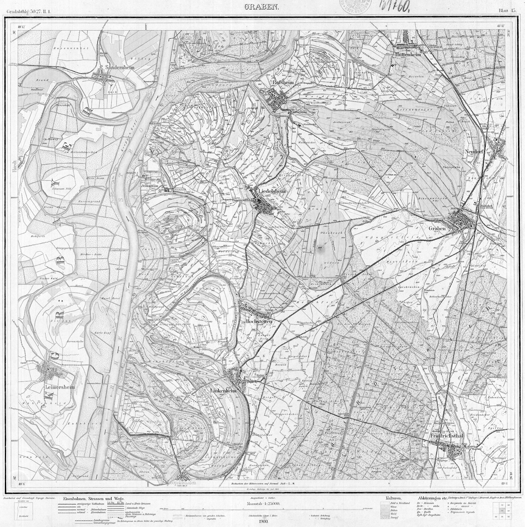
- ↑ Topografisches Bureau Baden (ed.): Meßtischblatt Nr. 45 Graben. Karlsruhe 1900 ( online ).
- ↑ Topografisches Bureau Baden (ed.); V. Mayer (Red.): Topographic map of the Grand Duchy of Baden. According to the general land survey of the Grand Ducal Military Topographical Bureau. Sheet 11: Philippsburg. Karlsruhe 1838 ( online ).
- ↑ State Institute for Environmental Protection Baden-Württemberg (edit.): Biological water quality of flowing waters in Baden-Württemberg. Processing status: 2004 (PDF, 11.7 MB)
- ↑ Redevelopment of the Linkenheimer Altrhein. Request of the deputy Dr. Gisela Splett et al. GREEN and statement from the Ministry of the Environment. State Parliament of Baden-Württemberg, printed matter 14/5120 of September 18, 2009 (PDF, 111 kB), pp. 5, 6 (quote).
- ↑ Leased waters on the website of the Sportfischervereinigung Huttenheim 1926 eV (accessed on June 6, 2017)
- ↑ Rehabilitation of the Linkenheimer Altrhein , Landtag printed matter 14/5120, p. 4.