
Extended Pfinz Canal
|
Extended Pfinzkanal section name sequence : Alte Bach → Galgengraben → Neugraben → Extended Pfinzkanal |
||
.jpg) Bridge on Landesstraße 602 Rußheim - Huttenheim over the extended Pfinz Canal |
||
| Data | ||
| Water code | DE : 23774962 | |
| location |
Upper Rhine Plain
|
|
| River system | Rhine | |
| Drain over | Rhine Low Canal → Saalbach → Rhine → North Sea | |
| source | at the latch bridge of the K 3579 over the Heglach near Stutensee- Friedrichstal 49 ° 5 ′ 49 ″ N , 8 ° 29 ′ 16 ″ E |
|
| Source height | approx. 112 m above sea level NHN | |
| muzzle | from the right and south-east into the Rhine low canal northwest of Philippsburg- Huttenheim next to the B 35 coordinates: 49 ° 12 ′ 22 ″ N , 8 ° 26 ′ 24 ″ E 49 ° 12 ′ 22 ″ N , 8 ° 26 ′ 24 ″ E |
|
| Mouth height | approx. 97 m above sea level NHN | |
| Height difference | approx. 15 m | |
| Bottom slope | approx. 1.1 ‰ | |
| length | 13.8 km | |
| Catchment area | 49,956 km² | |
 Close a ditch northeast of Rußheim with the high water mark of the Rhine flood in 1882/1883 |
||
The Extended Pfinz Canal is a drainage canal in the northwest of the Karlsruhe district . It drains large parts of the Graben Bay, which lies between the villages of Huttenheim (to Philippsburg ), Graben-Neudorf , Liedolsheim and Rußheim (both to Dettenheim ). In the official digital water management network (AWGN), other bodies of water are added to the extended Pfinzkanal, in particular the lower part of the Alte Bach . In topographic maps and in local parlance, these waters are not referred to as the extended Pfinzkanal.
History and course
The Northern Upper Rhine Lowlands are built up in the area of the Extended Pfinz Canal by a belt of complex interlocking deposits of the meandering Rhine . Several generations of meanders can be distinguished, which differ slightly in their altitude.
Hieronymus Nopp , Mayor of Philippsburg between 1877 and 1893 and author of a city history, sees the Kleine Pfinz (also Pfinzgraben ) as the forerunner of today's Extended Pfinz Canal . The construction of this completely artificial body of water was initiated in 1453 by the Speyer bishop Reinhard von Helmstatt . The Kleine Pfinz branched off east of Graben (today to Graben-Neudorf) and ran in a north-westerly direction to Udenheim (later renamed Philippsburg ). Udenheim was located on the Saalbach , but suffered from a chronic water shortage - also due to the numerous uses by the upstairs. The Pfinz was at the junction between the border river between the margraviate of Baden and the bishopric of Speyer . The water was initially divided in a ratio of one to one, from 1557 Baden received two thirds of the water. Johann Karl von Thüngen , in command of the Philippsburg Fortress , had another derivation from the Pfinz built just west of the branch in 1701, the Thüngen'sche Schließe . Large parts of the area around the fortress could be artificially flooded and turned into a morass. After the fortress was razed in 1799, the pipeline to Philippsburg was abandoned in the middle of the 19th century.
The Pfinzkanal was laid out during the baroque period (end of the 16th century to around 1760/70). In 1838 it started in an area east of Rußheim and north of the Pfinz which was mainly used as meadows . The Pfinz flows through the Graben Bay up to the two mills near Russheim in an elevated position; water was taken from her to irrigate the meadows . The Pfinzkanal, initially following a low meander, ran north and crossed a slightly higher part of the Rheinaue west of Huttenheim. Between Huttenheim and Philippsburg, the canal swung into an old course of the Rhine, which was a little lower, comparatively less curved, and flowed into the Rhine just above Philippsburg. In 1838 the correction of the Rhine was not yet completed; the average that made the Rhine at Philippsburg the Old Rhine had not yet taken up the valley path . Structures of the former Pfinz Canal are still in place today; for example, the Engel bridge is west of Huttenheim an arch bridge of sandstone which has been overbuilt with a concrete slab.
During the Pfinz-Saalbach correction (Pfisako) carried out between 1934 and 1962 , the Jägerschritt Canal was built as a connection between the Rußheimer Altrhein and the Pfinz Canal . The Jägerschritt Canal and the lower part of the Pfinz Canal are now part of the Rhine Lower Canal .
At the upper end, the Pfinzkanal was extended to the south. The extension also begins in a low-lying meander arch, for a short distance it penetrates a higher area and ends in a depression on both sides of the Pfinz. Today the Extended Pfinzkanal passes under the Pfinz and Saalbach channel in culverts or passages . The Saalbach Canal was built by Pfisako as a flood relief canal for the Saalbach ; in the Graben Bay it is bordered by high dams . The extended Pfinz Canal is also lined with dams below the junction with the Saalbach Canal.
As a result of the extension, the Pfinz Canal became the receiving water of the Galgengraben (also known as the Alte Bach), which was originally created to relieve the Pfinz-Heglach from flooding . The gallows ditch was later used to irrigate the meadows in what is now the Oberbruchwiesen nature reserve . At the same time, the catchment area of the Pfinzkanals expanded to include the southwestern part of the Graben Bay, which is predominantly part of the largest moor in the Upper Rhine Plain in Baden. In parts of the moor peat was mined until around 1900 , other parts such as the Oberbruchwiesen were used as irrigated meadows. Around 1900, this part of the Graben Bay was drained by the Scheidgraben, which initially ran west, then turned north and flowed south of Rußheim into the Pfinz.
Individual evidence
LUBW
Official online waterway map with a suitable section and the layers used here: Course and catchment area of the Extended Pfinz Canal
General introduction without default settings and layers: State Institute for the Environment Baden-Württemberg (LUBW) ( notes )
- ↑ a b Height according to the contour line image on the topographic map background layer .
- ↑ Length according to the waterway network layer ( AWGN ) .
- ↑ Catchment area according to the basic catchment area layer (AWGN) .
Other evidence
- ↑ Josef Schmithüsen : Geographical land survey: The natural space units on sheet 161 Karlsruhe. Federal Institute for Regional Studies, Bad Godesberg 1952. → Online map (PDF; 5.1 MB)
- ↑ a b c Elena Beckenbach: Geological interpretation of the high-resolution digital terrain model of Baden-Württemberg. University publication, University of Stuttgart 2016, p. 100 ( download) .
- ↑ Hieronymus Nopp: History of the city and former imperial fortress Philippsburg. From its emergence from the castle and the village of Udenheim to the onset of the same in Baden. Reprint of the 2nd edition (Speyer 1881), published in 1980 by the Philippsburg city administration, p. 503.
- ↑ Dieter Hassler: A thousand years of effort and no end. The history of brook construction in Kraichgau, Hardt and Bruhrain. In: Dieter Hassler (Ed.): Wässerwiesen: History, technology and ecology of the irrigated meadows, streams and ditches in Kraichgau, Hardt and Bruhrain. Verlag Regionalkultur, Ubstadt-Weiher 1995, ISBN 3-929366-20-7 , pp. 40–61, here pp. 53–55.
- ↑ Michael Hassler: The "great morass": Philippsburg and the small Pfinz. In: Dieter Hassler (Ed.): Wässerwiesen: History, technology and ecology of the irrigated meadows in Kraichgau, Hardt and Bruhrain. Verlag Regionalkultur, Ubstadt-Weiher 1995, ISBN 3-929366-20-7 , p. 312.
- ↑ Topografisches Bureau Baden (ed.); V. Mayer (Red.): Topographic map of the Grand Duchy of Baden. According to the general land survey of the Grand Ducal Military Topographical Bureau. Sheet 11: Philippsburg. Karlsruhe 1838 ( online ).
- ^ Konrad Raab: Moore and Anmoore in the Upper Rhine Plain. (= Materials on Soil Protection , Volume 6), published by the State Institute for Environmental Protection Baden-Württemberg, Karlsruhe 1997, ISBN 3-88251-253-9 , pp. 65-71.)
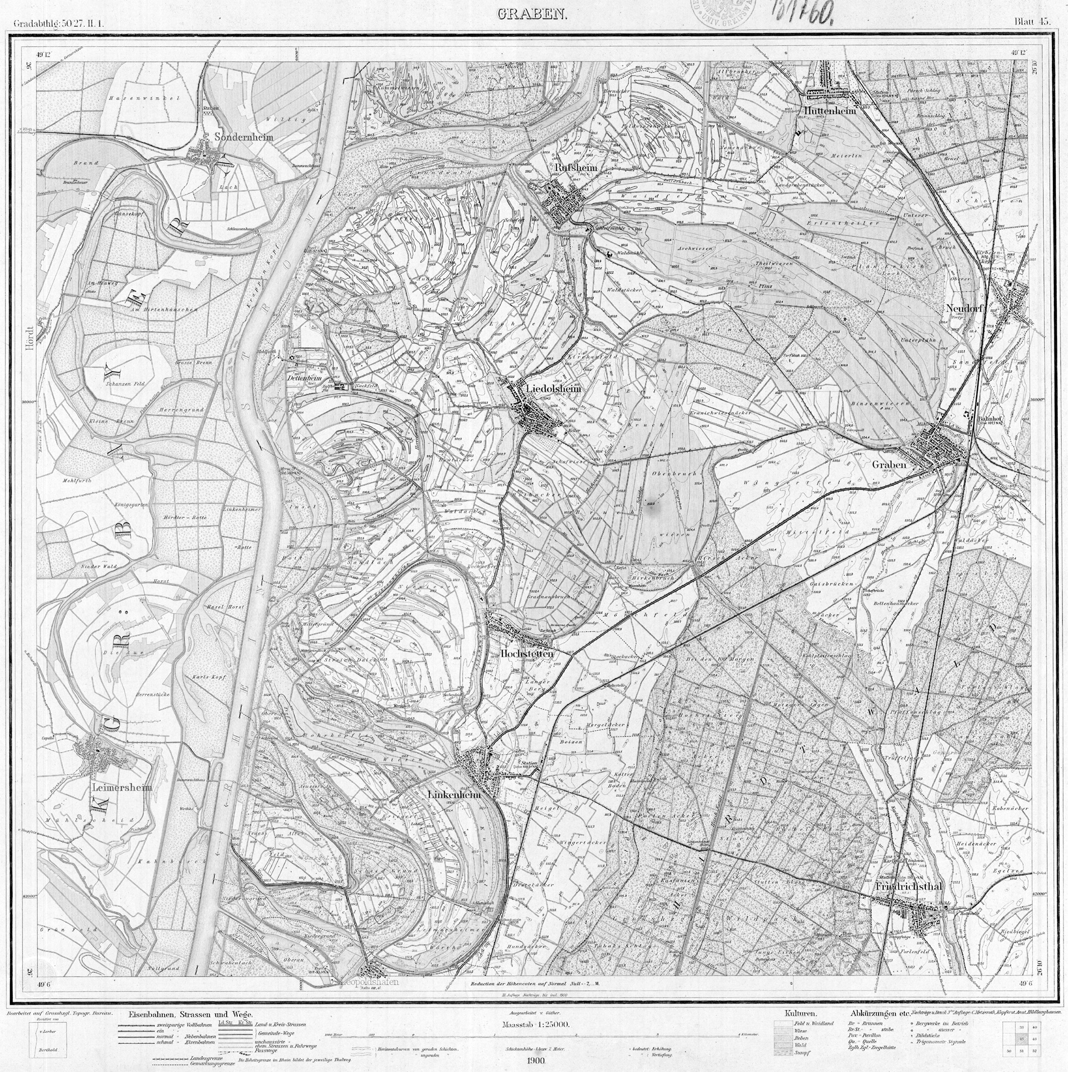
- ↑ Topografisches Bureau Baden (ed.): Meßtischblatt Nr. 45 Graben. Karlsruhe 1900 ( online ).
literature
- Topographic map 1: 25,000 Baden-Württemberg, as single sheet No. 6716 Germersheim, No. 6816 Graben-Neudorf, No. 6817 Bruchsal and No. 6916 Karlsruhe Nord
Web links
-
Map of the course and catchment area of the Extended Pfinz Canal on: State Institute for the Environment Baden-Württemberg (LUBW) ( information )
(from a little south of Friedrichtal to northwest of Huttenheim) -
Map of the upper course of the name of the Extended Pfinz Canal from a trench confluence east of Liedolsheim, on: Geoportal Baden-Württemberg ( information )
Please move the map section for the further course. - Measuring table sheets in the Deutsche Fotothek :
- 6716 Philippsburg from 1878
- 6816 trench from 1876
- 6817 Bruchsal from 1876
- 6916 Carlsruhe from 1876