
Long hole (oxbow lake)
|
Langes Loch Schlute Rhine kilometer 373 oxbow lake northwest of Leopoldshafen |
||
 Waters, sand and gravel banks, forests and Rhine dams in the area around the Lange Loch , around 1817 and 2015 |
||
| Data | ||
| Water code | DE : 237514 | |
| location |
Northern Lower Rhine Valley
|
|
| River system | Rhine | |
| Junction | from the Rhine at Rhine km 372.8 49 ° 7 ′ 20 ″ N , 8 ° 21 ′ 56 ″ E |
|
| Source height | approx. 99.6 m above sea level NHN | |
| muzzle | in the Rhine at Rhine km 373.6 Coordinates: 49 ° 7 '46 " N , 8 ° 22' 3" E 49 ° 7 '46 " N , 8 ° 22' 3" E |
|
| Mouth height | approx. 99.3 m above sea level NHN | |
| Height difference | approx. 0.3 m | |
| Bottom slope | approx. 0.27 ‰ | |
| length | approx. 1.1 km | |
 The long hole with the inlet structure built in 1996 |
||
The Lange Loch (also Schlute Rheinkilometer 373 or Altarm northwest of Leopoldshafen ) is a tributary to the right of the Rhine in the communities Eggenstein-Leopoldshafen and Linkenheim-Hochstetten ( Karlsruhe district , Baden-Württemberg ). It is located north of the NATO ramp at the Leimersheim ferry between the towpath and the Rheindamm XXX .
History and course
Before 1772, the Rhine flowed northwest of the town of Schröck (renamed Leopoldshafen in 1833 ) through the meander , which is now known as the Linkenheimer Altrhein or the Dead Rhine and is traversed by the Lower Rhine Canal . During a flood in 1772, the Rhine collapsed into the Heinlein Rhine , an oxbow river along the Leimersheim dam . The new course of the Rhine threatened the town on the left bank of the Rhine. Despite extensive efforts - 392,000 fascines were installed and ships sunk at the breakthrough point - it was not possible to steer the Rhine into its old bed, so that the Heinlein-Rhine became the new main course within a few years.
The long hole is located in the area where the Heinlein-Rhein and the old course of the Rhine confluence before 1772. According to maps made around 1800, this is where the Schröcker Köpfel was located - an island that was forested in the south and merged into a sand or gravel bank in the north . A branch of the old course of the Rhine separated the Schröcker Köpfel from the Schröcker Heck forest bordering to the south . The tributary flows into the Heinlein-Rhein at the southern end of the Long Hole . The valley path of the Rhine in 1817 was in the Heinlein Rhine . At the level of Langen hole he turned to the northwest and rounded the Karl head and the hazel forest . Another arm of the Rhine branched off at the Langen Loch , running to the right of the Karlskopf , taking up the old course of the Rhine before 1772 and flowing into the main course at the Haselforst . When the Rhine was corrected according to the plans of Johann Gottfried Tulla , the Rhine was laid in a straight river bed. The new course of the Rhine roughly corresponds to the Heinlein Rhine ; the Haselforst is crossed in the Linkenheimer Average , which began in 1826 .
Topographic maps from 1876, 1900 and 1936 show tributaries of the Rhine in the area of the Long Hole . A dam in the location of today's Rheindamm XXX is shown for the first time in 1882. In 1883 the Reitstegschleuse (also Reitstegschluse ) was built on the dam , a lock through which the Dead Rhine drained into the Lange Loch . From around 1925, the Metz double lock , a pumping station located around 1.5 kilometers to the north , took over the internal drainage . Since around 1950 internal drainage has been carried out via the Lower Rhine Canal, which flows into the Rhine near Philippsburg . During the rehabilitation of Rheindamm XXX , the Reitstegschleuse was removed in 2017; it is to be rebuilt by the association "Heimathaus Zehntscheuer" on the outskirts of Linkenheim.Hochstetten. The Leopoldshafen fishing club, founded in 1946, leased the Lange Loch before 1952 .
At present, the Lange Loch runs in the 100 to 150 meter wide foreland of the Rhine between the towpath and Rheindamm XXX . The 800 meter long tributary reaches a width of up to 40 meters. Approximately in the middle the long hole divides into two arms; the western arm falls dry when the water levels are low. The body of water lies entirely within the Rheinaue landscape protection area north of Karlsruhe . Before 1996, the long hole in the middle was connected to the Rhine via a small pipe passage in the towpath at Rhine kilometer 373.2; the outlet was via a larger culvert at the north end at Rhine kilometer 373.6. A forest path crossed the long hole above the inlet . The southern part of the Long Hole was flown through on around 45 days per year when the towpath was flooded. Digested sludge had been deposited in the southern part ; only duckweed grew here .
In the course of measures to improve the drainage conditions in the Rhine foreland, a new, larger inlet was built in 1996 at the southern end of the Langen Loch at Rhine kilometer 372.8. The bottom of the culvert is around two meters below mean water level , which ensures that the Langen Loch can flow through it all year round . The forest path that crossed it was removed without replacement.
As a result of the construction work, the digested sludge stored in the Langen Loch was largely flushed out, and gravelly areas were created in parts. New species of aquatic plants settled there, including the flooding water crowfoot in areas with strong flow . Investigations in 2003 revealed 21 species of fish, including nine species that are on the red list in Germany or Baden-Württemberg . A third of the species were typical river species; Young fish were disproportionately represented. The water quality corresponded to that of the Rhine.
In 2009 a downstream canal system was connected to the Lange Loch . For this purpose, an approximately 80-meter-long trench and a passage were built under a forest path. The approximately 1.5 kilometer long canal system was previously only connected downstream and was only flown through during floods. It ends on the Old Rhine around the island of Rott . The river flows through the new ditch from mean water. The aim of the measure was to create spawning grounds for fish species such as the wolffish and bullhead that lay their eggs in sand or gravel. The construction work was part of a conservation project, funded by the EU -Förderprogramms LIFE + co-financed.
Web links
- Map of the Langen Loch on: State Agency for the Environment Baden-Württemberg (LUBW) ( information )
Individual evidence
LUBW
Official online waterway map with a suitable section and the layers used here: Long hole
General introduction without default settings and layers: State Institute for the Environment Baden-Württemberg (LUBW) ( notes )
- ↑ a b Height according to the contour line image on the topographic map background layer or the digital terrain model of the online map.
- ↑ Length according to the waterway network layer ( AWGN ) .
- ↑ Field name in the property and water layer .
- ↑ Layer water name .
- ↑ Protected areas according to the relevant layers, nature partly according to the biotope layer .
Other evidence
- ↑ Josef Schmithüsen : Geographical land survey: The natural space units on sheet 161 Karlsruhe. Federal Institute for Regional Studies, Bad Godesberg 1952. → Online map (PDF; 5.1 MB)
-
↑ tungsten Grönitz: The Northern Upper Rhine valley between Rastatt and Mannheim. Old Rhine, alluvial forests and glacial gravel. In: Werner Konold (Ed.): Cultural landscapes in Baden-Württemberg. G.Braun, Karlsruhe 2014, ISBN 978-3-7650-8438-6 , pp. 168–173, here p. 170;
Konrad Dussel : 850 years of Leopoldshafen. Between the Rhine and the research center. Regionalkultur, Ubstadt-Weiher 2010, ISBN 978-3-89735-621-4 , p. 113;
Showcase of the Anglerverein Linkenheim 1963 eV at the passage to the Schlute system north of the Langen Loch (as of September 24, 2015). - ↑ Hans-Joachim Fischer: Documentation of renaturation measures and their ecological effects in the Rhine foreland. In: Naturschutz und Landschaftspflege Baden-Württemberg , ISSN 1437-0093 , 75 (2005), pp. 305–332, here p. 308.
- ↑ Heinz Musall: The development of the cultural landscape of the Rhine valley between Karlsruhe and Speyer from the late 16th to the late 19th century. (= Heidelberg geographical works , No. 22) Geographical Institute of the University of Heidelberg, Heidelberg 1969, pp. 151–153.
-
↑ Musall, development of culture landscape , cards 6, 38;
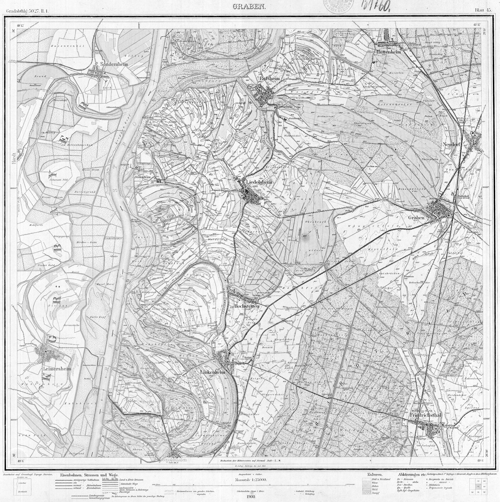
Map of the course of the Rhine from Basel to Grossh. Hessian border. In: Max Honsell : The correction of the Upper Rhine. From the Swiss border below Basel to Grossh. Hessian border below Mannheim; especially the Baden stake in the company. Braun, Karlsruhe 1885. ( Digital copy , PDF, 53.2 MB) - ↑ Topographical Atlas of the Grand Duchy of Baden. Sheet 45, trench. Scale 1: 25000, Giesecke & Devrient, Leipzig 1876 ( online ).
- ↑ Topographical Atlas of the Grand Duchy of Baden. Sheet 45, trench . Scale 1: 25000, 1900.
- ↑ Topographic map. Sheet 6816, dig. Edition of the Army Map Service of the Corps of Engineers of the US Army from 1951, based on German map from 1936 ( online ).
- ^ Map of the course of the Rhine from Basel to Grossh. Hessian border. In: Honsell, Correction of the Upper Rhine.
- ^ Reports of the Badische Neuesten Nachrichten on the website of the Friends of Home History, Heimathaus Zehntscheuer eV Linkenheim-Hochstetten (accessed on May 26, 2019).
- ^ Dussel, 850 years Leopoldshafen , p. 113.
- ^ Fischer, Documentation of Renaturation Measures , pp. 319 f, 327.
- ^ Fischer, Documentation of Renaturation Measures , pp. 317-319, 327.
- ↑ Fischer, Documentation of Renaturation Measures , p. 320 f.
- ↑ Klaus Kern: Selected LIFE measures between Rheinstetten and Philippsburg. In: State Institute for the Environment, Measurements and Nature Conservation Baden-Württemberg (Ed.): Lebendige Rheinauen. Nature, culture and LIFE in the northern Upper Rhine. (= Nature Conservation Spectrum, Topics. Volume 98) Regionalkultur, Ubstadt-Weiher 2010, ISBN 978-3-89735-615-3 , pp. 176–289, here pp. 241, 243.