
Mitteregg (Berwang municipality)
|
Mitteregg ( village ) locality cadastral community Mitteregg |
|||
|---|---|---|---|
|
|||
| Basic data | |||
| Pole. District , state | Reutte (RE), Tyrol | ||
| Judicial district | Reutte | ||
| Pole. local community | Berwang | ||
| Coordinates | 47 ° 22 '52 " N , 10 ° 43' 40" E | ||
| height | 1349 m above sea level A. | ||
| Residents of the village | 20 (January 1, 2020) | ||
| Building status | 12 (May 15, 2001 ) | ||
| Area d. KG | 11.7 km² | ||
| Post Code | 6622 Berwang | ||
| Statistical identification | |||
| Locality code | 16898 | ||
| Cadastral parish number | 86023 | ||
| Counting district / district | Berwang (70802 000) | ||
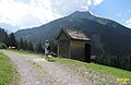
.jpg) Mitteregg with Marienkapelle |
|||
| Source: STAT : index of places ; BEV : GEONAM ; TIRIS | |||

Mitteregg is a village as well as a fraction ( locality ) and cadastral municipality with 20 inhabitants (as of January 1, 2020) in the municipality of Berwang in Tyrol .
The village is located in the Rotlechtal at 1349 m above sea level. A. , around 6 km south of the municipality capital Berwang.
The village consists of 12 houses, one of which is the school at the time, which has been closed since 1974.
It is the second highest village in the Tyrolean Zugspitz Arena. A narrow mountain road leads into the village, starting at the Anrauth junction.
The local mountain of the village is the 2217 meter high Schlierewand, it is located southwest of Mitteregg.
The Marienkapelle ( list entry ) at the entrance to the village, built in 1701, is the only listed building in Mitteregg.
Suwald Chapel with the Schlierewand in the background
.jpg)