Mitterhorn (Loferer Steinberge)
| Mitterhorn (Hinterhorn) | ||
|---|---|---|
|
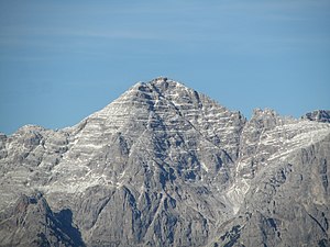
Mitterhorn from the south, taken from the Lärchfilzkogel |
||
| height | 2506 m above sea level A. | |
| location | Salzburg and Tyrol , Austria | |
| Mountains | Loferer Steinberge , Loferer and Leoganger Steinberge | |
| Dominance | 2.7 km → Großes Ochsenhorn | |
| Notch height | 336 m ↓ Small weir pit | |
| Coordinates | 47 ° 32 '57 " N , 12 ° 37' 43" E | |
|
|
||
| rock | Banked Dachstein limestone | |
| Age of the rock | Norium - Rhaetium | |
| First ascent | September 27, 1833 by Peter Karl Thurwieser (tourist) | |
The Mitterhorn (also called Hinterhorn or Großes Hinterhorn ) on the border between Tyrol and Salzburg is at an altitude of 2506 m above sea level. A. the second highest elevation of the Loferer Steinberge . It is the highest and most distinctive summit of the arm of the Loferer Steinberge, which branches off to the west from the Wehrgrubenjoch. From the south it appears as an almost even pyramid. The Nuaracher Höhenweg runs over the summit ; it is therefore one of the most frequently accessed peaks of the Loferer Steinberge.
Climbs
There are several climbs. The easiest one leads from the Loferer Hochtal via the Schmidt-Zabierow-Hütte on a well marked trail to the summit (approx. 4 hours). From the hut you can also reach the summit via the via ferrata "Nackter Hund" ( difficulty C / D ). Finally, the summit can be reached via the long Nuaracher Höhenweg from Sankt Ulrich am Pillersee . Another alternative is the ascent from Lastal (Ortisei - Weißleiten). The technically not very demanding, but nevertheless surefootedness and fitness demanding path leads in about 5 hours to the summit. The last section before the summit can optionally be shortened using the via ferrata.
The mountain, which is often climbed because of the easy ascent possibilities, offers a beautiful view of the Pillerseetal , the Kitzbühel Alps and the Hohe Tauern up to the Chiemsee in the direction of Bavaria when visibility is good .


