Modhera
| Modhera મોઢેરા |
||
|---|---|---|
|
|
||
| State : |
|
|
| State : | Gujarat | |
| District : | Mehsana | |
| Sub-district : | Becharaji | |
| Location : | 23 ° 35 ' N , 72 ° 8' E | |
| Height : | 75 m | |
| Area : | 24.36 km² | |
| Residents : | 6,373 (2011) | |
| Population density : | 262 inhabitants / km² | |
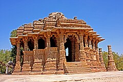
| Sun temple and temple pond in Modhera | ||
Modhera ( Gujarati મોઢેરા ) is a large village with around 6,400 inhabitants (2011 census) in the center of the Indian state of Gujarat . It is known for its Surya temple from the early 11th century.
location
Modhera is located on the Pushpavati River about 34 km (driving distance) south of the city of Patan or almost 100 km northwest of Ahmedabad at an altitude of about 58 m above sea level. d. The nearest train station is in the town of Mehsana, about 25 km to the east . The small pilgrimage town of Becharaji , but visited by many Hindus , is about 15 km to the southwest. The Narmada Canal , inaugurated in 2008, flows past not far from the town. The climate is mostly hot; Rain only falls in the summer monsoon season .
population
Official population statistics have only been kept and published since 1991. The increase in the small town population is mainly due to the immigration of families from the surrounding area.
| year | 1991 | 2001 | 2011 |
| Residents | k. A. | 5,908 | 6,373 |
The Gujarati and Hindi speaking population consists of approximately 95% Hindus and 5% Muslims ; other faith groups hardly play a role among the rural population of India. As is common in India, the male population is about 10% higher than the female.
economy
Agriculture has traditionally played an important role in the entire district of Mehsana; In the cities or larger towns, handicrafts, retail trade and services are also important. Temple tourism plays a subordinate role.
history
The village , which was quite remote in earlier times, belonged to the Solanki empire in the Middle Ages , which, however, was increasingly exposed to attacks by Islamic armies in the 11th century. In 1026 Mahmud of Ghazni plundered and destroyed the important Shiva temple of Somnath . Perhaps the almost simultaneous erection of the Sun Temple is directly related.
Attractions
The Sun Temple ( Surya -Mandir ), located about 500 m west of the village and built between 1026-1030 during the reign of Solanki King Bhimadeva I (r. 1022-1064), is one of the most important sacred buildings in Gujarat and all of India; However, it is no longer used for cultic purposes today, but is under the administration of the Archaeological Survey of India . The building essentially consists of four parts - a temple pond ( Surya Kund ) surrounded on all four sides by prism-like steps and small shrines , two richly carved side pillars of a former Torana gate, one raised by several steps and open on all sides carried by many pillars assembly hall ( Sabha Mandap ) and the actual temple ( Guda-Mandap ) comprising a laterally open entrance portico , a porch ( mandapa ) with 52 columns and a Kragkuppel with hanging keystone ( pendant vault consisting) and the approximately equal Sanktumsbereich from a tower and windowless cella ( garbhagriha ) and an inner intercourse ( pradakshinapatha ). The outer walls of Sabha Mandap and Guda Mandap are richly carved with figure and decorative reliefs .
Festivals
The annual dance festival, organized by the Tourism Corporation of Gujarat and held in the third week of January, brings together many people from almost all cultures in Modhera.
literature
- George Michell: The Hindu Temple. Architecture of a world religion. DuMont, Cologne 1991, pp. 154 ff, ISBN 3-7701-2770-6 .
- Marilia Albanese: Ancient India. From the origins to the 13th century. Karl-Müller-Verlag, Cologne, p. 178 ff., ISBN 3-89893-009-2 .
Web links
- Modhera, Temple of the Sun etc. - photos + information
- Modhera, Temple of the Sun etc. - photos + information
- Modhera, Temple of the Sun etc. - photos + information (English)
- Modhera, Temple of the Sun etc. - photos + information (English)
- Modhera, Temple of the Sun - Photos + Info (English)


