
Momarter oak


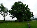
The Momart oak stood at about 335 meters above sea level within the natural subunit No. 144.64 Sellplatte in the Odenwald , about 200 meters east of the eponymous Momart , a district of the town of Bad König in the Odenwald district . The oak , classified as a natural monument , was in an open field directly on the edge of the sports field on Hohen Strasse.
On April 29, 2018 at around 8 p.m., the oak broke apart and fell onto the surrounding field and the adjacent Hohe Straße. Shortly after the case became known, a large number of Momarter residents came to say goodbye to their landmark.
Esotericists consider the location to be one of the power places of Leylines .
description
The Momarter oak was a sessile oak . The trunk appeared to be turned a little counterclockwise and tapered in the middle and was free of knots up to a height of about three meters. It had no cavity, but a lightning channel that led on the south side from the crown to the ground. The root area was partially exposed. The crown was dense, which made the tree appear overall in good condition and made a very vital impression. In the 1970s the oak was renovated and stabilized with a steel anchor. In January 2007, Hurricane Kyrill caused the main eastern branch and a smaller branch to be broken off, so that the crown no longer looked closed from this side.
In 1990 the trunk had a height of 1.3 meters with a total height of 20 meters and a crown diameter of 24 meters and a circumference of 4.5 meters. In 2007 the trunk had a circumference of 4.9 meters at the point of its smallest diameter and 5.0 meters at a height of 1.0 meters.
The age of the oak was given in the literature in 1990 with a proven 225 years. Other sources indicate the age with 300 to 350 years or even 600 years. The notice board placed next to the tree in 2008 names 400 years.
An oak tree as a court tree and part of the border demarcation at Momart was already mentioned in documents from 766, 795 and 819 about donations to the Fulda monastery , about the demarcation of the Muntat , and about the demarcation of the Michelstadt mark , which Einhard 815 for his services to Charlemagne received from his son Ludwig the Pious and bequeathed it to Lorsch Monastery in 819 , called.
photos

Sign board
South view

Storm damage

Lightning gutter
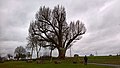
Winter view with a view of the destroyed main trunk stump

Remains of the destroyed oak in early November 2018


Others

There is another natural monument just a few dozen meters along the road leading out of the village. The three oaks are three strong and tall English oaks with a height of almost 20 meters and trunk circumferences of over two meters. The middle one has a natural monument and is named Otto Röhm Oak .
See also
literature
- Hans Joachim Fröhlich , Board of Trustees "Old Lovable Trees in Germany" eV, Wiesbaden: Paths to Old Trees Volume 1 - Hesse , WDV-Wirtschaftdienst Frankfurt am Main, 1990, ISBN 3-926181-06-0
- District committee of the Odenwaldkreis: Natural monuments in the Odenwald , Erbach 1995
- Gert Richter: Germany: Culture and Nature Guide South , Bertelsmann Lexikothek Verlag, 1996, p. 101
Web links
Individual evidence
- ^ Website of the city of Bad König accessed on November 6, 2016
- ^ Report in the Darmstädter Echo of April 30, 2018
- ↑ Naturopathic treatment in Bad König
- ↑ a b c notice board next to the oak (see picture)
- ^ A b Hans Joachim Fröhlich: Paths to old trees - Hessen, page 160. See also: Literature.
- ^ Georg Wilhelm Justin Wagner : The desertions in the Grand Duchy of Hesse , Darmstadt 1862, pp. 130-135 and pp. 244 ff.
Coordinates: 49 ° 43 ′ 34 " N , 9 ° 1 ′ 23" E