
Montchaude
| Montchaude | ||
|---|---|---|
|
||
| local community | Montmérac | |
| region | Nouvelle-Aquitaine | |
| Department | Charente | |
| Arrondissement | cognac | |
| Coordinates | 45 ° 27 ′ N , 0 ° 12 ′ W | |
| Post Code | 16300 | |
| Former INSEE code | 16224 | |
| Incorporation | January 1, 2016 | |
| status | Commune déléguée | |

Montchaude is a village and a former French community with 496 inhabitants (as of January 1 2017) in the department of Charente in the region Nouvelle-Aquitaine (before 2016 Poitou-Charentes ). It belonged to the arrondissement of Cognac and the canton of Charente-Sud .
With effect from January 1, 2016, the former municipalities of Montchaude and Lamérac were merged into a Commune nouvelle called Montmérac . The former municipalities have the status of a Commune déléguée in the new municipality . The administrative headquarters are in Montchaude.
Neighboring towns are Guimps in the northwest, Barret in the north, Barbezieux-Saint-Hilaire in the northeast, Reignac in the east, Le Tâtre in the southeast, Touvérac in the south and Lamérac in the west.
Population development
| year | 1962 | 1968 | 1975 | 1982 | 1990 | 1999 | 2008 | 2015 |
|---|---|---|---|---|---|---|---|---|
| Residents | 420 | 395 | 441 | 454 | 463 | 515 | 518 | 529 |
Attractions
- Castle of Montchaude
- Saint-Cybard Church
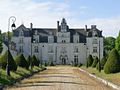
Castle of Montchaude
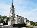
Saint-Cybard Church

