
Touvérac
| Touvérac | ||
|---|---|---|
|
||
| region | Nouvelle-Aquitaine | |
| Department | Charente | |
| Arrondissement | cognac | |
| Canton | Charente Sud | |
| Community association | 4B Sud Charente | |
| Coordinates | 45 ° 23 ′ N , 0 ° 13 ′ W | |
| height | 68-156 m | |
| surface | 18.19 km 2 | |
| Residents | 626 (January 1, 2017) | |
| Population density | 34 inhabitants / km 2 | |
| Post Code | 16360 | |
| INSEE code | 16384 | |
 Town hall (Mairie) of Touvérac |
||

TOUVERAC is a western French community with 626 inhabitants (as of January 1 2017) in the department of Charente in the region Nouvelle-Aquitaine (before 2016 Poitou-Charentes ). The municipality belongs to the Arrondissement of Cognac and the canton of Charente-Sud ( Baignes-Sainte-Radegonde until 2015 ). The inhabitants are called Touvéracois .
location
Touvérac is located about 35 kilometers southwest of Angoulême on the Charente , which borders the municipality in the east. Touvérac is surrounded by the neighboring communities of Montmérac in the north and northwest, Le Tâtre in the north, Condéon in the northeast, Oriolles in the east, Boisbreteau in the southeast, Bors (Canton de Charente-Sud) in the south and Baignes-Sainte-Radegonde in the south and west.
Population development
| year | 1962 | 1968 | 1975 | 1982 | 1990 | 1999 | 2006 | 2017 |
| Residents | 721 | 722 | 668 | 765 | 643 | 577 | 709 | 626 |
| Sources: Cassini and INSEE | ||||||||
Attractions
- Saint-Martin church from the 11th century
- 19th century Saint-Bernard castle
- Baignes Castle from the 13th century

Saint Martin Church
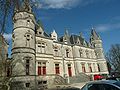
Saint-Bernard Castle


Personalities
- Adhémar Esmein (1848–1913), constitutional scholar and legal historian