
Graves-Saint-Amant
| Graves-Saint-Amant | ||
|---|---|---|
.svg)
|
|
|
| region | Nouvelle-Aquitaine | |
| Department | Charente | |
| Arrondissement | cognac | |
| Canton | Charente-Champagne | |
| Community association | Grand Cognac | |
| Coordinates | 45 ° 39 ′ N , 0 ° 6 ′ W | |
| height | 14-97 m | |
| surface | 8.99 km 2 | |
| Residents | 334 (January 1, 2017) | |
| Population density | 37 inhabitants / km 2 | |
| Post Code | 16120 | |
| INSEE code | 16297 | |
 Town hall (Mairie) of Graves-Saint-Amant |
||

Graves-Saint-Amant is a western French community with 334 inhabitants (as of January 1 2017) in the department of Charente in the region Nouvelle-Aquitaine (before 2016 Poitou-Charentes ). The municipality belongs to the arrondissement of Cognac and the canton of Charente-Champagne (until 2015 Châteauneuf-sur-Charente ). The inhabitants are called Gravois .
location
Graves-Saint-Amant is located about 20 kilometers west-southwest of Angoulême on the Charente , which borders the municipality in the north. Graves-Saint-Amant is surrounded by the neighboring communities of Bassac in the north, Saint-Simon in the north-east, Angeac-Charente in the south and east, Bouteville in the south and south-east and Saint-Même-les-Carrières in the west and north-west.
history
In 1997 the communes of Graves and Saint-Amant-de-Graves were merged to form today's commune.
Population development
| year | 1962 | 1968 | 1975 | 1982 | 1990 | 1999 | 2006 | 2013 |
| Residents | 214 | 227 | 217 | 203 | 259 | 338 | 313 | 339 |
| Sources: Cassini and INSEE | ||||||||
Attractions
- Saint-Martin in Graves church from the 12th century, renovations from the 15th century, historic monument since 1986
- Saint-Amant church, former priory, rebuilt in the 17th century
- Bois-Charente castle from the 16th century

Saint Martin Church

Saint-Amant church
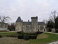
Bois-Charente Castle


