
Mérignac (Charente)
| Mérignac | ||
|---|---|---|
.svg)
|
|
|
| region | Nouvelle-Aquitaine | |
| Department | Charente | |
| Arrondissement | cognac | |
| Canton | Jarnac | |
| Community association | Grand Cognac | |
| Coordinates | 45 ° 42 ′ N , 0 ° 5 ′ W | |
| height | 23-101 m | |
| surface | 18.51 km 2 | |
| Residents | 839 (January 1, 2017) | |
| Population density | 45 inhabitants / km 2 | |
| Post Code | 16200 | |
| INSEE code | 16216 | |
 City Hall (Mairie) of Mérignac |
||

Mérignac is a southwestern French community with 839 inhabitants (as of January 1 2017) in the Charente in the region Nouvelle-Aquitaine (before 2016: Poitou-Charentes ). The municipality belongs to the arrondissement of Cognac and the canton of Jarnac . The inhabitants are called Mérignacais .
location
Mérignac is about 20 kilometers west-northwest of Angoulême . Mérignac is surrounded by the neighboring communities of Fleurac in the north, Échallat in the east and northeast, Douzat in the east, Moulidars in the southeast, Bassac in the south, Triac-Lautrait in the southwest and Foussignac in the west.
The National Route 141 runs through the municipality .
Population development
| year | 1962 | 1968 | 1975 | 1982 | 1990 | 1999 | 2006 | 2017 |
| Residents | 763 | 747 | 806 | 728 | 751 | 717 | 691 | 839 |
| Sources: Cassini and INSEE | ||||||||
Attractions
- Saint-Pierre church, monument historique since 1925
- Villars Castle, built in the 15th century, has been a monument historique since 2007
- Mérignac Castle, built in the 16th century,

Saint-Pierre church
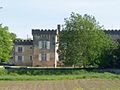
Villars Castle
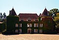
Mérignac Castle


Web links
Commons : Mérignac - collection of images, videos and audio files