
Saint-Amant-de-Nouère
| Saint-Amant-de-Nouère | ||
|---|---|---|
|
||
| region | Nouvelle-Aquitaine | |
| Department | Charente | |
| Arrondissement | cognac | |
| Canton | Val de Nouère | |
| Community association | Rouillacais | |
| Coordinates | 45 ° 45 ′ N , 0 ° 0 ′ E | |
| height | 62-132 m | |
| surface | 11.15 km 2 | |
| Residents | 404 (January 1, 2017) | |
| Population density | 36 inhabitants / km 2 | |
| Post Code | 16170 | |
| INSEE code | 16298 | |
 Town hall (Mairie) of Saint-Amant-de-Nouère |
||

Saint-Amant-de-Nouère is a western French community with 404 inhabitants (at January 1, 2017) in the department of Charente in the region Nouvelle-Aquitaine (before 2016 Poitou-Charentes ). The municipality belongs to the arrondissement of Cognac (until 2017 Angoulême ) and the canton of Val de Nouère (until 2015 Hiersac ).
location
Saint-Amant-de-Nouère is located about 15 kilometers northwest of Angoulême in the cultural landscape of the Angoumois . The river Nouère limits the municipality to the east. Saint-Amant-de-Nouère is surrounded by the neighboring communities of Saint-Cybardeaux in the north and north-west, Saint-Genis-d'Hiersac in the east, Asnières-sur-Nouère in the south-east, Douzat in the south and Échallat in the west.
Population development
| year | 1962 | 1968 | 1975 | 1982 | 1990 | 1999 | 2006 | 2017 |
| Residents | 359 | 352 | 331 | 350 | 372 | 382 | 380 | 404 |
| Sources: Cassini and INSEE | ||||||||
Attractions
- Saint-Amant church
- Fontguyon Castle and Domain, built in 1570, since 1989/1994 Monument historique
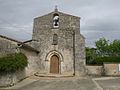
Saint-Amant church
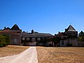
Fontguyon Castle

